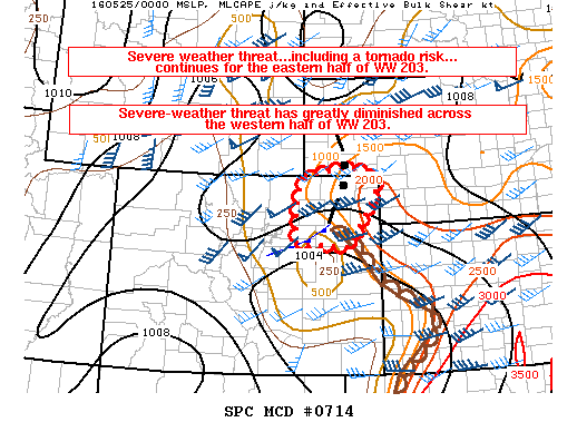
NOAA Storm Prediction Center Mesoscale Discussion 716
MD 0716 CONCERNING SEVERE THUNDERSTORM WATCH 205… FOR EAST-CENTRAL OK/FAR WEST-CENTRAL AR MESOSCALE DISCUSSION 0716 NWS STORM PREDICTION CENTER NORMAN OK 0839 PM CDT TUE MAY 24 2016 AREAS AFFECTED…EAST-CENTRAL OK/FAR WEST-CENTRAL AR CONCERNING…SEVERE THUNDERSTORM WATCH 205… VALID 250139Z – 250315Z THE SEVERE WEATHER THREAT FOR SEVERE THUNDERSTORM WATCH 205 CONTINUES. SUMMARY…SEVERE-WEATHER THREAT SHOULD GRADUALLY DIMINISH THROUGH THE EVENING WITH… Read more →