Primary Menu Search
  • About us
    • About us
    • How We Forecast
    • Archives
  • Our Services
    • Live Stream: Severe Weather Discussions
    • Go Storm Chasing
    • Pictures
  • Contact Us!
  • Jobs
  • Weather Safety
    • Weather Safety
    • Hurricane Preparedness Tips
    • Road Conditions
    • Current Conditions
    • South Mississippi river forecasts
    • Forecasting Presentation
  • Login

NickelBlock Forecasting

Funny name. Serious data.

Secondary Menu
  • Severe Weather Outlook
    • Severe Outlook through Day 8
    • Severe Outlook By State
    • Today’s Severe Weather Threat
    • Today’s Tornado Threat
    • Today’s Severe Wind Threat
    • Today’s Severe Hail Threat
    • Excessive Rainfall Forecasts
  • Short Term Forecast
    • Current Radar & Satellite
    • Detailed National Forecast Discussion
    • National Surface Maps
    • National Temperatures
    • National Precipitation Chances
    • National Precipitation Estimates
    • National Snowfall Estimates
    • National Ice Estimates
    • National Convective Outlook
    • Public RAPTOR Map
    • Model Data Viewer
  • Tropics
  • 10 Day Trend
  • Seasonal Discussion
You are here: Home ∼ Page 467
NOAA Storm Prediction Center Mesoscale Discussion 746

NOAA Storm Prediction Center Mesoscale Discussion 746

Alomar Sharpe Thursday, May 26, 2016 // 3:46 pm

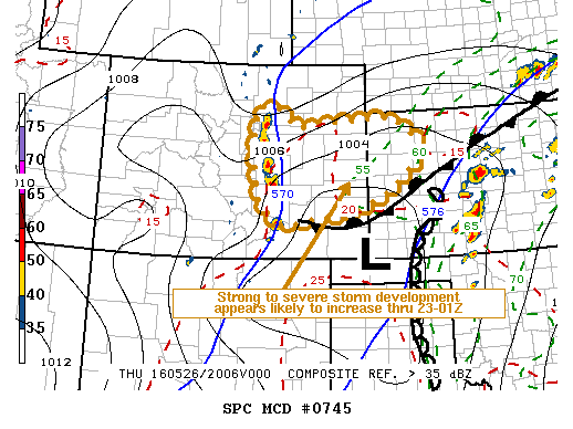
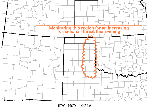
MD 0746 CONCERNING TORNADO WATCH 214… FOR EASTERN TEXAS PANHANDLE MESOSCALE DISCUSSION 0746 NWS STORM PREDICTION CENTER NORMAN OK 0345 PM CDT THU MAY 26 2016 AREAS AFFECTED…EASTERN TEXAS PANHANDLE CONCERNING…TORNADO WATCH 214… VALID 262045Z – 262145Z THE SEVERE WEATHER THREAT FOR TORNADO WATCH 214 CONTINUES. SUMMARY…THUNDERSTORM AND SEVERE POTENTIAL ARE GRADUALLY INCREASING…AND A SMALL WATCH MAY BE REQUIRED BY… Read more →

Posted in Archive, Severe Weather Discussions | Tagged Severe Weather, Watches and Warnings, weather
NOAA Storm Prediction Center Mesoscale Discussion 745

NOAA Storm Prediction Center Mesoscale Discussion 745

Alomar Sharpe Thursday, May 26, 2016 // 3:24 pm

MD 0745 CONCERNING TORNADO WATCH 213… FOR PARTS OF CNTRL AND ERN COLORADO MESOSCALE DISCUSSION 0745 NWS STORM PREDICTION CENTER NORMAN OK 0323 PM CDT THU MAY 26 2016 AREAS AFFECTED…PARTS OF CNTRL AND ERN COLORADO CONCERNING…TORNADO WATCH 213… VALID 262023Z – 262230Z THE SEVERE WEATHER THREAT FOR TORNADO WATCH 213 CONTINUES. SUMMARY…STRONG TO SEVERE STORM DEVELOPMENT IS EXPECTED TO… Read more →

Posted in Archive, Severe Weather Discussions | Tagged Severe Weather, Watches and Warnings, weather

NOAA Storm Prediction Center Severe Thunderstorm Watch 217

Alomar Sharpe Thursday, May 26, 2016 // 3:15 pm

WW 217 SEVERE TSTM TX 262015Z – 270400Z URGENT – IMMEDIATE BROADCAST REQUESTED SEVERE THUNDERSTORM WATCH NUMBER 217 NWS STORM PREDICTION CENTER NORMAN OK 315 PM CDT THU MAY 26 2016 THE NWS STORM PREDICTION CENTER HAS ISSUED A * SEVERE THUNDERSTORM WATCH FOR PORTIONS OF WEST-CENTRAL TEXAS * EFFECTIVE THIS THURSDAY AFTERNOON AND EVENING FROM 315 PM UNTIL 1100… Read more →

Posted in Archive, Severe Weather Discussions | Tagged Severe Weather, Watches and Warnings, weather
NOAA Storm Prediction Center Mesoscale Discussion 744

NOAA Storm Prediction Center Mesoscale Discussion 744

Alomar Sharpe Thursday, May 26, 2016 // 2:44 pm

MD 0744 CONCERNING SEVERE POTENTIAL…WATCH POSSIBLE FOR WESTERN AND SOUTHWESTERN TEXAS MESOSCALE DISCUSSION 0744 NWS STORM PREDICTION CENTER NORMAN OK 0243 PM CDT THU MAY 26 2016 AREAS AFFECTED…WESTERN AND SOUTHWESTERN TEXAS CONCERNING…SEVERE POTENTIAL…WATCH POSSIBLE VALID 261943Z – 262145Z PROBABILITY OF WATCH ISSUANCE…60 PERCENT SUMMARY…CONVECTIVE INITIATION MAY OCCUR WITHIN THE NEXT 1-2 HOURS IN THE DISCUSSION AREA. A WW IS… Read more →

Posted in Archive, Severe Weather Discussions | Tagged Severe Weather, Watches and Warnings, weather
← Previous 1 … 466 467 468 … 2,028 Next →

Today’s Severe Weather Threat

SVR WX THREAT

Today’s Tornado Threat

SVR WX THREAT

Search The Site

Contributing Scientists

  • Alomar Sharpe
  • Amber Kulick
  • Branden Walker
  • Chris Vagasky
  • Colt Murray
  • Emily Riter
  • Kendall Junker
  • Matt Breland
  • Nick Lilja
  • NickelBlock Staff
  • Noah Gower

Wx Topics

2019 Atlantic Hurricane Season 2020 Atlantic hurricane Season Alabama Weather Amarillo weather Atlantic Hurricane Season Coronavirus COVID-19 COVID19 Earthquakes Flooding Geology Gulf Coast Weather hail hurricanes Louisiana Weather Mississippi Weather rain Severe Weather snow Texas Weather Thunderstorms Tornadoes Tropical Depressions Tropical Storms Tropical Weather tropics USGS Watches and Warnings weather Wind

What We Cover

  • Archive (10,136)
  • Climate (64)
  • Education (230)
  • Environment (8)
  • Forecasting (467)
  • Geology (210)
  • High Plains Weather (119)
  • Midwest Weather (35)
  • Northeast Weather (13)
  • Northwest Weather (5)
  • Not Weather (93)
  • Research (31)
  • River Flooding (23)
  • Severe Weather Discussions (8,640)
  • South Plains Weather (69)
  • Southeast Weather (312)
  • Space (19)
  • Storm Chasing (86)
  • Tropics (450)
  • Weather & Sports (4)
  • Weather & TV (37)
  • Weather History (8)
  • West Coast Weather (4)

Research

  • Conclusion: How multiple variables control TX/OK panhandle Spring severe weather
  • Findings: How multiple variables control TX/OK panhandle Spring severe weather
  • Methods: How multiple variables control TX/OK panhandle Spring severe weather
  • Introduction: How multiple variables control TX/OK panhandle Spring severe weather
  • Works Cited: How multiple variables control TX/OK panhandle Spring severe weather

Popular This Month

  • Remember that “Arctic Blast” people were posting about? Buckle up (6,957)
  • Another “Arctic Blast!” headed to the southeast says social media-rologists (2,420)
  • Arctic blast plunges Mississippi into ice age-like conditions colder than one of the moons of Jupiter (2,410)
  • More cold and snow has South Mississippi feeling like South Manitoba (1,888)
  • More wintry weather possible in South Mississippi next week (1,854)
  • Enough with the “Meteorologists get paid to be wrong” (1,617)
  • Afternoon Update: Snow possible for South Mississippi (960)
  • CIPS Analogs showing thunderstorms, possible severe weather, late next week for south Mississippi (949)
  • Freezing weather won’t kill all mosquitos (664)
  • Jan 16, south Mississippi morning snowfall update (541)
  • Instantly freeze water to make stalagmites (333)
  • Will it snow? A brief look at the steps to get it (318)

Primary Menu

  • About us
    • About us
    • How We Forecast
    • Archives
  • Our Services
    • Live Stream: Severe Weather Discussions
    • Go Storm Chasing
    • Pictures
  • Contact Us!
  • Jobs
  • Weather Safety
    • Weather Safety
    • Hurricane Preparedness Tips
    • Road Conditions
    • Current Conditions
    • South Mississippi river forecasts
    • Forecasting Presentation
  • Login

Secondary Menu

  • Severe Weather Outlook
    • Severe Outlook through Day 8
    • Severe Outlook By State
    • Today’s Severe Weather Threat
    • Today’s Tornado Threat
    • Today’s Severe Wind Threat
    • Today’s Severe Hail Threat
    • Excessive Rainfall Forecasts
  • Short Term Forecast
    • Current Radar & Satellite
    • Detailed National Forecast Discussion
    • National Surface Maps
    • National Temperatures
    • National Precipitation Chances
    • National Precipitation Estimates
    • National Snowfall Estimates
    • National Ice Estimates
    • National Convective Outlook
    • Public RAPTOR Map
    • Model Data Viewer
  • Tropics
  • 10 Day Trend
  • Seasonal Discussion

Copyright © 2026 NickelBlock Forecasting.

Powered by WordPress and Path. Back to Top

Google+
  • About us
  • Our Services
  • Contact Us!
  • Jobs
  • Weather Safety
  • Login