Primary Menu Search
  • About us
    • About us
    • How We Forecast
    • Archives
  • Our Services
    • Live Stream: Severe Weather Discussions
    • Go Storm Chasing
    • Pictures
  • Contact Us!
  • Jobs
  • Weather Safety
    • Weather Safety
    • Hurricane Preparedness Tips
    • Road Conditions
    • Current Conditions
    • South Mississippi river forecasts
    • Forecasting Presentation
  • Login

NickelBlock Forecasting

Funny name. Serious data.

Secondary Menu
  • Severe Weather Outlook
    • Severe Outlook through Day 8
    • Severe Outlook By State
    • Today’s Severe Weather Threat
    • Today’s Tornado Threat
    • Today’s Severe Wind Threat
    • Today’s Severe Hail Threat
    • Excessive Rainfall Forecasts
  • Short Term Forecast
    • Current Radar & Satellite
    • Detailed National Forecast Discussion
    • National Surface Maps
    • National Temperatures
    • National Precipitation Chances
    • National Precipitation Estimates
    • National Snowfall Estimates
    • National Ice Estimates
    • National Convective Outlook
    • Public RAPTOR Map
    • Model Data Viewer
  • Tropics
  • 10 Day Trend
  • Seasonal Discussion
You are here: Home ∼ Page 468

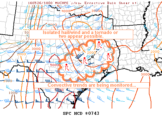
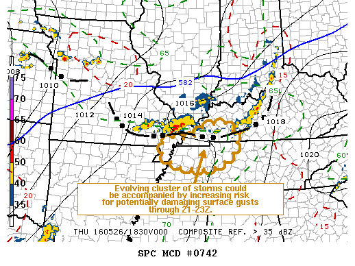
NOAA Storm Prediction Center Tornado Watch 216

Alomar Sharpe Thursday, May 26, 2016 // 2:10 pm

WW 216 TORNADO IA KS MO 261910Z – 270300Z URGENT – IMMEDIATE BROADCAST REQUESTED TORNADO WATCH NUMBER 216 NWS STORM PREDICTION CENTER NORMAN OK 210 PM CDT THU MAY 26 2016 THE NWS STORM PREDICTION CENTER HAS ISSUED A * TORNADO WATCH FOR PORTIONS OF SOUTHERN IOWA EXTREME EASTERN KANSAS NORTHWEST MISSOURI * EFFECTIVE THIS THURSDAY AFTERNOON AND EVENING FROM… Read more →

Posted in Archive, Severe Weather Discussions | Tagged Severe Weather, Watches and Warnings, weather

NOAA Storm Prediction Center Tornado Watch 215

Alomar Sharpe Thursday, May 26, 2016 // 1:55 pm

WW 215 TORNADO IA KS NE 261855Z – 270300Z URGENT – IMMEDIATE BROADCAST REQUESTED TORNADO WATCH NUMBER 215 NWS STORM PREDICTION CENTER NORMAN OK 155 PM CDT THU MAY 26 2016 THE NWS STORM PREDICTION CENTER HAS ISSUED A * TORNADO WATCH FOR PORTIONS OF SOUTHWEST IOWA NORTHERN AND NORTHWEST KANSAS SOUTHERN NEBRASKA * EFFECTIVE THIS THURSDAY AFTERNOON AND EVENING… Read more →

Posted in Archive, Severe Weather Discussions | Tagged Severe Weather, Watches and Warnings, weather
NOAA Storm Prediction Center Mesoscale Discussion 743

NOAA Storm Prediction Center Mesoscale Discussion 743

Alomar Sharpe Thursday, May 26, 2016 // 1:51 pm

MD 0743 CONCERNING SEVERE POTENTIAL…WATCH POSSIBLE FOR SOUTHEASTERN AND SOUTH CENTRAL TEXAS MESOSCALE DISCUSSION 0743 NWS STORM PREDICTION CENTER NORMAN OK 0150 PM CDT THU MAY 26 2016 AREAS AFFECTED…SOUTHEASTERN AND SOUTH CENTRAL TEXAS CONCERNING…SEVERE POTENTIAL…WATCH POSSIBLE VALID 261850Z – 262045Z PROBABILITY OF WATCH ISSUANCE…40 PERCENT SUMMARY…MESOSCALE CONVECTIVE SYSTEM CONTINUES SLOWLY EASTWARD NEAR CLL…WITH REDEVELOPMENT OCCURRING ON ITS WESTERN FLANK…. Read more →

Posted in Archive, Severe Weather Discussions | Tagged Severe Weather, Watches and Warnings, weather
NOAA Storm Prediction Center Mesoscale Discussion 742

NOAA Storm Prediction Center Mesoscale Discussion 742

Alomar Sharpe Thursday, May 26, 2016 // 1:46 pm

MD 0742 CONCERNING SEVERE POTENTIAL…WATCH POSSIBLE FOR PARTS OF SERN MO…WRN KY AND TN MESOSCALE DISCUSSION 0742 NWS STORM PREDICTION CENTER NORMAN OK 0145 PM CDT THU MAY 26 2016 AREAS AFFECTED…PARTS OF SERN MO…WRN KY AND TN CONCERNING…SEVERE POTENTIAL…WATCH POSSIBLE VALID 261845Z – 262045Z PROBABILITY OF WATCH ISSUANCE…40 PERCENT SUMMARY…IT IS NOT CERTAIN THAT A WATCH IS NEEDED…BUT TRENDS… Read more →

Posted in Archive, Severe Weather Discussions | Tagged Severe Weather, Watches and Warnings, weather

NOAA Storm Prediction Center Tornado Watch 214

Alomar Sharpe Thursday, May 26, 2016 // 1:30 pm

WW 214 TORNADO KS OK TX 261830Z – 270300Z URGENT – IMMEDIATE BROADCAST REQUESTED TORNADO WATCH NUMBER 214 NWS STORM PREDICTION CENTER NORMAN OK 130 PM CDT THU MAY 26 2016 THE NWS STORM PREDICTION CENTER HAS ISSUED A * TORNADO WATCH FOR PORTIONS OF CENTRAL AND EASTERN KANSAS WESTERN OKLAHOMA WESTERN NORTH TEXAS * EFFECTIVE THIS THURSDAY AFTERNOON AND… Read more →

Posted in Archive, Severe Weather Discussions | Tagged Severe Weather, Watches and Warnings, weather
← Previous 1 … 467 468 469 … 2,028 Next →

Today’s Severe Weather Threat

SVR WX THREAT

Today’s Tornado Threat

SVR WX THREAT

Search The Site

Contributing Scientists

  • Alomar Sharpe
  • Amber Kulick
  • Branden Walker
  • Chris Vagasky
  • Colt Murray
  • Emily Riter
  • Kendall Junker
  • Matt Breland
  • Nick Lilja
  • NickelBlock Staff
  • Noah Gower

Wx Topics

2019 Atlantic Hurricane Season 2020 Atlantic hurricane Season Alabama Weather Amarillo weather Atlantic Hurricane Season Coronavirus COVID-19 COVID19 Earthquakes Flooding Geology Gulf Coast Weather hail hurricanes Louisiana Weather Mississippi Weather rain Severe Weather snow Texas Weather Thunderstorms Tornadoes Tropical Depressions Tropical Storms Tropical Weather tropics USGS Watches and Warnings weather Wind

What We Cover

  • Archive (10,136)
  • Climate (64)
  • Education (230)
  • Environment (8)
  • Forecasting (467)
  • Geology (210)
  • High Plains Weather (119)
  • Midwest Weather (35)
  • Northeast Weather (13)
  • Northwest Weather (5)
  • Not Weather (93)
  • Research (31)
  • River Flooding (23)
  • Severe Weather Discussions (8,640)
  • South Plains Weather (69)
  • Southeast Weather (312)
  • Space (19)
  • Storm Chasing (86)
  • Tropics (450)
  • Weather & Sports (4)
  • Weather & TV (37)
  • Weather History (8)
  • West Coast Weather (4)

Research

  • Conclusion: How multiple variables control TX/OK panhandle Spring severe weather
  • Findings: How multiple variables control TX/OK panhandle Spring severe weather
  • Methods: How multiple variables control TX/OK panhandle Spring severe weather
  • Introduction: How multiple variables control TX/OK panhandle Spring severe weather
  • Works Cited: How multiple variables control TX/OK panhandle Spring severe weather

Popular This Month

  • Remember that “Arctic Blast” people were posting about? Buckle up (6,957)
  • Another “Arctic Blast!” headed to the southeast says social media-rologists (2,420)
  • Arctic blast plunges Mississippi into ice age-like conditions colder than one of the moons of Jupiter (2,410)
  • More cold and snow has South Mississippi feeling like South Manitoba (1,888)
  • More wintry weather possible in South Mississippi next week (1,854)
  • Enough with the “Meteorologists get paid to be wrong” (1,617)
  • Afternoon Update: Snow possible for South Mississippi (960)
  • CIPS Analogs showing thunderstorms, possible severe weather, late next week for south Mississippi (949)
  • Freezing weather won’t kill all mosquitos (664)
  • Jan 16, south Mississippi morning snowfall update (541)
  • Instantly freeze water to make stalagmites (333)
  • Will it snow? A brief look at the steps to get it (318)

Primary Menu

  • About us
    • About us
    • How We Forecast
    • Archives
  • Our Services
    • Live Stream: Severe Weather Discussions
    • Go Storm Chasing
    • Pictures
  • Contact Us!
  • Jobs
  • Weather Safety
    • Weather Safety
    • Hurricane Preparedness Tips
    • Road Conditions
    • Current Conditions
    • South Mississippi river forecasts
    • Forecasting Presentation
  • Login

Secondary Menu

  • Severe Weather Outlook
    • Severe Outlook through Day 8
    • Severe Outlook By State
    • Today’s Severe Weather Threat
    • Today’s Tornado Threat
    • Today’s Severe Wind Threat
    • Today’s Severe Hail Threat
    • Excessive Rainfall Forecasts
  • Short Term Forecast
    • Current Radar & Satellite
    • Detailed National Forecast Discussion
    • National Surface Maps
    • National Temperatures
    • National Precipitation Chances
    • National Precipitation Estimates
    • National Snowfall Estimates
    • National Ice Estimates
    • National Convective Outlook
    • Public RAPTOR Map
    • Model Data Viewer
  • Tropics
  • 10 Day Trend
  • Seasonal Discussion

Copyright © 2026 NickelBlock Forecasting.

Powered by WordPress and Path. Back to Top

Google+
  • About us
  • Our Services
  • Contact Us!
  • Jobs
  • Weather Safety
  • Login