Primary Menu Search
  • About us
    • About us
    • How We Forecast
    • Archives
  • Our Services
    • Live Stream: Severe Weather Discussions
    • Go Storm Chasing
    • Pictures
  • Contact Us!
  • Jobs
  • Weather Safety
    • Weather Safety
    • Hurricane Preparedness Tips
    • Road Conditions
    • Current Conditions
    • South Mississippi river forecasts
    • Forecasting Presentation
  • Login

NickelBlock Forecasting

Funny name. Serious data.

Secondary Menu
  • Severe Weather Outlook
    • Severe Outlook through Day 8
    • Severe Outlook By State
    • Today’s Severe Weather Threat
    • Today’s Tornado Threat
    • Today’s Severe Wind Threat
    • Today’s Severe Hail Threat
    • Excessive Rainfall Forecasts
  • Short Term Forecast
    • Current Radar & Satellite
    • Detailed National Forecast Discussion
    • National Surface Maps
    • National Temperatures
    • National Precipitation Chances
    • National Precipitation Estimates
    • National Snowfall Estimates
    • National Ice Estimates
    • National Convective Outlook
    • Public RAPTOR Map
    • Model Data Viewer
  • Tropics
  • 10 Day Trend
  • Seasonal Discussion
You are here: Home ∼ Page 400

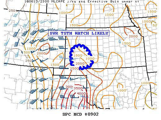
NOAA Storm Prediction Center Tornado Watch 252

Alomar Sharpe Monday, June 13, 2016 // 6:30 pm

WW 252 TORNADO OK TX 132330Z – 140700Z URGENT – IMMEDIATE BROADCAST REQUESTED TORNADO WATCH NUMBER 252 NWS STORM PREDICTION CENTER NORMAN OK 630 PM CDT MON JUN 13 2016 THE NWS STORM PREDICTION CENTER HAS ISSUED A * TORNADO WATCH FOR PORTIONS OF THE OKLAHOMA PANHANDLE THE TEXAS PANHANDLE AND NORTHERN PARTS OF THE TEXAS SOUTH PLAINS * EFFECTIVE… Read more →

Posted in Archive, Severe Weather Discussions | Tagged Severe Weather, Watches and Warnings, weather
NOAA Storm Prediction Center Mesoscale Discussion 902

NOAA Storm Prediction Center Mesoscale Discussion 902

Alomar Sharpe Monday, June 13, 2016 // 6:18 pm

MD 0902 CONCERNING SEVERE POTENTIAL…SEVERE THUNDERSTORM WATCH LIKELY FOR PORTIONS OF SWRN KS MESOSCALE DISCUSSION 0902 NWS STORM PREDICTION CENTER NORMAN OK 0617 PM CDT MON JUN 13 2016 AREAS AFFECTED…PORTIONS OF SWRN KS CONCERNING…SEVERE POTENTIAL…SEVERE THUNDERSTORM WATCH LIKELY VALID 132317Z – 140045Z PROBABILITY OF WATCH ISSUANCE…95 PERCENT SUMMARY…THE SVR RISK IS INCREASING E OF WW 250…LIKELY NECESSITATING THE ISSUANCE… Read more →

Posted in Archive, Severe Weather Discussions | Tagged Severe Weather, Watches and Warnings, weather
NOAA Storm Prediction Center Mesoscale Discussion 901

NOAA Storm Prediction Center Mesoscale Discussion 901

Alomar Sharpe Monday, June 13, 2016 // 6:13 pm

MD 0901 CONCERNING SEVERE POTENTIAL…TORNADO WATCH LIKELY FOR PORTIONS OF THE TX PANHANDLE/S PLAINS MESOSCALE DISCUSSION 0901 NWS STORM PREDICTION CENTER NORMAN OK 0612 PM CDT MON JUN 13 2016 AREAS AFFECTED…PORTIONS OF THE TX PANHANDLE/S PLAINS CONCERNING…SEVERE POTENTIAL…TORNADO WATCH LIKELY VALID 132312Z – 140015Z PROBABILITY OF WATCH ISSUANCE…95 PERCENT SUMMARY…CONVECTION SPREADING EWD/SEWD THROUGH THE EVENING HOURS WILL POSE A… Read more →

Posted in Archive, Severe Weather Discussions | Tagged Severe Weather, Watches and Warnings, weather
NOAA Storm Prediction Center Mesoscale Discussion 900

NOAA Storm Prediction Center Mesoscale Discussion 900

Alomar Sharpe Monday, June 13, 2016 // 5:58 pm

MD 0900 CONCERNING TORNADO WATCH 250… FOR A SMALL PART OF THE TX PANHANDLE MESOSCALE DISCUSSION 0900 NWS STORM PREDICTION CENTER NORMAN OK 0557 PM CDT MON JUN 13 2016 AREAS AFFECTED…A SMALL PART OF THE TX PANHANDLE CONCERNING…TORNADO WATCH 250… VALID 132257Z – 140000Z THE SEVERE WEATHER THREAT FOR TORNADO WATCH 250 CONTINUES. SUMMARY…SIGNIFICANT SVR RISK IS INCREASING IN… Read more →

Posted in Archive, Severe Weather Discussions | Tagged Severe Weather, Watches and Warnings, weather
NOAA Storm Prediction Center Mesoscale Discussion 899

NOAA Storm Prediction Center Mesoscale Discussion 899

Alomar Sharpe Monday, June 13, 2016 // 5:17 pm

MD 0899 CONCERNING TORNADO WATCH 250… FOR PORTIONS OF ERN CO…WRN KS…FAR SWRN NEB…TX/OK PANHANDLES…NERN NM MESOSCALE DISCUSSION 0899 NWS STORM PREDICTION CENTER NORMAN OK 0516 PM CDT MON JUN 13 2016 AREAS AFFECTED…PORTIONS OF ERN CO…WRN KS…FAR SWRN NEB…TX/OK PANHANDLES…NERN NM CONCERNING…TORNADO WATCH 250… VALID 132216Z – 132345Z THE SEVERE WEATHER THREAT FOR TORNADO WATCH 250 CONTINUES. SUMMARY…THE SVR… Read more →

Posted in Archive, Severe Weather Discussions | Tagged Severe Weather, Watches and Warnings, weather
← Previous 1 … 399 400 401 … 2,028 Next →

Today’s Severe Weather Threat

SVR WX THREAT

Today’s Tornado Threat

SVR WX THREAT

Search The Site

Contributing Scientists

  • Alomar Sharpe
  • Amber Kulick
  • Branden Walker
  • Chris Vagasky
  • Colt Murray
  • Emily Riter
  • Kendall Junker
  • Matt Breland
  • Nick Lilja
  • NickelBlock Staff
  • Noah Gower

Wx Topics

2019 Atlantic Hurricane Season 2020 Atlantic hurricane Season Alabama Weather Amarillo weather Atlantic Hurricane Season Coronavirus COVID-19 COVID19 Earthquakes Flooding Geology Gulf Coast Weather hail hurricanes Louisiana Weather Mississippi Weather rain Severe Weather snow Texas Weather Thunderstorms Tornadoes Tropical Depressions Tropical Storms Tropical Weather tropics USGS Watches and Warnings weather Wind

What We Cover

  • Archive (10,136)
  • Climate (64)
  • Education (230)
  • Environment (8)
  • Forecasting (467)
  • Geology (210)
  • High Plains Weather (119)
  • Midwest Weather (35)
  • Northeast Weather (13)
  • Northwest Weather (5)
  • Not Weather (93)
  • Research (31)
  • River Flooding (23)
  • Severe Weather Discussions (8,640)
  • South Plains Weather (69)
  • Southeast Weather (312)
  • Space (19)
  • Storm Chasing (86)
  • Tropics (450)
  • Weather & Sports (4)
  • Weather & TV (37)
  • Weather History (8)
  • West Coast Weather (4)

Research

  • Conclusion: How multiple variables control TX/OK panhandle Spring severe weather
  • Findings: How multiple variables control TX/OK panhandle Spring severe weather
  • Methods: How multiple variables control TX/OK panhandle Spring severe weather
  • Introduction: How multiple variables control TX/OK panhandle Spring severe weather
  • Works Cited: How multiple variables control TX/OK panhandle Spring severe weather

Popular This Month

  • Remember that “Arctic Blast” people were posting about? Buckle up (6,957)
  • Another “Arctic Blast!” headed to the southeast says social media-rologists (2,420)
  • Arctic blast plunges Mississippi into ice age-like conditions colder than one of the moons of Jupiter (2,410)
  • More cold and snow has South Mississippi feeling like South Manitoba (1,888)
  • More wintry weather possible in South Mississippi next week (1,854)
  • Enough with the “Meteorologists get paid to be wrong” (1,617)
  • Afternoon Update: Snow possible for South Mississippi (960)
  • CIPS Analogs showing thunderstorms, possible severe weather, late next week for south Mississippi (949)
  • Freezing weather won’t kill all mosquitos (664)
  • Jan 16, south Mississippi morning snowfall update (541)
  • Instantly freeze water to make stalagmites (333)
  • Will it snow? A brief look at the steps to get it (318)

Primary Menu

  • About us
    • About us
    • How We Forecast
    • Archives
  • Our Services
    • Live Stream: Severe Weather Discussions
    • Go Storm Chasing
    • Pictures
  • Contact Us!
  • Jobs
  • Weather Safety
    • Weather Safety
    • Hurricane Preparedness Tips
    • Road Conditions
    • Current Conditions
    • South Mississippi river forecasts
    • Forecasting Presentation
  • Login

Secondary Menu

  • Severe Weather Outlook
    • Severe Outlook through Day 8
    • Severe Outlook By State
    • Today’s Severe Weather Threat
    • Today’s Tornado Threat
    • Today’s Severe Wind Threat
    • Today’s Severe Hail Threat
    • Excessive Rainfall Forecasts
  • Short Term Forecast
    • Current Radar & Satellite
    • Detailed National Forecast Discussion
    • National Surface Maps
    • National Temperatures
    • National Precipitation Chances
    • National Precipitation Estimates
    • National Snowfall Estimates
    • National Ice Estimates
    • National Convective Outlook
    • Public RAPTOR Map
    • Model Data Viewer
  • Tropics
  • 10 Day Trend
  • Seasonal Discussion

Copyright © 2026 NickelBlock Forecasting.

Powered by WordPress and Path. Back to Top

Google+
  • About us
  • Our Services
  • Contact Us!
  • Jobs
  • Weather Safety
  • Login