Primary Menu Search
  • About us
    • About us
    • How We Forecast
    • Archives
  • Our Services
    • Live Stream: Severe Weather Discussions
    • Go Storm Chasing
    • Pictures
  • Contact Us!
  • Jobs
  • Weather Safety
    • Weather Safety
    • Hurricane Preparedness Tips
    • Road Conditions
    • Current Conditions
    • South Mississippi river forecasts
    • Forecasting Presentation
  • Login

NickelBlock Forecasting

Funny name. Serious data.

Secondary Menu
  • Severe Weather Outlook
    • Severe Outlook through Day 8
    • Severe Outlook By State
    • Today’s Severe Weather Threat
    • Today’s Tornado Threat
    • Today’s Severe Wind Threat
    • Today’s Severe Hail Threat
    • Excessive Rainfall Forecasts
  • Short Term Forecast
    • Current Radar & Satellite
    • Detailed National Forecast Discussion
    • National Surface Maps
    • National Temperatures
    • National Precipitation Chances
    • National Precipitation Estimates
    • National Snowfall Estimates
    • National Ice Estimates
    • National Convective Outlook
    • Public RAPTOR Map
    • Model Data Viewer
  • Tropics
  • 10 Day Trend
  • Seasonal Discussion
You are here: Home ∼ Page 401

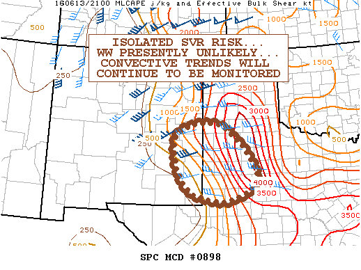
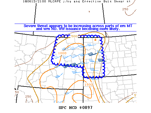
NOAA Storm Prediction Center Severe Thunderstorm Watch 251

Alomar Sharpe Monday, June 13, 2016 // 5:00 pm

WW 251 SEVERE TSTM MT ND 132145Z – 140500Z URGENT – IMMEDIATE BROADCAST REQUESTED SEVERE THUNDERSTORM WATCH NUMBER 251 NWS STORM PREDICTION CENTER NORMAN OK 445 PM CDT MON JUN 13 2016 THE NWS STORM PREDICTION CENTER HAS ISSUED A * SEVERE THUNDERSTORM WATCH FOR PORTIONS OF EASTERN MONTANA WESTERN NORTH DAKOTA * EFFECTIVE THIS MONDAY AFTERNOON FROM 445 PM… Read more →

Posted in Archive, Severe Weather Discussions | Tagged Severe Weather, Watches and Warnings, weather
NOAA Storm Prediction Center Mesoscale Discussion 898

NOAA Storm Prediction Center Mesoscale Discussion 898

Alomar Sharpe Monday, June 13, 2016 // 4:44 pm

MD 0898 CONCERNING SEVERE POTENTIAL…WATCH UNLIKELY FOR PORTIONS OF THE TX S PLAINS/PERMIAN BASIN…SERN NM MESOSCALE DISCUSSION 0898 NWS STORM PREDICTION CENTER NORMAN OK 0443 PM CDT MON JUN 13 2016 AREAS AFFECTED…PORTIONS OF THE TX S PLAINS/PERMIAN BASIN…SERN NM CONCERNING…SEVERE POTENTIAL…WATCH UNLIKELY VALID 132143Z – 140015Z PROBABILITY OF WATCH ISSUANCE…20 PERCENT SUMMARY…AN ISOLATED SVR RISK MAY ACCOMPANY CONVECTION SPREADING… Read more →

Posted in Archive, Severe Weather Discussions | Tagged Severe Weather, Watches and Warnings, weather
NOAA Storm Prediction Center Mesoscale Discussion 897

NOAA Storm Prediction Center Mesoscale Discussion 897

Alomar Sharpe Monday, June 13, 2016 // 4:41 pm

MD 0897 CONCERNING SEVERE POTENTIAL…WATCH LIKELY FOR PORTIONS OF ERN MT AND WRN ND MESOSCALE DISCUSSION 0897 NWS STORM PREDICTION CENTER NORMAN OK 0440 PM CDT MON JUN 13 2016 AREAS AFFECTED…PORTIONS OF ERN MT AND WRN ND CONCERNING…SEVERE POTENTIAL…WATCH LIKELY VALID 132140Z – 132315Z PROBABILITY OF WATCH ISSUANCE…80 PERCENT SUMMARY…THE SEVERE THREAT ACROSS PARTS OF ERN MT INTO WRN… Read more →

Posted in Archive, Severe Weather Discussions | Tagged Severe Weather, Watches and Warnings, weather
Storm Prediction Center Jun 13, 2016 Afternoon Outlook

Storm Prediction Center Jun 13, 2016 Afternoon Outlook

Alomar Sharpe Monday, June 13, 2016 // 4:38 pm

SPC 2000Z Day 1 Outlook DAY 1 CONVECTIVE OUTLOOK NWS STORM PREDICTION CENTER NORMAN OK 0300 PM CDT MON JUN 13 2016 VALID 132000Z – 141200Z …THERE IS AN ENH RISK OF SEVERE THUNDERSTORMS OVER A PORTION OF THE CNTRL HIGH PLAINS… …THERE IS A SLGT RISK OF SEVERE THUNDERSTORMS OVER MUCH OF THE HIGH PLAINS… …THERE IS A MRGL… Read more →

Posted in Archive, Severe Weather Discussions | Tagged Severe Weather, weather
NOAA Storm Prediction Center Mesoscale Discussion 896

NOAA Storm Prediction Center Mesoscale Discussion 896

Alomar Sharpe Monday, June 13, 2016 // 3:52 pm

MD 0896 CONCERNING SEVERE THUNDERSTORM WATCH 249… FOR SERN MT…ERN WY…WRN SD…WRN NEB MESOSCALE DISCUSSION 0896 NWS STORM PREDICTION CENTER NORMAN OK 0351 PM CDT MON JUN 13 2016 AREAS AFFECTED…SERN MT…ERN WY…WRN SD…WRN NEB CONCERNING…SEVERE THUNDERSTORM WATCH 249… VALID 132051Z – 132145Z THE SEVERE WEATHER THREAT FOR SEVERE THUNDERSTORM WATCH 249 CONTINUES. SUMMARY…THREAT FOR SVR WIND GUSTS AND ISOLATED… Read more →

Posted in Archive, Severe Weather Discussions | Tagged Severe Weather, Watches and Warnings, weather
← Previous 1 … 400 401 402 … 2,028 Next →

Today’s Severe Weather Threat

SVR WX THREAT

Today’s Tornado Threat

SVR WX THREAT

Search The Site

Contributing Scientists

  • Alomar Sharpe
  • Amber Kulick
  • Branden Walker
  • Chris Vagasky
  • Colt Murray
  • Emily Riter
  • Kendall Junker
  • Matt Breland
  • Nick Lilja
  • NickelBlock Staff
  • Noah Gower

Wx Topics

2019 Atlantic Hurricane Season 2020 Atlantic hurricane Season Alabama Weather Amarillo weather Atlantic Hurricane Season Coronavirus COVID-19 COVID19 Earthquakes Flooding Geology Gulf Coast Weather hail hurricanes Louisiana Weather Mississippi Weather rain Severe Weather snow Texas Weather Thunderstorms Tornadoes Tropical Depressions Tropical Storms Tropical Weather tropics USGS Watches and Warnings weather Wind

What We Cover

  • Archive (10,136)
  • Climate (64)
  • Education (230)
  • Environment (8)
  • Forecasting (467)
  • Geology (210)
  • High Plains Weather (119)
  • Midwest Weather (35)
  • Northeast Weather (13)
  • Northwest Weather (5)
  • Not Weather (93)
  • Research (31)
  • River Flooding (23)
  • Severe Weather Discussions (8,640)
  • South Plains Weather (69)
  • Southeast Weather (312)
  • Space (19)
  • Storm Chasing (86)
  • Tropics (450)
  • Weather & Sports (4)
  • Weather & TV (37)
  • Weather History (8)
  • West Coast Weather (4)

Research

  • Conclusion: How multiple variables control TX/OK panhandle Spring severe weather
  • Findings: How multiple variables control TX/OK panhandle Spring severe weather
  • Methods: How multiple variables control TX/OK panhandle Spring severe weather
  • Introduction: How multiple variables control TX/OK panhandle Spring severe weather
  • Works Cited: How multiple variables control TX/OK panhandle Spring severe weather

Popular This Month

  • Remember that “Arctic Blast” people were posting about? Buckle up (6,957)
  • Another “Arctic Blast!” headed to the southeast says social media-rologists (2,420)
  • Arctic blast plunges Mississippi into ice age-like conditions colder than one of the moons of Jupiter (2,410)
  • More cold and snow has South Mississippi feeling like South Manitoba (1,888)
  • More wintry weather possible in South Mississippi next week (1,854)
  • Enough with the “Meteorologists get paid to be wrong” (1,617)
  • Afternoon Update: Snow possible for South Mississippi (960)
  • CIPS Analogs showing thunderstorms, possible severe weather, late next week for south Mississippi (949)
  • Freezing weather won’t kill all mosquitos (664)
  • Jan 16, south Mississippi morning snowfall update (541)
  • Instantly freeze water to make stalagmites (333)
  • Will it snow? A brief look at the steps to get it (318)

Primary Menu

  • About us
    • About us
    • How We Forecast
    • Archives
  • Our Services
    • Live Stream: Severe Weather Discussions
    • Go Storm Chasing
    • Pictures
  • Contact Us!
  • Jobs
  • Weather Safety
    • Weather Safety
    • Hurricane Preparedness Tips
    • Road Conditions
    • Current Conditions
    • South Mississippi river forecasts
    • Forecasting Presentation
  • Login

Secondary Menu

  • Severe Weather Outlook
    • Severe Outlook through Day 8
    • Severe Outlook By State
    • Today’s Severe Weather Threat
    • Today’s Tornado Threat
    • Today’s Severe Wind Threat
    • Today’s Severe Hail Threat
    • Excessive Rainfall Forecasts
  • Short Term Forecast
    • Current Radar & Satellite
    • Detailed National Forecast Discussion
    • National Surface Maps
    • National Temperatures
    • National Precipitation Chances
    • National Precipitation Estimates
    • National Snowfall Estimates
    • National Ice Estimates
    • National Convective Outlook
    • Public RAPTOR Map
    • Model Data Viewer
  • Tropics
  • 10 Day Trend
  • Seasonal Discussion

Copyright © 2026 NickelBlock Forecasting.

Powered by WordPress and Path. Back to Top

Google+
  • About us
  • Our Services
  • Contact Us!
  • Jobs
  • Weather Safety
  • Login