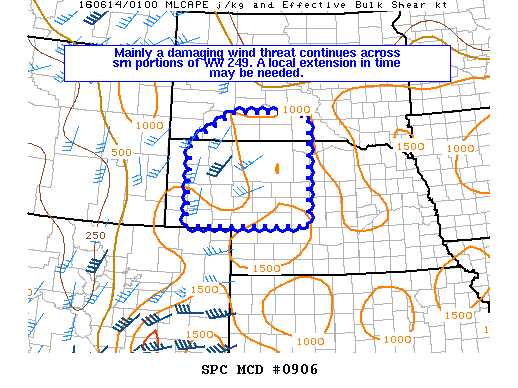
NOAA Storm Prediction Center Mesoscale Discussion 906
MD 0906 CONCERNING SEVERE THUNDERSTORM WATCH 249… FOR PORTIONS OF S-CNTRL SD AND WRN NEB MESOSCALE DISCUSSION 0906 NWS STORM PREDICTION CENTER NORMAN OK 0830 PM CDT MON JUN 13 2016 AREAS AFFECTED…PORTIONS OF S-CNTRL SD AND WRN NEB CONCERNING…SEVERE THUNDERSTORM WATCH 249… VALID 140130Z – 140230Z THE SEVERE WEATHER THREAT FOR SEVERE THUNDERSTORM WATCH 249 CONTINUES. SUMMARY…MAINLY A DAMAGING… Read more →