Primary Menu Search
  • About us
    • About us
    • How We Forecast
    • Archives
  • Our Services
    • Live Stream: Severe Weather Discussions
    • Go Storm Chasing
    • Pictures
  • Contact Us!
  • Jobs
  • Weather Safety
    • Weather Safety
    • Hurricane Preparedness Tips
    • Road Conditions
    • Current Conditions
    • South Mississippi river forecasts
    • Forecasting Presentation
  • Login

NickelBlock Forecasting

Funny name. Serious data.

Secondary Menu
  • Severe Weather Outlook
    • Severe Outlook through Day 8
    • Severe Outlook By State
    • Today’s Severe Weather Threat
    • Today’s Tornado Threat
    • Today’s Severe Wind Threat
    • Today’s Severe Hail Threat
    • Excessive Rainfall Forecasts
  • Short Term Forecast
    • Current Radar & Satellite
    • Detailed National Forecast Discussion
    • National Surface Maps
    • National Temperatures
    • National Precipitation Chances
    • National Precipitation Estimates
    • National Snowfall Estimates
    • National Ice Estimates
    • National Convective Outlook
    • Public RAPTOR Map
    • Model Data Viewer
  • Tropics
  • 10 Day Trend
  • Seasonal Discussion
You are here: Home ∼ Page 397
Storm Prediction Center Jun 14, 2016 Morning Outlook

Storm Prediction Center Jun 14, 2016 Morning Outlook

Alomar Sharpe Tuesday, June 14, 2016 // 8:38 am

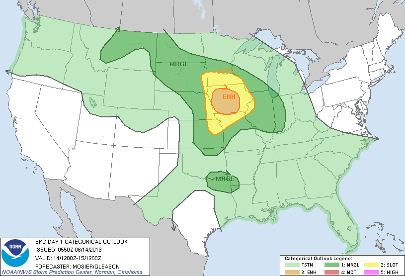
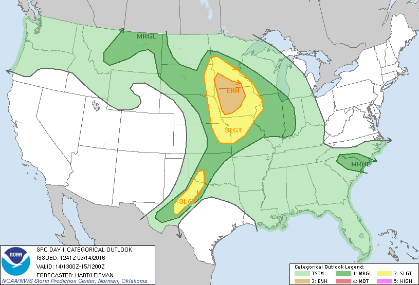
SPC 1300Z Day 1 Outlook DAY 1 CONVECTIVE OUTLOOK NWS STORM PREDICTION CENTER NORMAN OK 0741 AM CDT TUE JUN 14 2016 VALID 141300Z – 151200Z …THERE IS AN ENH RISK OF SEVERE THUNDERSTORMS OVER PARTS OF SOUTHERN MN AND WESTERN/CENTRAL IA… …THERE IS A SLGT RISK OF SEVERE THUNDERSTORMS OVER PARTS OF THE MIDWEST STATES AND UPPER MS VALLEY…… Read more →

Posted in Archive, Severe Weather Discussions | Tagged Severe Weather, weather
Storm Prediction Center Jun 14, 2016 Early Morning UTC Day 1 Convective Outlook

Storm Prediction Center Jun 14, 2016 Early Morning UTC Day 1 Convective Outlook

Alomar Sharpe Tuesday, June 14, 2016 // 1:38 am

SPC 1200Z Day 1 Outlook DAY 1 CONVECTIVE OUTLOOK NWS STORM PREDICTION CENTER NORMAN OK 1250 AM CDT TUE JUN 14 2016 VALID 141200Z – 151200Z …THERE IS AN ENH RISK OF SEVERE THUNDERSTORMS ACROSS CNTRL IA… …THERE IS A SLGT RISK OF SEVERE THUNDERSTORMS SURROUNDING THE ENH RISK OVER PORTIONS OF THE UPPER AND MID MS VALLEYS… …THERE IS… Read more →

Posted in Archive, Severe Weather Discussions | Tagged Severe Weather, weather

NOAA Storm Prediction Center Tornado Watch 252

Alomar Sharpe Monday, June 13, 2016 // 11:34 pm

WW 252 TORNADO OK TX 132330Z – 140700Z URGENT – IMMEDIATE BROADCAST REQUESTED TORNADO WATCH NUMBER 252 NWS STORM PREDICTION CENTER NORMAN OK 630 PM CDT MON JUN 13 2016 THE NWS STORM PREDICTION CENTER HAS ISSUED A * TORNADO WATCH FOR PORTIONS OF THE OKLAHOMA PANHANDLE THE TEXAS PANHANDLE AND NORTHERN PARTS OF THE TEXAS SOUTH PLAINS * EFFECTIVE… Read more →

Posted in Archive, Severe Weather Discussions | Tagged Severe Weather, Watches and Warnings, weather

NOAA Storm Prediction Center Severe Thunderstorm Watch 253 Status Reports

Alomar Sharpe Monday, June 13, 2016 // 11:34 pm

WW 0253 Status Updates STATUS REPORT ON WW 253 SEVERE WEATHER THREAT CONTINUES RIGHT OF A LINE FROM 30 SW GAG TO 10 WSW GAG TO 40 SSW AVK. FOR ADDITIONAL INFORMATION SEE MESOSCALE DISCUSSION 0909 ..COHEN..06/14/16 ATTN…WFO…DDC…GLD…OUN… STATUS REPORT FOR WS 253 SEVERE WEATHER THREAT CONTINUES FOR THE FOLLOWING AREAS OKC045-129-140540- OK . OKLAHOMA COUNTIES INCLUDED ARE ELLIS ROGER… Read more →

Posted in Archive, Severe Weather Discussions | Tagged Severe Weather, Watches and Warnings, weather
NOAA Storm Prediction Center Mesoscale Discussion 911

NOAA Storm Prediction Center Mesoscale Discussion 911

Alomar Sharpe Monday, June 13, 2016 // 11:27 pm

MD 0911 CONCERNING SEVERE POTENTIAL…WATCH UNLIKELY FOR PORTIONS OF WRN/CNTRL NEB…NWRN KS…ERN CO MESOSCALE DISCUSSION 0911 NWS STORM PREDICTION CENTER NORMAN OK 1126 PM CDT MON JUN 13 2016 AREAS AFFECTED…PORTIONS OF WRN/CNTRL NEB…NWRN KS…ERN CO CONCERNING…SEVERE POTENTIAL…WATCH UNLIKELY VALID 140426Z – 140630Z PROBABILITY OF WATCH ISSUANCE…5 PERCENT SUMMARY…TSTMS SPREADING ACROSS PORTIONS OF THE CNTRL GREAT PLAINS DURING THE OVERNIGHT… Read more →

Posted in Archive, Severe Weather Discussions | Tagged Severe Weather, Watches and Warnings, weather
← Previous 1 … 396 397 398 … 2,028 Next →

Today’s Severe Weather Threat

SVR WX THREAT

Today’s Tornado Threat

SVR WX THREAT

Search The Site

Contributing Scientists

  • Alomar Sharpe
  • Amber Kulick
  • Branden Walker
  • Chris Vagasky
  • Colt Murray
  • Emily Riter
  • Kendall Junker
  • Matt Breland
  • Nick Lilja
  • NickelBlock Staff
  • Noah Gower

Wx Topics

2019 Atlantic Hurricane Season 2020 Atlantic hurricane Season Alabama Weather Amarillo weather Atlantic Hurricane Season Coronavirus COVID-19 COVID19 Earthquakes Flooding Geology Gulf Coast Weather hail hurricanes Louisiana Weather Mississippi Weather rain Severe Weather snow Texas Weather Thunderstorms Tornadoes Tropical Depressions Tropical Storms Tropical Weather tropics USGS Watches and Warnings weather Wind

What We Cover

  • Archive (10,136)
  • Climate (64)
  • Education (230)
  • Environment (8)
  • Forecasting (467)
  • Geology (210)
  • High Plains Weather (119)
  • Midwest Weather (35)
  • Northeast Weather (13)
  • Northwest Weather (5)
  • Not Weather (93)
  • Research (31)
  • River Flooding (23)
  • Severe Weather Discussions (8,640)
  • South Plains Weather (69)
  • Southeast Weather (312)
  • Space (19)
  • Storm Chasing (86)
  • Tropics (450)
  • Weather & Sports (4)
  • Weather & TV (37)
  • Weather History (8)
  • West Coast Weather (4)

Research

  • Conclusion: How multiple variables control TX/OK panhandle Spring severe weather
  • Findings: How multiple variables control TX/OK panhandle Spring severe weather
  • Methods: How multiple variables control TX/OK panhandle Spring severe weather
  • Introduction: How multiple variables control TX/OK panhandle Spring severe weather
  • Works Cited: How multiple variables control TX/OK panhandle Spring severe weather

Popular This Month

  • Remember that “Arctic Blast” people were posting about? Buckle up (6,957)
  • Another “Arctic Blast!” headed to the southeast says social media-rologists (2,420)
  • Arctic blast plunges Mississippi into ice age-like conditions colder than one of the moons of Jupiter (2,410)
  • More cold and snow has South Mississippi feeling like South Manitoba (1,888)
  • More wintry weather possible in South Mississippi next week (1,854)
  • Enough with the “Meteorologists get paid to be wrong” (1,617)
  • Afternoon Update: Snow possible for South Mississippi (960)
  • CIPS Analogs showing thunderstorms, possible severe weather, late next week for south Mississippi (949)
  • Freezing weather won’t kill all mosquitos (664)
  • Jan 16, south Mississippi morning snowfall update (541)
  • Instantly freeze water to make stalagmites (333)
  • Will it snow? A brief look at the steps to get it (318)

Primary Menu

  • About us
    • About us
    • How We Forecast
    • Archives
  • Our Services
    • Live Stream: Severe Weather Discussions
    • Go Storm Chasing
    • Pictures
  • Contact Us!
  • Jobs
  • Weather Safety
    • Weather Safety
    • Hurricane Preparedness Tips
    • Road Conditions
    • Current Conditions
    • South Mississippi river forecasts
    • Forecasting Presentation
  • Login

Secondary Menu

  • Severe Weather Outlook
    • Severe Outlook through Day 8
    • Severe Outlook By State
    • Today’s Severe Weather Threat
    • Today’s Tornado Threat
    • Today’s Severe Wind Threat
    • Today’s Severe Hail Threat
    • Excessive Rainfall Forecasts
  • Short Term Forecast
    • Current Radar & Satellite
    • Detailed National Forecast Discussion
    • National Surface Maps
    • National Temperatures
    • National Precipitation Chances
    • National Precipitation Estimates
    • National Snowfall Estimates
    • National Ice Estimates
    • National Convective Outlook
    • Public RAPTOR Map
    • Model Data Viewer
  • Tropics
  • 10 Day Trend
  • Seasonal Discussion

Copyright © 2026 NickelBlock Forecasting.

Powered by WordPress and Path. Back to Top

Google+
  • About us
  • Our Services
  • Contact Us!
  • Jobs
  • Weather Safety
  • Login