Primary Menu Search
  • About us
    • About us
    • How We Forecast
    • Archives
  • Our Services
    • Live Stream: Severe Weather Discussions
    • Go Storm Chasing
    • Pictures
  • Contact Us!
  • Jobs
  • Weather Safety
    • Weather Safety
    • Hurricane Preparedness Tips
    • Road Conditions
    • Current Conditions
    • South Mississippi river forecasts
    • Forecasting Presentation
  • Login

NickelBlock Forecasting

Funny name. Serious data.

Secondary Menu
  • Severe Weather Outlook
    • Severe Outlook through Day 8
    • Severe Outlook By State
    • Today’s Severe Weather Threat
    • Today’s Tornado Threat
    • Today’s Severe Wind Threat
    • Today’s Severe Hail Threat
    • Excessive Rainfall Forecasts
  • Short Term Forecast
    • Current Radar & Satellite
    • Detailed National Forecast Discussion
    • National Surface Maps
    • National Temperatures
    • National Precipitation Chances
    • National Precipitation Estimates
    • National Snowfall Estimates
    • National Ice Estimates
    • National Convective Outlook
    • Public RAPTOR Map
    • Model Data Viewer
  • Tropics
  • 10 Day Trend
  • Seasonal Discussion
You are here: Home ∼ Page 392

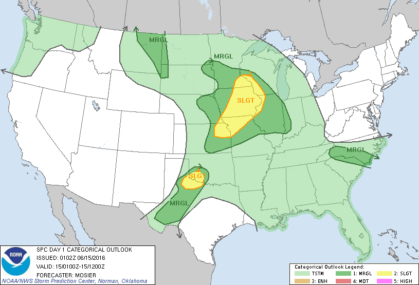
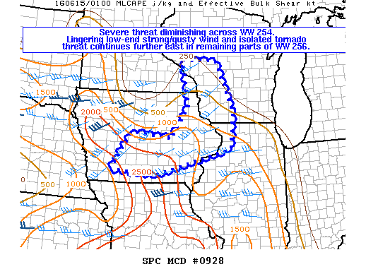
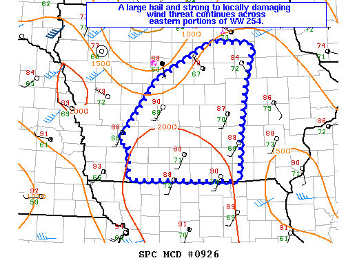
NOAA Storm Prediction Center Severe Thunderstorm Watch 256

Alomar Sharpe Tuesday, June 14, 2016 // 9:37 pm

WW 256 SEVERE TSTM IA IL MN WI 142105Z – 150400Z URGENT – IMMEDIATE BROADCAST REQUESTED SEVERE THUNDERSTORM WATCH NUMBER 256 NWS STORM PREDICTION CENTER NORMAN OK 405 PM CDT TUE JUN 14 2016 THE NWS STORM PREDICTION CENTER HAS ISSUED A * SEVERE THUNDERSTORM WATCH FOR PORTIONS OF EASTERN IOWA FAR NORTHWEST ILLINOIS SOUTHEAST MINNESOTA WESTERN WISCONSIN * EFFECTIVE… Read more →

Posted in Archive, Severe Weather Discussions | Tagged Severe Weather, Watches and Warnings, weather
Storm Prediction Center Jun 15, 2016 UTC Evening Outlook

Storm Prediction Center Jun 15, 2016 UTC Evening Outlook

Alomar Sharpe Tuesday, June 14, 2016 // 8:38 pm

SPC 0100Z Day 1 Outlook DAY 1 CONVECTIVE OUTLOOK NWS STORM PREDICTION CENTER NORMAN OK 0802 PM CDT TUE JUN 14 2016 VALID 150100Z – 151200Z …THERE IS A SLGT RISK OF SEVERE THUNDERSTORMS ACROSS PORTIONS OF THE UPPER AND MID MS VALLEYS… …THERE IS A SLGT RISK OF SEVERE THUNDERSTORMS ACROSS NW TX AND FAR SW OK… …THERE IS… Read more →

Posted in Archive, Severe Weather Discussions | Tagged Severe Weather, weather
NOAA Storm Prediction Center Mesoscale Discussion 928

NOAA Storm Prediction Center Mesoscale Discussion 928

Alomar Sharpe Tuesday, June 14, 2016 // 8:37 pm

MD 0928 CONCERNING SEVERE THUNDERSTORM WATCH 254…256… FOR PORTIONS OF CNTRL/ERN IA…FAR SERN MN…SWRN WI…AND NWRN IL MESOSCALE DISCUSSION 0928 NWS STORM PREDICTION CENTER NORMAN OK 0836 PM CDT TUE JUN 14 2016 AREAS AFFECTED…PORTIONS OF CNTRL/ERN IA…FAR SERN MN…SWRN WI…AND NWRN IL CONCERNING…SEVERE THUNDERSTORM WATCH 254…256… VALID 150136Z – 150300Z THE SEVERE WEATHER THREAT FOR SEVERE THUNDERSTORM WATCH 254…256…CONTINUES…. Read more →

Posted in Archive, Severe Weather Discussions | Tagged Severe Weather, Watches and Warnings, weather
NOAA Storm Prediction Center Mesoscale Discussion 927

NOAA Storm Prediction Center Mesoscale Discussion 927

Alomar Sharpe Tuesday, June 14, 2016 // 7:19 pm

MD 0927 CONCERNING SEVERE POTENTIAL…WATCH UNLIKELY FOR PORTIONS OF CNTRL IL MESOSCALE DISCUSSION 0927 NWS STORM PREDICTION CENTER NORMAN OK 0718 PM CDT TUE JUN 14 2016 AREAS AFFECTED…PORTIONS OF CNTRL IL CONCERNING…SEVERE POTENTIAL…WATCH UNLIKELY VALID 150018Z – 150215Z PROBABILITY OF WATCH ISSUANCE…20 PERCENT SUMMARY…A RISK FOR STRONG TSTMS WILL AFFECT PORTIONS OF CNTRL IL INTO THE EVENING HOURS. WHILE… Read more →

Posted in Archive, Severe Weather Discussions | Tagged Severe Weather, Watches and Warnings, weather
NOAA Storm Prediction Center Mesoscale Discussion 926

NOAA Storm Prediction Center Mesoscale Discussion 926

Alomar Sharpe Tuesday, June 14, 2016 // 7:01 pm

MD 0926 CONCERNING SEVERE THUNDERSTORM WATCH 254… FOR PORTIONS OF CNTRL/ERN IA MESOSCALE DISCUSSION 0926 NWS STORM PREDICTION CENTER NORMAN OK 0700 PM CDT TUE JUN 14 2016 AREAS AFFECTED…PORTIONS OF CNTRL/ERN IA CONCERNING…SEVERE THUNDERSTORM WATCH 254… VALID 150000Z – 150100Z THE SEVERE WEATHER THREAT FOR SEVERE THUNDERSTORM WATCH 254 CONTINUES. SUMMARY…A LARGE HAIL AND STRONG TO LOCALLY DAMAGING WIND… Read more →

Posted in Archive, Severe Weather Discussions | Tagged Severe Weather, Watches and Warnings, weather
← Previous 1 … 391 392 393 … 2,028 Next →

Today’s Severe Weather Threat

SVR WX THREAT

Today’s Tornado Threat

SVR WX THREAT

Search The Site

Contributing Scientists

  • Alomar Sharpe
  • Amber Kulick
  • Branden Walker
  • Chris Vagasky
  • Colt Murray
  • Emily Riter
  • Kendall Junker
  • Matt Breland
  • Nick Lilja
  • NickelBlock Staff
  • Noah Gower

Wx Topics

2019 Atlantic Hurricane Season 2020 Atlantic hurricane Season Alabama Weather Amarillo weather Atlantic Hurricane Season Coronavirus COVID-19 COVID19 Earthquakes Flooding Geology Gulf Coast Weather hail hurricanes Louisiana Weather Mississippi Weather rain Severe Weather snow Texas Weather Thunderstorms Tornadoes Tropical Depressions Tropical Storms Tropical Weather tropics USGS Watches and Warnings weather Wind

What We Cover

  • Archive (10,136)
  • Climate (64)
  • Education (230)
  • Environment (8)
  • Forecasting (467)
  • Geology (210)
  • High Plains Weather (119)
  • Midwest Weather (35)
  • Northeast Weather (13)
  • Northwest Weather (5)
  • Not Weather (93)
  • Research (31)
  • River Flooding (23)
  • Severe Weather Discussions (8,640)
  • South Plains Weather (69)
  • Southeast Weather (312)
  • Space (19)
  • Storm Chasing (86)
  • Tropics (450)
  • Weather & Sports (4)
  • Weather & TV (37)
  • Weather History (8)
  • West Coast Weather (4)

Research

  • Conclusion: How multiple variables control TX/OK panhandle Spring severe weather
  • Findings: How multiple variables control TX/OK panhandle Spring severe weather
  • Methods: How multiple variables control TX/OK panhandle Spring severe weather
  • Introduction: How multiple variables control TX/OK panhandle Spring severe weather
  • Works Cited: How multiple variables control TX/OK panhandle Spring severe weather

Popular This Month

  • Remember that “Arctic Blast” people were posting about? Buckle up (6,957)
  • Another “Arctic Blast!” headed to the southeast says social media-rologists (2,420)
  • Arctic blast plunges Mississippi into ice age-like conditions colder than one of the moons of Jupiter (2,410)
  • More cold and snow has South Mississippi feeling like South Manitoba (1,888)
  • More wintry weather possible in South Mississippi next week (1,854)
  • Enough with the “Meteorologists get paid to be wrong” (1,617)
  • Afternoon Update: Snow possible for South Mississippi (960)
  • CIPS Analogs showing thunderstorms, possible severe weather, late next week for south Mississippi (949)
  • Freezing weather won’t kill all mosquitos (664)
  • Jan 16, south Mississippi morning snowfall update (541)
  • Instantly freeze water to make stalagmites (333)
  • Will it snow? A brief look at the steps to get it (318)

Primary Menu

  • About us
    • About us
    • How We Forecast
    • Archives
  • Our Services
    • Live Stream: Severe Weather Discussions
    • Go Storm Chasing
    • Pictures
  • Contact Us!
  • Jobs
  • Weather Safety
    • Weather Safety
    • Hurricane Preparedness Tips
    • Road Conditions
    • Current Conditions
    • South Mississippi river forecasts
    • Forecasting Presentation
  • Login

Secondary Menu

  • Severe Weather Outlook
    • Severe Outlook through Day 8
    • Severe Outlook By State
    • Today’s Severe Weather Threat
    • Today’s Tornado Threat
    • Today’s Severe Wind Threat
    • Today’s Severe Hail Threat
    • Excessive Rainfall Forecasts
  • Short Term Forecast
    • Current Radar & Satellite
    • Detailed National Forecast Discussion
    • National Surface Maps
    • National Temperatures
    • National Precipitation Chances
    • National Precipitation Estimates
    • National Snowfall Estimates
    • National Ice Estimates
    • National Convective Outlook
    • Public RAPTOR Map
    • Model Data Viewer
  • Tropics
  • 10 Day Trend
  • Seasonal Discussion

Copyright © 2026 NickelBlock Forecasting.

Powered by WordPress and Path. Back to Top

Google+
  • About us
  • Our Services
  • Contact Us!
  • Jobs
  • Weather Safety
  • Login