Primary Menu Search
  • About us
    • About us
    • How We Forecast
    • Archives
  • Our Services
    • Live Stream: Severe Weather Discussions
    • Go Storm Chasing
    • Pictures
  • Contact Us!
  • Jobs
  • Weather Safety
    • Weather Safety
    • Hurricane Preparedness Tips
    • Road Conditions
    • Current Conditions
    • South Mississippi river forecasts
    • Forecasting Presentation
  • Login

NickelBlock Forecasting

Funny name. Serious data.

Secondary Menu
  • Severe Weather Outlook
    • Severe Outlook through Day 8
    • Severe Outlook By State
    • Today’s Severe Weather Threat
    • Today’s Tornado Threat
    • Today’s Severe Wind Threat
    • Today’s Severe Hail Threat
    • Excessive Rainfall Forecasts
  • Short Term Forecast
    • Current Radar & Satellite
    • Detailed National Forecast Discussion
    • National Surface Maps
    • National Temperatures
    • National Precipitation Chances
    • National Precipitation Estimates
    • National Snowfall Estimates
    • National Ice Estimates
    • National Convective Outlook
    • Public RAPTOR Map
    • Model Data Viewer
  • Tropics
  • 10 Day Trend
  • Seasonal Discussion
You are here: Home ∼ Page 391
Storm Prediction Center Jun 15, 2016 Morning Outlook

Storm Prediction Center Jun 15, 2016 Morning Outlook

Alomar Sharpe Wednesday, June 15, 2016 // 8:38 am

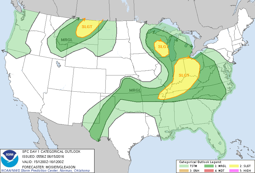
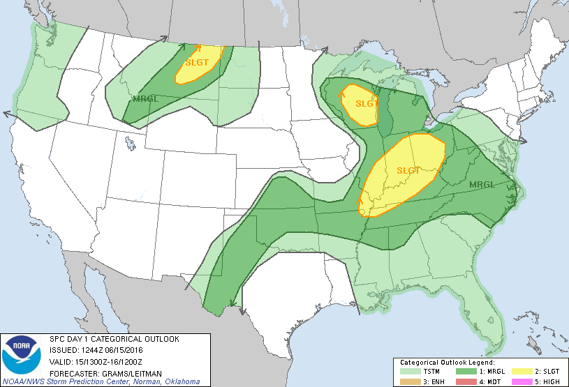
SPC 1300Z Day 1 Outlook DAY 1 CONVECTIVE OUTLOOK NWS STORM PREDICTION CENTER NORMAN OK 0744 AM CDT WED JUN 15 2016 VALID 151300Z – 161200Z …THERE IS A SLGT RISK OF SEVERE THUNDERSTORMS WI… …THERE IS A SLGT RISK OF SEVERE THUNDERSTORMS OH TO MID-MS VALLEY… …THERE IS A SLGT RISK OF SEVERE THUNDERSTORMS ERN MT… …THERE IS A… Read more →

Posted in Archive, Severe Weather Discussions | Tagged Severe Weather, weather
Storm Prediction Center Jun 15, 2016 Early Morning UTC Day 1 Convective Outlook

Storm Prediction Center Jun 15, 2016 Early Morning UTC Day 1 Convective Outlook

Alomar Sharpe Wednesday, June 15, 2016 // 1:38 am

SPC 1200Z Day 1 Outlook DAY 1 CONVECTIVE OUTLOOK NWS STORM PREDICTION CENTER NORMAN OK 1256 AM CDT WED JUN 15 2016 VALID 151200Z – 161200Z …THERE IS A SLGT RISK OF SEVERE THUNDERSTORMS OVER ERN MT… …THERE IS A SLGT RISK OF SEVERE THUNDERSTORMS OVER CNTRL/SRN WI… …THERE IS A SLGT RISK OF SEVERE THUNDERSTORMS OVER PORTIONS OF OH… Read more →

Posted in Archive, Severe Weather Discussions | Tagged Severe Weather, weather
NOAA Storm Prediction Center Mesoscale Discussion 930

NOAA Storm Prediction Center Mesoscale Discussion 930

Alomar Sharpe Tuesday, June 14, 2016 // 11:28 pm

MD 0930 CONCERNING SEVERE POTENTIAL…WATCH UNLIKELY FOR PORTIONS OF NRN IL MESOSCALE DISCUSSION 0930 NWS STORM PREDICTION CENTER NORMAN OK 1127 PM CDT TUE JUN 14 2016 AREAS AFFECTED…PORTIONS OF NRN IL CONCERNING…SEVERE POTENTIAL…WATCH UNLIKELY VALID 150427Z – 150600Z PROBABILITY OF WATCH ISSUANCE…5 PERCENT SUMMARY…TSTMS CROSSING PARTS OF NRN IL OVERNIGHT MAY PRODUCE LOCALLY STRONG WIND GUSTS. AN ISOLATED DMGG… Read more →

Posted in Archive, Severe Weather Discussions | Tagged Severe Weather, Watches and Warnings, weather

NOAA Storm Prediction Center Tornado Watch 257 Status Reports

Alomar Sharpe Tuesday, June 14, 2016 // 9:44 pm

WW 0257 Status Updates STATUS REPORT ON WW 257 SEVERE WEATHER THREAT CONTINUES RIGHT OF A LINE FROM 70 S CDS TO 40 S CDS TO 55 SE CDS TO 65 WSW SPS. FOR ADDITIONAL INFORMATION SEE MESOSCALE DISCUSSION 0929 ..COHEN..06/15/16 ATTN…WFO…OUN…LUB… STATUS REPORT FOR WT 257 SEVERE WEATHER THREAT CONTINUES FOR THE FOLLOWING AREAS TXC269-275-150340- TX . TEXAS COUNTIES… Read more →

Posted in Archive, Severe Weather Discussions | Tagged Severe Weather, Watches and Warnings, weather
NOAA Storm Prediction Center Mesoscale Discussion 929

NOAA Storm Prediction Center Mesoscale Discussion 929

Alomar Sharpe Tuesday, June 14, 2016 // 9:40 pm

MD 0929 CONCERNING TORNADO WATCH 257… FOR A SMALL PART OF WRN N TX MESOSCALE DISCUSSION 0929 NWS STORM PREDICTION CENTER NORMAN OK 0939 PM CDT TUE JUN 14 2016 AREAS AFFECTED…A SMALL PART OF WRN N TX CONCERNING…TORNADO WATCH 257… VALID 150239Z – 150415Z THE SEVERE WEATHER THREAT FOR TORNADO WATCH 257 CONTINUES. SUMMARY…THE SVR RISK IN WW 257… Read more →

Posted in Archive, Severe Weather Discussions | Tagged Severe Weather, Watches and Warnings, weather
← Previous 1 … 390 391 392 … 2,028 Next →

Today’s Severe Weather Threat

SVR WX THREAT

Today’s Tornado Threat

SVR WX THREAT

Search The Site

Contributing Scientists

  • Alomar Sharpe
  • Amber Kulick
  • Branden Walker
  • Chris Vagasky
  • Colt Murray
  • Emily Riter
  • Kendall Junker
  • Matt Breland
  • Nick Lilja
  • NickelBlock Staff
  • Noah Gower

Wx Topics

2019 Atlantic Hurricane Season 2020 Atlantic hurricane Season Alabama Weather Amarillo weather Atlantic Hurricane Season Coronavirus COVID-19 COVID19 Earthquakes Flooding Geology Gulf Coast Weather hail hurricanes Louisiana Weather Mississippi Weather rain Severe Weather snow Texas Weather Thunderstorms Tornadoes Tropical Depressions Tropical Storms Tropical Weather tropics USGS Watches and Warnings weather Wind

What We Cover

  • Archive (10,136)
  • Climate (64)
  • Education (230)
  • Environment (8)
  • Forecasting (467)
  • Geology (210)
  • High Plains Weather (119)
  • Midwest Weather (35)
  • Northeast Weather (13)
  • Northwest Weather (5)
  • Not Weather (93)
  • Research (31)
  • River Flooding (23)
  • Severe Weather Discussions (8,640)
  • South Plains Weather (69)
  • Southeast Weather (312)
  • Space (19)
  • Storm Chasing (86)
  • Tropics (450)
  • Weather & Sports (4)
  • Weather & TV (37)
  • Weather History (8)
  • West Coast Weather (4)

Research

  • Conclusion: How multiple variables control TX/OK panhandle Spring severe weather
  • Findings: How multiple variables control TX/OK panhandle Spring severe weather
  • Methods: How multiple variables control TX/OK panhandle Spring severe weather
  • Introduction: How multiple variables control TX/OK panhandle Spring severe weather
  • Works Cited: How multiple variables control TX/OK panhandle Spring severe weather

Popular This Month

  • Remember that “Arctic Blast” people were posting about? Buckle up (6,957)
  • Another “Arctic Blast!” headed to the southeast says social media-rologists (2,420)
  • Arctic blast plunges Mississippi into ice age-like conditions colder than one of the moons of Jupiter (2,410)
  • More cold and snow has South Mississippi feeling like South Manitoba (1,888)
  • More wintry weather possible in South Mississippi next week (1,854)
  • Enough with the “Meteorologists get paid to be wrong” (1,617)
  • Afternoon Update: Snow possible for South Mississippi (960)
  • CIPS Analogs showing thunderstorms, possible severe weather, late next week for south Mississippi (949)
  • Freezing weather won’t kill all mosquitos (664)
  • Jan 16, south Mississippi morning snowfall update (541)
  • Instantly freeze water to make stalagmites (333)
  • Will it snow? A brief look at the steps to get it (318)

Primary Menu

  • About us
    • About us
    • How We Forecast
    • Archives
  • Our Services
    • Live Stream: Severe Weather Discussions
    • Go Storm Chasing
    • Pictures
  • Contact Us!
  • Jobs
  • Weather Safety
    • Weather Safety
    • Hurricane Preparedness Tips
    • Road Conditions
    • Current Conditions
    • South Mississippi river forecasts
    • Forecasting Presentation
  • Login

Secondary Menu

  • Severe Weather Outlook
    • Severe Outlook through Day 8
    • Severe Outlook By State
    • Today’s Severe Weather Threat
    • Today’s Tornado Threat
    • Today’s Severe Wind Threat
    • Today’s Severe Hail Threat
    • Excessive Rainfall Forecasts
  • Short Term Forecast
    • Current Radar & Satellite
    • Detailed National Forecast Discussion
    • National Surface Maps
    • National Temperatures
    • National Precipitation Chances
    • National Precipitation Estimates
    • National Snowfall Estimates
    • National Ice Estimates
    • National Convective Outlook
    • Public RAPTOR Map
    • Model Data Viewer
  • Tropics
  • 10 Day Trend
  • Seasonal Discussion

Copyright © 2026 NickelBlock Forecasting.

Powered by WordPress and Path. Back to Top

Google+
  • About us
  • Our Services
  • Contact Us!
  • Jobs
  • Weather Safety
  • Login