Primary Menu Search
  • About us
    • About us
    • How We Forecast
    • Archives
  • Our Services
    • Live Stream: Severe Weather Discussions
    • Go Storm Chasing
    • Pictures
  • Contact Us!
  • Jobs
  • Weather Safety
    • Weather Safety
    • Hurricane Preparedness Tips
    • Road Conditions
    • Current Conditions
    • South Mississippi river forecasts
    • Forecasting Presentation
  • Login

NickelBlock Forecasting

Funny name. Serious data.

Secondary Menu
  • Severe Weather Outlook
    • Severe Outlook through Day 8
    • Severe Outlook By State
    • Today’s Severe Weather Threat
    • Today’s Tornado Threat
    • Today’s Severe Wind Threat
    • Today’s Severe Hail Threat
    • Excessive Rainfall Forecasts
  • Short Term Forecast
    • Current Radar & Satellite
    • Detailed National Forecast Discussion
    • National Surface Maps
    • National Temperatures
    • National Precipitation Chances
    • National Precipitation Estimates
    • National Snowfall Estimates
    • National Ice Estimates
    • National Convective Outlook
    • Public RAPTOR Map
    • Model Data Viewer
  • Tropics
  • 10 Day Trend
  • Seasonal Discussion
You are here: Home ∼ Page 329

NOAA Storm Prediction Center Severe Thunderstorm Watch 310

Alomar Sharpe Wednesday, June 29, 2016 // 3:40 pm

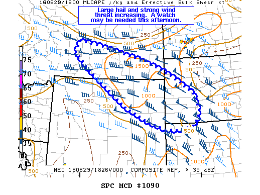
WW 310 SEVERE TSTM SD 292040Z – 300200Z URGENT – IMMEDIATE BROADCAST REQUESTED SEVERE THUNDERSTORM WATCH NUMBER 310 NWS STORM PREDICTION CENTER NORMAN OK 240 PM MDT WED JUN 29 2016 THE NWS STORM PREDICTION CENTER HAS ISSUED A * SEVERE THUNDERSTORM WATCH FOR PORTIONS OF NORTHWEST SOUTH DAKOTA * EFFECTIVE THIS WEDNESDAY AFTERNOON AND EVENING FROM 240 PM UNTIL… Read more →

Posted in Archive, Severe Weather Discussions | Tagged Severe Weather, Watches and Warnings, weather
NOAA Storm Prediction Center Mesoscale Discussion 1090

NOAA Storm Prediction Center Mesoscale Discussion 1090

Alomar Sharpe Wednesday, June 29, 2016 // 1:48 pm

MD 1090 CONCERNING SEVERE POTENTIAL…WATCH POSSIBLE FOR SE MT…NE WY…SW SD MESOSCALE DISCUSSION 1090 NWS STORM PREDICTION CENTER NORMAN OK 0147 PM CDT WED JUN 29 2016 AREAS AFFECTED…SE MT…NE WY…SW SD CONCERNING…SEVERE POTENTIAL…WATCH POSSIBLE VALID 291847Z – 292015Z PROBABILITY OF WATCH ISSUANCE…40 PERCENT SUMMARY…ISOLATED LARGE HAIL AND DAMAGING WIND GUSTS WILL BE POSSIBLE THROUGH THE AFTERNOON. A WATCH MAY… Read more →

Posted in Archive, Severe Weather Discussions | Tagged Severe Weather, Watches and Warnings, weather
NOAA Storm Prediction Center Mesoscale Discussion 1089

NOAA Storm Prediction Center Mesoscale Discussion 1089

Alomar Sharpe Wednesday, June 29, 2016 // 1:14 pm

MD 1089 CONCERNING SEVERE POTENTIAL…WATCH UNLIKELY FOR PORTIONS OF SE MT…SW INTO CENTRAL ND…NW SD MESOSCALE DISCUSSION 1089 NWS STORM PREDICTION CENTER NORMAN OK 0113 PM CDT WED JUN 29 2016 AREAS AFFECTED…PORTIONS OF SE MT…SW INTO CENTRAL ND…NW SD CONCERNING…SEVERE POTENTIAL…WATCH UNLIKELY VALID 291813Z – 291945Z PROBABILITY OF WATCH ISSUANCE…20 PERCENT SUMMARY…WIDELY SCATTERED THUNDERSTORMS MAY PRODUCE PERIODIC GUSTY WINDS… Read more →

Posted in Archive, Severe Weather Discussions | Tagged Severe Weather, Watches and Warnings, weather
NOAA Storm Prediction Center Mesoscale Discussion 1088

NOAA Storm Prediction Center Mesoscale Discussion 1088

Alomar Sharpe Wednesday, June 29, 2016 // 11:09 am

MD 1088 CONCERNING SEVERE POTENTIAL…WATCH UNLIKELY FOR WRN/NRN NEW ENGLAND MESOSCALE DISCUSSION 1088 NWS STORM PREDICTION CENTER NORMAN OK 1108 AM CDT WED JUN 29 2016 AREAS AFFECTED…WRN/NRN NEW ENGLAND CONCERNING…SEVERE POTENTIAL…WATCH UNLIKELY VALID 291608Z – 291715Z PROBABILITY OF WATCH ISSUANCE…5 PERCENT SUMMARY…CONVECTION WILL GRADUALLY INCREASE IN AREAL COVERAGE AND INTENSITY OVER INTO THE MID AFTERNOON HOURS. SMALL HAIL OR… Read more →

Posted in Archive, Severe Weather Discussions | Tagged Severe Weather, Watches and Warnings, weather
Storm Prediction Center Jun 29, 2016 Morning Outlook

Storm Prediction Center Jun 29, 2016 Morning Outlook

Alomar Sharpe Wednesday, June 29, 2016 // 8:38 am

SPC 1300Z Day 1 Outlook DAY 1 CONVECTIVE OUTLOOK NWS STORM PREDICTION CENTER NORMAN OK 0743 AM CDT WED JUN 29 2016 VALID 291300Z – 301200Z …THERE IS A SLGT RISK OF SEVERE THUNDERSTORMS THIS AFTERNOON INTO TONIGHT FOR PARTS OF THE NRN/CENTRAL HIGH PLAINS… …THERE IS A MRGL RISK OF SEVERE THUNDERSTORMS SURROUNDING THE SLIGHT RISK…FROM THE HIGH PLAINS… Read more →

Posted in Archive, Severe Weather Discussions | Tagged Severe Weather, weather
← Previous 1 … 328 329 330 … 2,028 Next →

Today’s Severe Weather Threat

SVR WX THREAT

Today’s Tornado Threat

SVR WX THREAT

Search The Site

Contributing Scientists

  • Alomar Sharpe
  • Amber Kulick
  • Branden Walker
  • Chris Vagasky
  • Colt Murray
  • Emily Riter
  • Kendall Junker
  • Matt Breland
  • Nick Lilja
  • NickelBlock Staff
  • Noah Gower

Wx Topics

2019 Atlantic Hurricane Season 2020 Atlantic hurricane Season Alabama Weather Amarillo weather Atlantic Hurricane Season Coronavirus COVID-19 COVID19 Earthquakes Flooding Geology Gulf Coast Weather hail hurricanes Louisiana Weather Mississippi Weather rain Severe Weather snow Texas Weather Thunderstorms Tornadoes Tropical Depressions Tropical Storms Tropical Weather tropics USGS Watches and Warnings weather Wind

What We Cover

  • Archive (10,136)
  • Climate (64)
  • Education (230)
  • Environment (8)
  • Forecasting (467)
  • Geology (210)
  • High Plains Weather (119)
  • Midwest Weather (35)
  • Northeast Weather (13)
  • Northwest Weather (5)
  • Not Weather (93)
  • Research (31)
  • River Flooding (23)
  • Severe Weather Discussions (8,640)
  • South Plains Weather (69)
  • Southeast Weather (312)
  • Space (19)
  • Storm Chasing (86)
  • Tropics (450)
  • Weather & Sports (4)
  • Weather & TV (37)
  • Weather History (8)
  • West Coast Weather (4)

Research

  • Conclusion: How multiple variables control TX/OK panhandle Spring severe weather
  • Findings: How multiple variables control TX/OK panhandle Spring severe weather
  • Methods: How multiple variables control TX/OK panhandle Spring severe weather
  • Introduction: How multiple variables control TX/OK panhandle Spring severe weather
  • Works Cited: How multiple variables control TX/OK panhandle Spring severe weather

Popular This Month

  • Remember that “Arctic Blast” people were posting about? Buckle up (6,957)
  • Another “Arctic Blast!” headed to the southeast says social media-rologists (2,420)
  • Arctic blast plunges Mississippi into ice age-like conditions colder than one of the moons of Jupiter (2,410)
  • More cold and snow has South Mississippi feeling like South Manitoba (1,888)
  • More wintry weather possible in South Mississippi next week (1,854)
  • Enough with the “Meteorologists get paid to be wrong” (1,617)
  • Afternoon Update: Snow possible for South Mississippi (960)
  • CIPS Analogs showing thunderstorms, possible severe weather, late next week for south Mississippi (949)
  • Freezing weather won’t kill all mosquitos (664)
  • Jan 16, south Mississippi morning snowfall update (541)
  • Instantly freeze water to make stalagmites (333)
  • Will it snow? A brief look at the steps to get it (318)

Primary Menu

  • About us
    • About us
    • How We Forecast
    • Archives
  • Our Services
    • Live Stream: Severe Weather Discussions
    • Go Storm Chasing
    • Pictures
  • Contact Us!
  • Jobs
  • Weather Safety
    • Weather Safety
    • Hurricane Preparedness Tips
    • Road Conditions
    • Current Conditions
    • South Mississippi river forecasts
    • Forecasting Presentation
  • Login

Secondary Menu

  • Severe Weather Outlook
    • Severe Outlook through Day 8
    • Severe Outlook By State
    • Today’s Severe Weather Threat
    • Today’s Tornado Threat
    • Today’s Severe Wind Threat
    • Today’s Severe Hail Threat
    • Excessive Rainfall Forecasts
  • Short Term Forecast
    • Current Radar & Satellite
    • Detailed National Forecast Discussion
    • National Surface Maps
    • National Temperatures
    • National Precipitation Chances
    • National Precipitation Estimates
    • National Snowfall Estimates
    • National Ice Estimates
    • National Convective Outlook
    • Public RAPTOR Map
    • Model Data Viewer
  • Tropics
  • 10 Day Trend
  • Seasonal Discussion

Copyright © 2026 NickelBlock Forecasting.

Powered by WordPress and Path. Back to Top

Google+
  • About us
  • Our Services
  • Contact Us!
  • Jobs
  • Weather Safety
  • Login