Primary Menu Search
  • About us
    • About us
    • How We Forecast
    • Archives
  • Our Services
    • Live Stream: Severe Weather Discussions
    • Go Storm Chasing
    • Pictures
  • Contact Us!
  • Jobs
  • Weather Safety
    • Weather Safety
    • Hurricane Preparedness Tips
    • Road Conditions
    • Current Conditions
    • South Mississippi river forecasts
    • Forecasting Presentation
  • Login

NickelBlock Forecasting

Funny name. Serious data.

Secondary Menu
  • Severe Weather Outlook
    • Severe Outlook through Day 8
    • Severe Outlook By State
    • Today’s Severe Weather Threat
    • Today’s Tornado Threat
    • Today’s Severe Wind Threat
    • Today’s Severe Hail Threat
    • Excessive Rainfall Forecasts
  • Short Term Forecast
    • Current Radar & Satellite
    • Detailed National Forecast Discussion
    • National Surface Maps
    • National Temperatures
    • National Precipitation Chances
    • National Precipitation Estimates
    • National Snowfall Estimates
    • National Ice Estimates
    • National Convective Outlook
    • Public RAPTOR Map
    • Model Data Viewer
  • Tropics
  • 10 Day Trend
  • Seasonal Discussion
You are here: Home ∼ Page 267

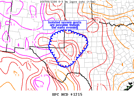
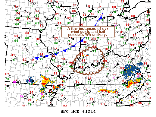
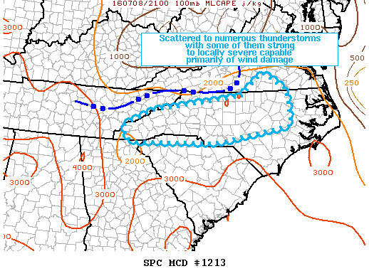
NOAA Storm Prediction Center Severe Thunderstorm Watch 363

Alomar Sharpe Friday, July 8, 2016 // 5:15 pm

WW 363 SEVERE TSTM NC VA 082215Z – 090400Z URGENT – IMMEDIATE BROADCAST REQUESTED SEVERE THUNDERSTORM WATCH NUMBER 363 NWS STORM PREDICTION CENTER NORMAN OK 615 PM EDT FRI JUL 8 2016 THE NWS STORM PREDICTION CENTER HAS ISSUED A * SEVERE THUNDERSTORM WATCH FOR PORTIONS OF MUCH OF NORTH CAROLINA SOUTH CENTRAL VIRGINIA * EFFECTIVE THIS FRIDAY NIGHT FROM… Read more →

Posted in Archive, Severe Weather Discussions | Tagged Severe Weather, Watches and Warnings, weather
NOAA Storm Prediction Center Mesoscale Discussion 1215

NOAA Storm Prediction Center Mesoscale Discussion 1215

Alomar Sharpe Friday, July 8, 2016 // 5:12 pm

MD 1215 CONCERNING SEVERE POTENTIAL…WATCH UNLIKELY FOR SERN NM / TX PERMIAN BASIN MESOSCALE DISCUSSION 1215 NWS STORM PREDICTION CENTER NORMAN OK 0511 PM CDT FRI JUL 08 2016 AREAS AFFECTED…SERN NM / TX PERMIAN BASIN CONCERNING…SEVERE POTENTIAL…WATCH UNLIKELY VALID 082211Z – 082345Z PROBABILITY OF WATCH ISSUANCE…20 PERCENT SUMMARY…ISOLATED TO SCATTERED DISORGANIZED THUNDERSTORMS WILL BE CAPABLE OF LOCALIZED GUSTS IN… Read more →

Posted in Archive, Severe Weather Discussions | Tagged Severe Weather, Watches and Warnings, weather
NOAA Storm Prediction Center Mesoscale Discussion 1214

NOAA Storm Prediction Center Mesoscale Discussion 1214

Alomar Sharpe Friday, July 8, 2016 // 5:07 pm

MD 1214 CONCERNING SEVERE POTENTIAL…WATCH UNLIKELY FOR SRN IND…WRN KY…FAR SERN IL MESOSCALE DISCUSSION 1214 NWS STORM PREDICTION CENTER NORMAN OK 0506 PM CDT FRI JUL 08 2016 AREAS AFFECTED…SRN IND…WRN KY…FAR SERN IL CONCERNING…SEVERE POTENTIAL…WATCH UNLIKELY VALID 082206Z – 082330Z PROBABILITY OF WATCH ISSUANCE…20 PERCENT SUMMARY…A VERY ISOLATED THREAT FOR LARGE HAIL AND DMGG WIND GUSTS MAY EXIST THIS… Read more →

Posted in Archive, Severe Weather Discussions | Tagged Severe Weather, Watches and Warnings, weather

NOAA Storm Prediction Center Severe Thunderstorm Watch 362

Alomar Sharpe Friday, July 8, 2016 // 4:55 pm

WW 362 SEVERE TSTM OK TX 082155Z – 090400Z URGENT – IMMEDIATE BROADCAST REQUESTED SEVERE THUNDERSTORM WATCH NUMBER 362 NWS STORM PREDICTION CENTER NORMAN OK 455 PM CDT FRI JUL 8 2016 THE NWS STORM PREDICTION CENTER HAS ISSUED A * SEVERE THUNDERSTORM WATCH FOR PORTIONS OF CENTRAL AND WESTERN OKLAHOMA WESTERN NORTH TEXAS * EFFECTIVE THIS FRIDAY AFTERNOON AND… Read more →

Posted in Archive, Severe Weather Discussions | Tagged Severe Weather, Watches and Warnings, weather
NOAA Storm Prediction Center Mesoscale Discussion 1213

NOAA Storm Prediction Center Mesoscale Discussion 1213

Alomar Sharpe Friday, July 8, 2016 // 4:49 pm

MD 1213 CONCERNING SEVERE POTENTIAL…SEVERE THUNDERSTORM WATCH LIKELY FOR S-CNTRL VA / MUCH OF WRN AND CNTRL NC / UPSTATE SC MESOSCALE DISCUSSION 1213 NWS STORM PREDICTION CENTER NORMAN OK 0448 PM CDT FRI JUL 08 2016 AREAS AFFECTED…S-CNTRL VA / MUCH OF WRN AND CNTRL NC / UPSTATE SC CONCERNING…SEVERE POTENTIAL…SEVERE THUNDERSTORM WATCH LIKELY VALID 082148Z – 082245Z PROBABILITY… Read more →

Posted in Archive, Severe Weather Discussions | Tagged Severe Weather, Watches and Warnings, weather
← Previous 1 … 266 267 268 … 2,028 Next →

Today’s Severe Weather Threat

SVR WX THREAT

Today’s Tornado Threat

SVR WX THREAT

Search The Site

Contributing Scientists

  • Alomar Sharpe
  • Amber Kulick
  • Branden Walker
  • Chris Vagasky
  • Colt Murray
  • Emily Riter
  • Kendall Junker
  • Matt Breland
  • Nick Lilja
  • NickelBlock Staff
  • Noah Gower

Wx Topics

2019 Atlantic Hurricane Season 2020 Atlantic hurricane Season Alabama Weather Amarillo weather Atlantic Hurricane Season Coronavirus COVID-19 COVID19 Earthquakes Flooding Geology Gulf Coast Weather hail hurricanes Louisiana Weather Mississippi Weather rain Severe Weather snow Texas Weather Thunderstorms Tornadoes Tropical Depressions Tropical Storms Tropical Weather tropics USGS Watches and Warnings weather Wind

What We Cover

  • Archive (10,136)
  • Climate (64)
  • Education (230)
  • Environment (8)
  • Forecasting (467)
  • Geology (210)
  • High Plains Weather (119)
  • Midwest Weather (35)
  • Northeast Weather (13)
  • Northwest Weather (5)
  • Not Weather (93)
  • Research (31)
  • River Flooding (23)
  • Severe Weather Discussions (8,640)
  • South Plains Weather (69)
  • Southeast Weather (312)
  • Space (19)
  • Storm Chasing (86)
  • Tropics (450)
  • Weather & Sports (4)
  • Weather & TV (37)
  • Weather History (8)
  • West Coast Weather (4)

Research

  • Conclusion: How multiple variables control TX/OK panhandle Spring severe weather
  • Findings: How multiple variables control TX/OK panhandle Spring severe weather
  • Methods: How multiple variables control TX/OK panhandle Spring severe weather
  • Introduction: How multiple variables control TX/OK panhandle Spring severe weather
  • Works Cited: How multiple variables control TX/OK panhandle Spring severe weather

Popular This Month

  • Remember that “Arctic Blast” people were posting about? Buckle up (6,957)
  • Another “Arctic Blast!” headed to the southeast says social media-rologists (2,420)
  • Arctic blast plunges Mississippi into ice age-like conditions colder than one of the moons of Jupiter (2,410)
  • More cold and snow has South Mississippi feeling like South Manitoba (1,888)
  • More wintry weather possible in South Mississippi next week (1,854)
  • Enough with the “Meteorologists get paid to be wrong” (1,617)
  • Afternoon Update: Snow possible for South Mississippi (960)
  • CIPS Analogs showing thunderstorms, possible severe weather, late next week for south Mississippi (949)
  • Freezing weather won’t kill all mosquitos (664)
  • Jan 16, south Mississippi morning snowfall update (541)
  • Instantly freeze water to make stalagmites (333)
  • Will it snow? A brief look at the steps to get it (318)

Primary Menu

  • About us
    • About us
    • How We Forecast
    • Archives
  • Our Services
    • Live Stream: Severe Weather Discussions
    • Go Storm Chasing
    • Pictures
  • Contact Us!
  • Jobs
  • Weather Safety
    • Weather Safety
    • Hurricane Preparedness Tips
    • Road Conditions
    • Current Conditions
    • South Mississippi river forecasts
    • Forecasting Presentation
  • Login

Secondary Menu

  • Severe Weather Outlook
    • Severe Outlook through Day 8
    • Severe Outlook By State
    • Today’s Severe Weather Threat
    • Today’s Tornado Threat
    • Today’s Severe Wind Threat
    • Today’s Severe Hail Threat
    • Excessive Rainfall Forecasts
  • Short Term Forecast
    • Current Radar & Satellite
    • Detailed National Forecast Discussion
    • National Surface Maps
    • National Temperatures
    • National Precipitation Chances
    • National Precipitation Estimates
    • National Snowfall Estimates
    • National Ice Estimates
    • National Convective Outlook
    • Public RAPTOR Map
    • Model Data Viewer
  • Tropics
  • 10 Day Trend
  • Seasonal Discussion

Copyright © 2026 NickelBlock Forecasting.

Powered by WordPress and Path. Back to Top

Google+
  • About us
  • Our Services
  • Contact Us!
  • Jobs
  • Weather Safety
  • Login