Primary Menu Search
  • About us
    • About us
    • How We Forecast
    • Archives
  • Our Services
    • Live Stream: Severe Weather Discussions
    • Go Storm Chasing
    • Pictures
  • Contact Us!
  • Jobs
  • Weather Safety
    • Weather Safety
    • Hurricane Preparedness Tips
    • Road Conditions
    • Current Conditions
    • South Mississippi river forecasts
    • Forecasting Presentation
  • Login

NickelBlock Forecasting

Funny name. Serious data.

Secondary Menu
  • Severe Weather Outlook
    • Severe Outlook through Day 8
    • Severe Outlook By State
    • Today’s Severe Weather Threat
    • Today’s Tornado Threat
    • Today’s Severe Wind Threat
    • Today’s Severe Hail Threat
    • Excessive Rainfall Forecasts
  • Short Term Forecast
    • Current Radar & Satellite
    • Detailed National Forecast Discussion
    • National Surface Maps
    • National Temperatures
    • National Precipitation Chances
    • National Precipitation Estimates
    • National Snowfall Estimates
    • National Ice Estimates
    • National Convective Outlook
    • Public RAPTOR Map
    • Model Data Viewer
  • Tropics
  • 10 Day Trend
  • Seasonal Discussion
You are here: Home ∼ Page 66
9/17/19 - Tropics get active: Humberto, Imelda and TD10

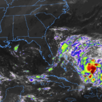
9/17/19 – Tropics get active: Humberto, Imelda and TD10

Nick Lilja Tuesday, September 17, 2019 // 12:15 pm

And just like that, things have picked back up again in the Atlantic. There is a Category 2 Hurricane, Humberto. A newly-minted Tropical storm, Imelda and a Tropical Depression east of the Leeward Islands. From the NHC Hurricane Humberto SUMMARY OF 200 PM EDT…1800 UTC…INFORMATION ———————————————- LOCATION…30.8N 72.9W ABOUT 490 MI…785 KM WSW OF BERMUDA MAXIMUM SUSTAINED WINDS…100 MPH…155 KM/H… Read more →

Posted in Archive, Forecasting, Tropics | Tagged 2019 Atlantic Hurricane Season, Humberto, Hurricane Humberto, Imelda, TD 10, TD10, Tropical Storm Imelda, Tropical Weather, tropics, weather

PM Tropical Update – Latest on Invest95L / PTC9 / Humberto

Nick Lilja Thursday, September 12, 2019 // 4:32 pm

SUMMARY OF 500 PM EDT…2100 UTC…INFORMATION ———————————————- LOCATION…23.7N 74.8W ABOUT 235 MI…380 KM SE OF GREAT ABACO ISLAND ABOUT 310 MI…500 KM SE OF FREEPORT GRAND BAHAMA ISLAND MAXIMUM SUSTAINED WINDS…30 MPH…45 KM/H PRESENT MOVEMENT…NW OR 305 DEGREES AT 8 MPH…13 KM/H MINIMUM CENTRAL PRESSURE…1008 MB…29.77 INCHES DISCUSSION Potential Tropical Cyclone Nine Discussion Number 1 NWS National Hurricane Center Miami… Read more →

Posted in Archive, Forecasting, Tropics | Tagged 2019 Atlantic Hurricane Season, Humberto, Invest95L, PTC9, Tropical Weather, tropics, weather
9/12/19 Tropical Update - Overnight model track shift on Invest95L

9/12/19 Tropical Update – Overnight model track shift on Invest95L

Nick Lilja Thursday, September 12, 2019 // 7:36 am

The model guidance for Invest 95L made a distinct shift overnight to the east. The above image may look like a bit of chicken-scratch, but what it shows is a push to the east in the genesis of a tropical system by the ECMWF computer weather model. And it isn’t just one model that did this. You can also see… Read more →

Posted in Archive, Forecasting, Tropics | Tagged 2019 Atlantic Hurricane Season, Humberto, Invest95L, Tropcial Depression, tropical storm humberto, Tropical Weather, tropics, weather
Alex Herbst is gone, far too soon

Alex Herbst is gone, far too soon

Nick Lilja Wednesday, September 11, 2019 // 11:39 pm | 1 Response

Loss is the most difficult hurdle to overcome. Voids can’t be repaired. A void is just there. Replacement isn’t an option. There is just a hole. Where someone once was. Admittedly, I don’t deal with loss well. So, this new hole stings. Tonight, the world lost Alex Herbst. At 26. Twenty. Six. He was a great young meteorologist just barely… Read more →

Posted in Archive, Weather & TV | Tagged Alex herbst, Mississippi State, Television meteorology

9/11/19 Tropical Update – Invest95L & Invest94L

Nick Lilja Wednesday, September 11, 2019 // 3:12 pm

From the NHC Tropical Weather Outlook NWS National Hurricane Center Miami FL Issued by the NWS Weather Prediction Center College Park MD 200 PM EDT Wed Sep 11 2019 For the North Atlantic…Caribbean Sea and the Gulf of Mexico: 1. A large area of showers and thunderstorms was located along a sharp surface trough from near eastern Cuba through the… Read more →

Posted in Archive, Forecasting, Tropics | Tagged 2019 Atlantic Hurricane Season, Invest 94L, Invest95L
← Previous 1 … 65 66 67 … 2,028 Next →

Today’s Severe Weather Threat

SVR WX THREAT

Today’s Tornado Threat

SVR WX THREAT

Search The Site

Contributing Scientists

  • Alomar Sharpe
  • Amber Kulick
  • Branden Walker
  • Chris Vagasky
  • Colt Murray
  • Emily Riter
  • Kendall Junker
  • Matt Breland
  • Nick Lilja
  • NickelBlock Staff
  • Noah Gower

Wx Topics

2019 Atlantic Hurricane Season 2020 Atlantic hurricane Season Alabama Weather Amarillo weather Atlantic Hurricane Season Coronavirus COVID-19 COVID19 Earthquakes Flooding Geology Gulf Coast Weather hail hurricanes Louisiana Weather Mississippi Weather rain Severe Weather snow Texas Weather Thunderstorms Tornadoes Tropical Depressions Tropical Storms Tropical Weather tropics USGS Watches and Warnings weather Wind

What We Cover

  • Archive (10,136)
  • Climate (64)
  • Education (230)
  • Environment (8)
  • Forecasting (467)
  • Geology (210)
  • High Plains Weather (119)
  • Midwest Weather (35)
  • Northeast Weather (13)
  • Northwest Weather (5)
  • Not Weather (93)
  • Research (31)
  • River Flooding (23)
  • Severe Weather Discussions (8,640)
  • South Plains Weather (69)
  • Southeast Weather (312)
  • Space (19)
  • Storm Chasing (86)
  • Tropics (450)
  • Weather & Sports (4)
  • Weather & TV (37)
  • Weather History (8)
  • West Coast Weather (4)

Research

  • Conclusion: How multiple variables control TX/OK panhandle Spring severe weather
  • Findings: How multiple variables control TX/OK panhandle Spring severe weather
  • Methods: How multiple variables control TX/OK panhandle Spring severe weather
  • Introduction: How multiple variables control TX/OK panhandle Spring severe weather
  • Works Cited: How multiple variables control TX/OK panhandle Spring severe weather

Popular This Month

  • Remember that “Arctic Blast” people were posting about? Buckle up (6,957)
  • Another “Arctic Blast!” headed to the southeast says social media-rologists (2,420)
  • Arctic blast plunges Mississippi into ice age-like conditions colder than one of the moons of Jupiter (2,410)
  • More cold and snow has South Mississippi feeling like South Manitoba (1,888)
  • More wintry weather possible in South Mississippi next week (1,854)
  • Enough with the “Meteorologists get paid to be wrong” (1,617)
  • Afternoon Update: Snow possible for South Mississippi (960)
  • CIPS Analogs showing thunderstorms, possible severe weather, late next week for south Mississippi (949)
  • Freezing weather won’t kill all mosquitos (664)
  • Jan 16, south Mississippi morning snowfall update (541)
  • Instantly freeze water to make stalagmites (333)
  • Will it snow? A brief look at the steps to get it (318)

Primary Menu

  • About us
    • About us
    • How We Forecast
    • Archives
  • Our Services
    • Live Stream: Severe Weather Discussions
    • Go Storm Chasing
    • Pictures
  • Contact Us!
  • Jobs
  • Weather Safety
    • Weather Safety
    • Hurricane Preparedness Tips
    • Road Conditions
    • Current Conditions
    • South Mississippi river forecasts
    • Forecasting Presentation
  • Login

Secondary Menu

  • Severe Weather Outlook
    • Severe Outlook through Day 8
    • Severe Outlook By State
    • Today’s Severe Weather Threat
    • Today’s Tornado Threat
    • Today’s Severe Wind Threat
    • Today’s Severe Hail Threat
    • Excessive Rainfall Forecasts
  • Short Term Forecast
    • Current Radar & Satellite
    • Detailed National Forecast Discussion
    • National Surface Maps
    • National Temperatures
    • National Precipitation Chances
    • National Precipitation Estimates
    • National Snowfall Estimates
    • National Ice Estimates
    • National Convective Outlook
    • Public RAPTOR Map
    • Model Data Viewer
  • Tropics
  • 10 Day Trend
  • Seasonal Discussion

Copyright © 2026 NickelBlock Forecasting.

Powered by WordPress and Path. Back to Top

Google+
  • About us
  • Our Services
  • Contact Us!
  • Jobs
  • Weather Safety
  • Login