Primary Menu Search
  • About us
    • About us
    • How We Forecast
    • Archives
  • Our Services
    • Live Stream: Severe Weather Discussions
    • Go Storm Chasing
    • Pictures
  • Contact Us!
  • Jobs
  • Weather Safety
    • Weather Safety
    • Hurricane Preparedness Tips
    • Road Conditions
    • Current Conditions
    • South Mississippi river forecasts
    • Forecasting Presentation
  • Login

NickelBlock Forecasting

Funny name. Serious data.

Secondary Menu
  • Severe Weather Outlook
    • Severe Outlook through Day 8
    • Severe Outlook By State
    • Today’s Severe Weather Threat
    • Today’s Tornado Threat
    • Today’s Severe Wind Threat
    • Today’s Severe Hail Threat
    • Excessive Rainfall Forecasts
  • Short Term Forecast
    • Current Radar & Satellite
    • Detailed National Forecast Discussion
    • National Surface Maps
    • National Temperatures
    • National Precipitation Chances
    • National Precipitation Estimates
    • National Snowfall Estimates
    • National Ice Estimates
    • National Convective Outlook
    • Public RAPTOR Map
    • Model Data Viewer
  • Tropics
  • 10 Day Trend
  • Seasonal Discussion
You are here: Home ∼ Page 494
NOAA Storm Prediction Center Mesoscale Discussion 674

NOAA Storm Prediction Center Mesoscale Discussion 674

Alomar Sharpe Saturday, May 21, 2016 // 9:30 pm

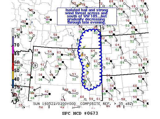
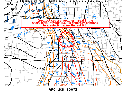
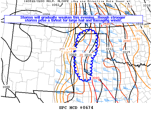
MD 0674 CONCERNING SEVERE THUNDERSTORM WATCH 186… FOR NORTHWEST TX INCLUDING PART OF THE TX PANHANDLE…AND INTO THE OK PANHANDLE MESOSCALE DISCUSSION 0674 NWS STORM PREDICTION CENTER NORMAN OK 0929 PM CDT SAT MAY 21 2016 AREAS AFFECTED…NORTHWEST TX INCLUDING PART OF THE TX PANHANDLE…AND INTO THE OK PANHANDLE CONCERNING…SEVERE THUNDERSTORM WATCH 186… VALID 220229Z – 220330Z THE SEVERE WEATHER… Read more →

Posted in Archive, Severe Weather Discussions | Tagged Severe Weather, Watches and Warnings, weather
NOAA Storm Prediction Center Mesoscale Discussion 673

NOAA Storm Prediction Center Mesoscale Discussion 673

Alomar Sharpe Saturday, May 21, 2016 // 9:17 pm

MD 0673 CONCERNING SEVERE THUNDERSTORM WATCH 189… FOR ERN WY…SERN MT MESOSCALE DISCUSSION 0673 NWS STORM PREDICTION CENTER NORMAN OK 0916 PM CDT SAT MAY 21 2016 AREAS AFFECTED…ERN WY…SERN MT CONCERNING…SEVERE THUNDERSTORM WATCH 189… VALID 220216Z – 220345Z THE SEVERE WEATHER THREAT FOR SEVERE THUNDERSTORM WATCH 189 CONTINUES. SUMMARY…ISOLATED HAIL THREAT AND STRONG WIND THREAT SHOULD GRADUALLY DECREASE THROUGH… Read more →

Posted in Archive, Severe Weather Discussions | Tagged Severe Weather, Watches and Warnings, weather
NOAA Storm Prediction Center Mesoscale Discussion 672

NOAA Storm Prediction Center Mesoscale Discussion 672

Alomar Sharpe Saturday, May 21, 2016 // 9:03 pm

MD 0672 CONCERNING TORNADO WATCH 187… FOR WEST AND NORTHWEST KS MESOSCALE DISCUSSION 0672 NWS STORM PREDICTION CENTER NORMAN OK 0902 PM CDT SAT MAY 21 2016 AREAS AFFECTED…WEST AND NORTHWEST KS CONCERNING…TORNADO WATCH 187… VALID 220202Z – 220300Z THE SEVERE WEATHER THREAT FOR TORNADO WATCH 187 CONTINUES. SUMMARY…THE GREATEST SEVERE-WEATHER THREAT IN THE SHORT TERM /THROUGH 03Z/ IS GENERALLY… Read more →

Posted in Archive, Severe Weather Discussions | Tagged Severe Weather, Watches and Warnings, weather
Storm Prediction Center May 22, 2016 UTC Evening Outlook

Storm Prediction Center May 22, 2016 UTC Evening Outlook

Alomar Sharpe Saturday, May 21, 2016 // 8:38 pm

SPC 0100Z Day 1 Outlook DAY 1 CONVECTIVE OUTLOOK NWS STORM PREDICTION CENTER NORMAN OK 0800 PM CDT SAT MAY 21 2016 VALID 220100Z – 221200Z …THERE IS A SLGT RISK OF SEVERE THUNDERSTORMS OVER A PORTION OF THE NRN HIGH PLAINS… …THERE IS A SLGT RISK OF SEVERE THUNDERSTORMS OVER A PORTION OF THE SRN AND CNTRL HIGH PLAINS…… Read more →

Posted in Archive, Severe Weather Discussions | Tagged Severe Weather, weather
← Previous 1 … 493 494 495 … 2,028 Next →

Today’s Severe Weather Threat

SVR WX THREAT

Today’s Tornado Threat

SVR WX THREAT

Search The Site

Contributing Scientists

  • Alomar Sharpe
  • Amber Kulick
  • Branden Walker
  • Chris Vagasky
  • Colt Murray
  • Emily Riter
  • Kendall Junker
  • Matt Breland
  • Nick Lilja
  • NickelBlock Staff
  • Noah Gower

Wx Topics

2019 Atlantic Hurricane Season 2020 Atlantic hurricane Season Alabama Weather Amarillo weather Atlantic Hurricane Season Coronavirus COVID-19 COVID19 Earthquakes Flooding Geology Gulf Coast Weather hail hurricanes Louisiana Weather Mississippi Weather rain Severe Weather snow Texas Weather Thunderstorms Tornadoes Tropical Depressions Tropical Storms Tropical Weather tropics USGS Watches and Warnings weather Wind

What We Cover

  • Archive (10,136)
  • Climate (64)
  • Education (230)
  • Environment (8)
  • Forecasting (467)
  • Geology (210)
  • High Plains Weather (119)
  • Midwest Weather (35)
  • Northeast Weather (13)
  • Northwest Weather (5)
  • Not Weather (93)
  • Research (31)
  • River Flooding (23)
  • Severe Weather Discussions (8,640)
  • South Plains Weather (69)
  • Southeast Weather (312)
  • Space (19)
  • Storm Chasing (86)
  • Tropics (450)
  • Weather & Sports (4)
  • Weather & TV (37)
  • Weather History (8)
  • West Coast Weather (4)

Research

  • Conclusion: How multiple variables control TX/OK panhandle Spring severe weather
  • Findings: How multiple variables control TX/OK panhandle Spring severe weather
  • Methods: How multiple variables control TX/OK panhandle Spring severe weather
  • Introduction: How multiple variables control TX/OK panhandle Spring severe weather
  • Works Cited: How multiple variables control TX/OK panhandle Spring severe weather

Popular This Month

  • Remember that “Arctic Blast” people were posting about? Buckle up (6,957)
  • Another “Arctic Blast!” headed to the southeast says social media-rologists (2,420)
  • Arctic blast plunges Mississippi into ice age-like conditions colder than one of the moons of Jupiter (2,410)
  • More cold and snow has South Mississippi feeling like South Manitoba (1,888)
  • More wintry weather possible in South Mississippi next week (1,854)
  • Enough with the “Meteorologists get paid to be wrong” (1,617)
  • Afternoon Update: Snow possible for South Mississippi (960)
  • CIPS Analogs showing thunderstorms, possible severe weather, late next week for south Mississippi (949)
  • Freezing weather won’t kill all mosquitos (664)
  • Jan 16, south Mississippi morning snowfall update (541)
  • Instantly freeze water to make stalagmites (333)
  • Will it snow? A brief look at the steps to get it (318)

Primary Menu

  • About us
    • About us
    • How We Forecast
    • Archives
  • Our Services
    • Live Stream: Severe Weather Discussions
    • Go Storm Chasing
    • Pictures
  • Contact Us!
  • Jobs
  • Weather Safety
    • Weather Safety
    • Hurricane Preparedness Tips
    • Road Conditions
    • Current Conditions
    • South Mississippi river forecasts
    • Forecasting Presentation
  • Login

Secondary Menu

  • Severe Weather Outlook
    • Severe Outlook through Day 8
    • Severe Outlook By State
    • Today’s Severe Weather Threat
    • Today’s Tornado Threat
    • Today’s Severe Wind Threat
    • Today’s Severe Hail Threat
    • Excessive Rainfall Forecasts
  • Short Term Forecast
    • Current Radar & Satellite
    • Detailed National Forecast Discussion
    • National Surface Maps
    • National Temperatures
    • National Precipitation Chances
    • National Precipitation Estimates
    • National Snowfall Estimates
    • National Ice Estimates
    • National Convective Outlook
    • Public RAPTOR Map
    • Model Data Viewer
  • Tropics
  • 10 Day Trend
  • Seasonal Discussion

Copyright © 2026 NickelBlock Forecasting.

Powered by WordPress and Path. Back to Top

Google+
  • About us
  • Our Services
  • Contact Us!
  • Jobs
  • Weather Safety
  • Login