Primary Menu Search
  • About us
    • About us
    • How We Forecast
    • Archives
  • Our Services
    • Live Stream: Severe Weather Discussions
    • Go Storm Chasing
    • Pictures
  • Contact Us!
  • Jobs
  • Weather Safety
    • Weather Safety
    • Hurricane Preparedness Tips
    • Road Conditions
    • Current Conditions
    • South Mississippi river forecasts
    • Forecasting Presentation
  • Login

NickelBlock Forecasting

Funny name. Serious data.

Secondary Menu
  • Severe Weather Outlook
    • Severe Outlook through Day 8
    • Severe Outlook By State
    • Today’s Severe Weather Threat
    • Today’s Tornado Threat
    • Today’s Severe Wind Threat
    • Today’s Severe Hail Threat
    • Excessive Rainfall Forecasts
  • Short Term Forecast
    • Current Radar & Satellite
    • Detailed National Forecast Discussion
    • National Surface Maps
    • National Temperatures
    • National Precipitation Chances
    • National Precipitation Estimates
    • National Snowfall Estimates
    • National Ice Estimates
    • National Convective Outlook
    • Public RAPTOR Map
    • Model Data Viewer
  • Tropics
  • 10 Day Trend
  • Seasonal Discussion
You are here: Home ∼ Page 449

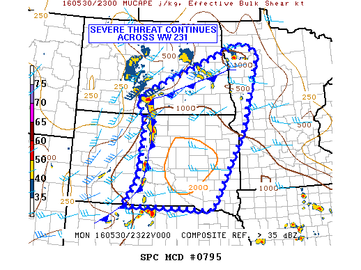
NOAA Storm Prediction Center Severe Thunderstorm Watch 233

Alomar Sharpe Monday, May 30, 2016 // 7:00 pm

WW 233 SEVERE TSTM TX 302355Z – 310500Z URGENT – IMMEDIATE BROADCAST REQUESTED SEVERE THUNDERSTORM WATCH NUMBER 233 NWS STORM PREDICTION CENTER NORMAN OK 655 PM CDT MON MAY 30 2016 THE NWS STORM PREDICTION CENTER HAS ISSUED A * SEVERE THUNDERSTORM WATCH FOR PORTIONS OF WEST-CENTRAL TEXAS * EFFECTIVE THIS MONDAY NIGHT FROM 655 PM UNTIL MIDNIGHT CDT. *… Read more →

Posted in Archive, Severe Weather Discussions | Tagged Severe Weather, Watches and Warnings, weather
NOAA Storm Prediction Center Mesoscale Discussion 795

NOAA Storm Prediction Center Mesoscale Discussion 795

Alomar Sharpe Monday, May 30, 2016 // 6:38 pm

MD 0795 CONCERNING SEVERE THUNDERSTORM WATCH 231… FOR THE ERN DAKOTAS INTO NWRN MN MESOSCALE DISCUSSION 0795 NWS STORM PREDICTION CENTER NORMAN OK 0637 PM CDT MON MAY 30 2016 AREAS AFFECTED…THE ERN DAKOTAS INTO NWRN MN CONCERNING…SEVERE THUNDERSTORM WATCH 231… VALID 302337Z – 310130Z THE SEVERE WEATHER THREAT FOR SEVERE THUNDERSTORM WATCH 231 CONTINUES. SUMMARY…SEVERE HAIL AND WIND REMAIN… Read more →

Posted in Archive, Severe Weather Discussions | Tagged Severe Weather, Watches and Warnings, weather
NOAA Storm Prediction Center Mesoscale Discussion 794

NOAA Storm Prediction Center Mesoscale Discussion 794

Alomar Sharpe Monday, May 30, 2016 // 5:50 pm

MD 0794 CONCERNING SEVERE POTENTIAL…WATCH POSSIBLE FOR PARTS OF W CNTRL TX MESOSCALE DISCUSSION 0794 NWS STORM PREDICTION CENTER NORMAN OK 0549 PM CDT MON MAY 30 2016 AREAS AFFECTED…PARTS OF W CNTRL TX CONCERNING…SEVERE POTENTIAL…WATCH POSSIBLE VALID 302249Z – 310115Z PROBABILITY OF WATCH ISSUANCE…40 PERCENT SUMMARY…ISOLATED SEVERE STORMS CAPABLE OF MAINLY HAIL ARE POSSIBLE THIS EVENING ACROSS PARTS OF… Read more →

Posted in Archive, Severe Weather Discussions | Tagged Severe Weather, Watches and Warnings, weather
NOAA Storm Prediction Center Mesoscale Discussion 793

NOAA Storm Prediction Center Mesoscale Discussion 793

Alomar Sharpe Monday, May 30, 2016 // 5:15 pm

MD 0793 CONCERNING SEVERE POTENTIAL…WATCH UNLIKELY FOR PORTIONS OF ERN NEB…WRN/CNTRL IA…SRN MN…NWRN MO MESOSCALE DISCUSSION 0793 NWS STORM PREDICTION CENTER NORMAN OK 0514 PM CDT MON MAY 30 2016 AREAS AFFECTED…PORTIONS OF ERN NEB…WRN/CNTRL IA…SRN MN…NWRN MO CONCERNING…SEVERE POTENTIAL…WATCH UNLIKELY VALID 302214Z – 302345Z PROBABILITY OF WATCH ISSUANCE…20 PERCENT SUMMARY…THUNDERSTORMS CAPABLE OF LOCALLY SEVERE HAIL AND PERHAPS ISOLATED DOWNBURST… Read more →

Posted in Archive, Severe Weather Discussions | Tagged Severe Weather, Watches and Warnings, weather
Storm Prediction Center May 30, 2016 Afternoon Outlook

Storm Prediction Center May 30, 2016 Afternoon Outlook

Alomar Sharpe Monday, May 30, 2016 // 4:38 pm

SPC 2000Z Day 1 Outlook DAY 1 CONVECTIVE OUTLOOK NWS STORM PREDICTION CENTER NORMAN OK 0301 PM CDT MON MAY 30 2016 VALID 302000Z – 311200Z …THERE IS A SLGT RISK OF SEVERE THUNDERSTORMS ACROSS PARTS OF THE CNTRL AND NRN PLAINS… …THERE IS A SLGT RISK OF SEVERE THUNDERSTORMS ACROSS PARTS OF WEST TX… …THERE IS A MRGL RISK… Read more →

Posted in Archive, Severe Weather Discussions | Tagged Severe Weather, weather
← Previous 1 … 448 449 450 … 2,028 Next →

Today’s Severe Weather Threat

SVR WX THREAT

Today’s Tornado Threat

SVR WX THREAT

Search The Site

Contributing Scientists

  • Alomar Sharpe
  • Amber Kulick
  • Branden Walker
  • Chris Vagasky
  • Colt Murray
  • Emily Riter
  • Kendall Junker
  • Matt Breland
  • Nick Lilja
  • NickelBlock Staff
  • Noah Gower

Wx Topics

2019 Atlantic Hurricane Season 2020 Atlantic hurricane Season Alabama Weather Amarillo weather Atlantic Hurricane Season Coronavirus COVID-19 COVID19 Earthquakes Flooding Geology Gulf Coast Weather hail hurricanes Louisiana Weather Mississippi Weather rain Severe Weather snow Texas Weather Thunderstorms Tornadoes Tropical Depressions Tropical Storms Tropical Weather tropics USGS Watches and Warnings weather Wind

What We Cover

  • Archive (10,136)
  • Climate (64)
  • Education (230)
  • Environment (8)
  • Forecasting (467)
  • Geology (210)
  • High Plains Weather (119)
  • Midwest Weather (35)
  • Northeast Weather (13)
  • Northwest Weather (5)
  • Not Weather (93)
  • Research (31)
  • River Flooding (23)
  • Severe Weather Discussions (8,640)
  • South Plains Weather (69)
  • Southeast Weather (312)
  • Space (19)
  • Storm Chasing (86)
  • Tropics (450)
  • Weather & Sports (4)
  • Weather & TV (37)
  • Weather History (8)
  • West Coast Weather (4)

Research

  • Conclusion: How multiple variables control TX/OK panhandle Spring severe weather
  • Findings: How multiple variables control TX/OK panhandle Spring severe weather
  • Methods: How multiple variables control TX/OK panhandle Spring severe weather
  • Introduction: How multiple variables control TX/OK panhandle Spring severe weather
  • Works Cited: How multiple variables control TX/OK panhandle Spring severe weather

Popular This Month

  • Remember that “Arctic Blast” people were posting about? Buckle up (6,957)
  • Another “Arctic Blast!” headed to the southeast says social media-rologists (2,420)
  • Arctic blast plunges Mississippi into ice age-like conditions colder than one of the moons of Jupiter (2,410)
  • More cold and snow has South Mississippi feeling like South Manitoba (1,888)
  • More wintry weather possible in South Mississippi next week (1,854)
  • Enough with the “Meteorologists get paid to be wrong” (1,617)
  • Afternoon Update: Snow possible for South Mississippi (960)
  • CIPS Analogs showing thunderstorms, possible severe weather, late next week for south Mississippi (949)
  • Freezing weather won’t kill all mosquitos (664)
  • Jan 16, south Mississippi morning snowfall update (541)
  • Instantly freeze water to make stalagmites (333)
  • Will it snow? A brief look at the steps to get it (318)

Primary Menu

  • About us
    • About us
    • How We Forecast
    • Archives
  • Our Services
    • Live Stream: Severe Weather Discussions
    • Go Storm Chasing
    • Pictures
  • Contact Us!
  • Jobs
  • Weather Safety
    • Weather Safety
    • Hurricane Preparedness Tips
    • Road Conditions
    • Current Conditions
    • South Mississippi river forecasts
    • Forecasting Presentation
  • Login

Secondary Menu

  • Severe Weather Outlook
    • Severe Outlook through Day 8
    • Severe Outlook By State
    • Today’s Severe Weather Threat
    • Today’s Tornado Threat
    • Today’s Severe Wind Threat
    • Today’s Severe Hail Threat
    • Excessive Rainfall Forecasts
  • Short Term Forecast
    • Current Radar & Satellite
    • Detailed National Forecast Discussion
    • National Surface Maps
    • National Temperatures
    • National Precipitation Chances
    • National Precipitation Estimates
    • National Snowfall Estimates
    • National Ice Estimates
    • National Convective Outlook
    • Public RAPTOR Map
    • Model Data Viewer
  • Tropics
  • 10 Day Trend
  • Seasonal Discussion

Copyright © 2026 NickelBlock Forecasting.

Powered by WordPress and Path. Back to Top

Google+
  • About us
  • Our Services
  • Contact Us!
  • Jobs
  • Weather Safety
  • Login