Primary Menu Search
  • About us
    • About us
    • How We Forecast
    • Archives
  • Our Services
    • Live Stream: Severe Weather Discussions
    • Go Storm Chasing
    • Pictures
  • Contact Us!
  • Jobs
  • Weather Safety
    • Weather Safety
    • Hurricane Preparedness Tips
    • Road Conditions
    • Current Conditions
    • South Mississippi river forecasts
    • Forecasting Presentation
  • Login

NickelBlock Forecasting

Funny name. Serious data.

Secondary Menu
  • Severe Weather Outlook
    • Severe Outlook through Day 8
    • Severe Outlook By State
    • Today’s Severe Weather Threat
    • Today’s Tornado Threat
    • Today’s Severe Wind Threat
    • Today’s Severe Hail Threat
    • Excessive Rainfall Forecasts
  • Short Term Forecast
    • Current Radar & Satellite
    • Detailed National Forecast Discussion
    • National Surface Maps
    • National Temperatures
    • National Precipitation Chances
    • National Precipitation Estimates
    • National Snowfall Estimates
    • National Ice Estimates
    • National Convective Outlook
    • Public RAPTOR Map
    • Model Data Viewer
  • Tropics
  • 10 Day Trend
  • Seasonal Discussion
You are here: Home ∼ Page 427
NOAA Storm Prediction Center Mesoscale Discussion 854

NOAA Storm Prediction Center Mesoscale Discussion 854

Alomar Sharpe Thursday, June 9, 2016 // 6:31 pm

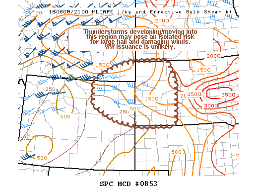
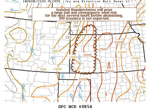
MD 0854 CONCERNING SEVERE POTENTIAL…WATCH UNLIKELY FOR PORTIONS OF WRN KS AND SWRN NEB MESOSCALE DISCUSSION 0854 NWS STORM PREDICTION CENTER NORMAN OK 0630 PM CDT THU JUN 09 2016 AREAS AFFECTED…PORTIONS OF WRN KS AND SWRN NEB CONCERNING…SEVERE POTENTIAL…WATCH UNLIKELY VALID 092330Z – 100100Z PROBABILITY OF WATCH ISSUANCE…5 PERCENT SUMMARY…ISOLATED THUNDERSTORMS THAT HAVE FORMED ACROSS THIS REGION WILL POSE… Read more →

Posted in Archive, Severe Weather Discussions | Tagged Severe Weather, Watches and Warnings, weather
NOAA Storm Prediction Center Mesoscale Discussion 853

NOAA Storm Prediction Center Mesoscale Discussion 853

Alomar Sharpe Thursday, June 9, 2016 // 5:07 pm

MD 0853 CONCERNING SEVERE POTENTIAL…WATCH UNLIKELY FOR PORTIONS OF SERN MT…NERN WY…AND WRN SD MESOSCALE DISCUSSION 0853 NWS STORM PREDICTION CENTER NORMAN OK 0506 PM CDT THU JUN 09 2016 AREAS AFFECTED…PORTIONS OF SERN MT…NERN WY…AND WRN SD CONCERNING…SEVERE POTENTIAL…WATCH UNLIKELY VALID 092206Z – 092330Z PROBABILITY OF WATCH ISSUANCE…20 PERCENT SUMMARY…THUNDERSTORMS DEVELOPING/MOVING ACROSS THIS REGION MAY POSE AN ISOLATED SEVERE… Read more →

Posted in Archive, Severe Weather Discussions | Tagged Severe Weather, Watches and Warnings, weather
Storm Prediction Center Jun 9, 2016 Afternoon Outlook

Storm Prediction Center Jun 9, 2016 Afternoon Outlook

Alomar Sharpe Thursday, June 9, 2016 // 4:38 pm

SPC 2000Z Day 1 Outlook DAY 1 CONVECTIVE OUTLOOK NWS STORM PREDICTION CENTER NORMAN OK 0300 PM CDT THU JUN 09 2016 VALID 092000Z – 101200Z …THERE IS AN ENH RISK OF SEVERE THUNDERSTORMS FOR PORTIONS OF CNTRL AND NERN MT… …THERE IS A SLGT RISK OF SEVERE THUNDERSTORMS OVER W-CNTRL MT THROUGH WRN ND… …THERE IS A MRGL RISK… Read more →

Posted in Archive, Severe Weather Discussions | Tagged Severe Weather, weather
NOAA Storm Prediction Center Mesoscale Discussion 852

NOAA Storm Prediction Center Mesoscale Discussion 852

Alomar Sharpe Thursday, June 9, 2016 // 3:52 pm

MD 0852 CONCERNING SEVERE THUNDERSTORM WATCH 239… FOR PORTIONS OF CNTRL/ERN MT MESOSCALE DISCUSSION 0852 NWS STORM PREDICTION CENTER NORMAN OK 0351 PM CDT THU JUN 09 2016 AREAS AFFECTED…PORTIONS OF CNTRL/ERN MT CONCERNING…SEVERE THUNDERSTORM WATCH 239… VALID 092051Z – 092215Z THE SEVERE WEATHER THREAT FOR SEVERE THUNDERSTORM WATCH 239 CONTINUES. SUMMARY…SCATTERED SUPERCELLS WILL CONTINUE MOVING ACROSS PORTIONS OF CNTRL/ERN… Read more →

Posted in Archive, Severe Weather Discussions | Tagged Severe Weather, Watches and Warnings, weather
NOAA Storm Prediction Center Mesoscale Discussion 850

NOAA Storm Prediction Center Mesoscale Discussion 850

Alomar Sharpe Thursday, June 9, 2016 // 3:32 pm

MD 0850 CONCERNING SEVERE POTENTIAL…WATCH UNLIKELY FOR ERN NM…TX PANHANDLE…WEST TX MESOSCALE DISCUSSION 0850 NWS STORM PREDICTION CENTER NORMAN OK 0331 PM CDT THU JUN 09 2016 AREAS AFFECTED…ERN NM…TX PANHANDLE…WEST TX CONCERNING…SEVERE POTENTIAL…WATCH UNLIKELY VALID 092031Z – 092300Z PROBABILITY OF WATCH ISSUANCE…20 PERCENT SUMMARY…A THREAT FOR STRONG WIND GUSTS AND HAIL WILL BE POSSIBLE LATE THIS AFTERNOON INTO EARLY… Read more →

Posted in Archive, Severe Weather Discussions | Tagged Severe Weather, Watches and Warnings, weather
← Previous 1 … 426 427 428 … 2,028 Next →

Today’s Severe Weather Threat

SVR WX THREAT

Today’s Tornado Threat

SVR WX THREAT

Search The Site

Contributing Scientists

  • Alomar Sharpe
  • Amber Kulick
  • Branden Walker
  • Chris Vagasky
  • Colt Murray
  • Emily Riter
  • Kendall Junker
  • Matt Breland
  • Nick Lilja
  • NickelBlock Staff
  • Noah Gower

Wx Topics

2019 Atlantic Hurricane Season 2020 Atlantic hurricane Season Alabama Weather Amarillo weather Atlantic Hurricane Season Coronavirus COVID-19 COVID19 Earthquakes Flooding Geology Gulf Coast Weather hail hurricanes Louisiana Weather Mississippi Weather rain Severe Weather snow Texas Weather Thunderstorms Tornadoes Tropical Depressions Tropical Storms Tropical Weather tropics USGS Watches and Warnings weather Wind

What We Cover

  • Archive (10,136)
  • Climate (64)
  • Education (230)
  • Environment (8)
  • Forecasting (467)
  • Geology (210)
  • High Plains Weather (119)
  • Midwest Weather (35)
  • Northeast Weather (13)
  • Northwest Weather (5)
  • Not Weather (93)
  • Research (31)
  • River Flooding (23)
  • Severe Weather Discussions (8,640)
  • South Plains Weather (69)
  • Southeast Weather (312)
  • Space (19)
  • Storm Chasing (86)
  • Tropics (450)
  • Weather & Sports (4)
  • Weather & TV (37)
  • Weather History (8)
  • West Coast Weather (4)

Research

  • Conclusion: How multiple variables control TX/OK panhandle Spring severe weather
  • Findings: How multiple variables control TX/OK panhandle Spring severe weather
  • Methods: How multiple variables control TX/OK panhandle Spring severe weather
  • Introduction: How multiple variables control TX/OK panhandle Spring severe weather
  • Works Cited: How multiple variables control TX/OK panhandle Spring severe weather

Popular This Month

  • Remember that “Arctic Blast” people were posting about? Buckle up (6,957)
  • Another “Arctic Blast!” headed to the southeast says social media-rologists (2,420)
  • Arctic blast plunges Mississippi into ice age-like conditions colder than one of the moons of Jupiter (2,410)
  • More cold and snow has South Mississippi feeling like South Manitoba (1,888)
  • More wintry weather possible in South Mississippi next week (1,854)
  • Enough with the “Meteorologists get paid to be wrong” (1,617)
  • Afternoon Update: Snow possible for South Mississippi (960)
  • CIPS Analogs showing thunderstorms, possible severe weather, late next week for south Mississippi (949)
  • Freezing weather won’t kill all mosquitos (664)
  • Jan 16, south Mississippi morning snowfall update (541)
  • Instantly freeze water to make stalagmites (333)
  • Will it snow? A brief look at the steps to get it (318)

Primary Menu

  • About us
    • About us
    • How We Forecast
    • Archives
  • Our Services
    • Live Stream: Severe Weather Discussions
    • Go Storm Chasing
    • Pictures
  • Contact Us!
  • Jobs
  • Weather Safety
    • Weather Safety
    • Hurricane Preparedness Tips
    • Road Conditions
    • Current Conditions
    • South Mississippi river forecasts
    • Forecasting Presentation
  • Login

Secondary Menu

  • Severe Weather Outlook
    • Severe Outlook through Day 8
    • Severe Outlook By State
    • Today’s Severe Weather Threat
    • Today’s Tornado Threat
    • Today’s Severe Wind Threat
    • Today’s Severe Hail Threat
    • Excessive Rainfall Forecasts
  • Short Term Forecast
    • Current Radar & Satellite
    • Detailed National Forecast Discussion
    • National Surface Maps
    • National Temperatures
    • National Precipitation Chances
    • National Precipitation Estimates
    • National Snowfall Estimates
    • National Ice Estimates
    • National Convective Outlook
    • Public RAPTOR Map
    • Model Data Viewer
  • Tropics
  • 10 Day Trend
  • Seasonal Discussion

Copyright © 2026 NickelBlock Forecasting.

Powered by WordPress and Path. Back to Top

Google+
  • About us
  • Our Services
  • Contact Us!
  • Jobs
  • Weather Safety
  • Login