Primary Menu Search
  • About us
    • About us
    • How We Forecast
    • Archives
  • Our Services
    • Live Stream: Severe Weather Discussions
    • Go Storm Chasing
    • Pictures
  • Contact Us!
  • Jobs
  • Weather Safety
    • Weather Safety
    • Hurricane Preparedness Tips
    • Road Conditions
    • Current Conditions
    • South Mississippi river forecasts
    • Forecasting Presentation
  • Login

NickelBlock Forecasting

Funny name. Serious data.

Secondary Menu
  • Severe Weather Outlook
    • Severe Outlook through Day 8
    • Severe Outlook By State
    • Today’s Severe Weather Threat
    • Today’s Tornado Threat
    • Today’s Severe Wind Threat
    • Today’s Severe Hail Threat
    • Excessive Rainfall Forecasts
  • Short Term Forecast
    • Current Radar & Satellite
    • Detailed National Forecast Discussion
    • National Surface Maps
    • National Temperatures
    • National Precipitation Chances
    • National Precipitation Estimates
    • National Snowfall Estimates
    • National Ice Estimates
    • National Convective Outlook
    • Public RAPTOR Map
    • Model Data Viewer
  • Tropics
  • 10 Day Trend
  • Seasonal Discussion
You are here: Home ∼ Page 411

NOAA Storm Prediction Center Severe Thunderstorm Watch 245 Status Reports

Alomar Sharpe Friday, June 10, 2016 // 8:39 pm

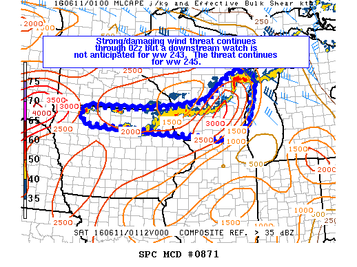
WW 0245 Status Updates STATUS REPORT ON WW 245 SEVERE WEATHER THREAT CONTINUES RIGHT OF A LINE FROM 15 NE LNR TO 25 NNE MSN TO 15 ESE OSH TO GRB TO 40 WNW MBL. FOR ADDITIONAL INFORMATION SEE MESOSCALE DISCUSSION 0871 ..GLEASON..06/11/16 ATTN…WFO…MQT…GRB…MKX… STATUS REPORT FOR WS 245 SEVERE WEATHER THREAT CONTINUES FOR THE FOLLOWING AREAS WIC009-015-021-027-029-039-047-061-071-075-077-078-083-087-089- 111-115-117-131-135-137-139-110240- WI… Read more →

Posted in Archive, Severe Weather Discussions | Tagged Severe Weather, Watches and Warnings, weather
Storm Prediction Center Jun 11, 2016 UTC Evening Outlook

Storm Prediction Center Jun 11, 2016 UTC Evening Outlook

Alomar Sharpe Friday, June 10, 2016 // 8:39 pm

SPC 0100Z Day 1 Outlook DAY 1 CONVECTIVE OUTLOOK NWS STORM PREDICTION CENTER NORMAN OK 0755 PM CDT FRI JUN 10 2016 VALID 110100Z – 111200Z …THERE IS A SLGT RISK OF SEVERE THUNDERSTORMS FOR PORTIONS OF MONTANA… …THERE IS A SLGT RISK OF SEVERE THUNDERSTORMS FOR PORTIONS OF THE WRN GREAT LAKES REGION TO THE UPPER MIDWEST… …THERE IS… Read more →

Posted in Archive, Severe Weather Discussions | Tagged Severe Weather, weather
NOAA Storm Prediction Center Mesoscale Discussion 871

NOAA Storm Prediction Center Mesoscale Discussion 871

Alomar Sharpe Friday, June 10, 2016 // 8:34 pm

MD 0871 CONCERNING SEVERE THUNDERSTORM WATCH 243…245… FOR PORTIONS OF EASTERN/SOUTHERN WI…NRN IA MESOSCALE DISCUSSION 0871 NWS STORM PREDICTION CENTER NORMAN OK 0833 PM CDT FRI JUN 10 2016 AREAS AFFECTED…PORTIONS OF EASTERN/SOUTHERN WI…NRN IA CONCERNING…SEVERE THUNDERSTORM WATCH 243…245… VALID 110133Z – 110330Z THE SEVERE WEATHER THREAT FOR SEVERE THUNDERSTORM WATCH 243…245…CONTINUES. SUMMARY…STRONG/SEVERE THUNDERSTORMS WILL CONTINUE TO POSE A RISK… Read more →

Posted in Archive, Severe Weather Discussions | Tagged Severe Weather, Watches and Warnings, weather
NOAA Storm Prediction Center Mesoscale Discussion 870

NOAA Storm Prediction Center Mesoscale Discussion 870

Alomar Sharpe Friday, June 10, 2016 // 7:03 pm

MD 0870 CONCERNING SEVERE POTENTIAL…WATCH UNLIKELY FOR PORTIONS OF CNTRL/WRN NEB MESOSCALE DISCUSSION 0870 NWS STORM PREDICTION CENTER NORMAN OK 0702 PM CDT FRI JUN 10 2016 AREAS AFFECTED…PORTIONS OF CNTRL/WRN NEB CONCERNING…SEVERE POTENTIAL…WATCH UNLIKELY VALID 110002Z – 110130Z PROBABILITY OF WATCH ISSUANCE…5 PERCENT SUMMARY…AN ISOLATED LARGE HAIL AND STRONG TO LOCALLY DAMAGING WIND THREAT SHOULD CONTINUE FOR THE NEXT… Read more →

Posted in Archive, Severe Weather Discussions | Tagged Severe Weather, Watches and Warnings, weather
NOAA Storm Prediction Center Mesoscale Discussion 869

NOAA Storm Prediction Center Mesoscale Discussion 869

Alomar Sharpe Friday, June 10, 2016 // 7:00 pm

MD 0869 CONCERNING SEVERE POTENTIAL…WATCH UNLIKELY FOR PORTIONS OF WRN LOWER MI…LAKE MICHIGAN MESOSCALE DISCUSSION 0869 NWS STORM PREDICTION CENTER NORMAN OK 0657 PM CDT FRI JUN 10 2016 AREAS AFFECTED…PORTIONS OF WRN LOWER MI…LAKE MICHIGAN CONCERNING…SEVERE POTENTIAL…WATCH UNLIKELY VALID 102357Z – 110200Z PROBABILITY OF WATCH ISSUANCE…20 PERCENT SUMMARY…THUNDERSTORMS MOVING EAST/SOUTHEAST ACROSS WESTERN LOWER MICHIGAN THIS EVENING MAY PRODUCE LOCALLY… Read more →

Posted in Archive, Severe Weather Discussions | Tagged Severe Weather, Watches and Warnings, weather
← Previous 1 … 410 411 412 … 2,028 Next →

Today’s Severe Weather Threat

SVR WX THREAT

Today’s Tornado Threat

SVR WX THREAT

Search The Site

Contributing Scientists

  • Alomar Sharpe
  • Amber Kulick
  • Branden Walker
  • Chris Vagasky
  • Colt Murray
  • Emily Riter
  • Kendall Junker
  • Matt Breland
  • Nick Lilja
  • NickelBlock Staff
  • Noah Gower

Wx Topics

2019 Atlantic Hurricane Season 2020 Atlantic hurricane Season Alabama Weather Amarillo weather Atlantic Hurricane Season Coronavirus COVID-19 COVID19 Earthquakes Flooding Geology Gulf Coast Weather hail hurricanes Louisiana Weather Mississippi Weather rain Severe Weather snow Texas Weather Thunderstorms Tornadoes Tropical Depressions Tropical Storms Tropical Weather tropics USGS Watches and Warnings weather Wind

What We Cover

  • Archive (10,136)
  • Climate (64)
  • Education (230)
  • Environment (8)
  • Forecasting (467)
  • Geology (210)
  • High Plains Weather (119)
  • Midwest Weather (35)
  • Northeast Weather (13)
  • Northwest Weather (5)
  • Not Weather (93)
  • Research (31)
  • River Flooding (23)
  • Severe Weather Discussions (8,640)
  • South Plains Weather (69)
  • Southeast Weather (312)
  • Space (19)
  • Storm Chasing (86)
  • Tropics (450)
  • Weather & Sports (4)
  • Weather & TV (37)
  • Weather History (8)
  • West Coast Weather (4)

Research

  • Conclusion: How multiple variables control TX/OK panhandle Spring severe weather
  • Findings: How multiple variables control TX/OK panhandle Spring severe weather
  • Methods: How multiple variables control TX/OK panhandle Spring severe weather
  • Introduction: How multiple variables control TX/OK panhandle Spring severe weather
  • Works Cited: How multiple variables control TX/OK panhandle Spring severe weather

Popular This Month

  • Remember that “Arctic Blast” people were posting about? Buckle up (6,957)
  • Another “Arctic Blast!” headed to the southeast says social media-rologists (2,420)
  • Arctic blast plunges Mississippi into ice age-like conditions colder than one of the moons of Jupiter (2,410)
  • More cold and snow has South Mississippi feeling like South Manitoba (1,888)
  • More wintry weather possible in South Mississippi next week (1,854)
  • Enough with the “Meteorologists get paid to be wrong” (1,617)
  • Afternoon Update: Snow possible for South Mississippi (960)
  • CIPS Analogs showing thunderstorms, possible severe weather, late next week for south Mississippi (949)
  • Freezing weather won’t kill all mosquitos (664)
  • Jan 16, south Mississippi morning snowfall update (541)
  • Instantly freeze water to make stalagmites (333)
  • Will it snow? A brief look at the steps to get it (318)

Primary Menu

  • About us
    • About us
    • How We Forecast
    • Archives
  • Our Services
    • Live Stream: Severe Weather Discussions
    • Go Storm Chasing
    • Pictures
  • Contact Us!
  • Jobs
  • Weather Safety
    • Weather Safety
    • Hurricane Preparedness Tips
    • Road Conditions
    • Current Conditions
    • South Mississippi river forecasts
    • Forecasting Presentation
  • Login

Secondary Menu

  • Severe Weather Outlook
    • Severe Outlook through Day 8
    • Severe Outlook By State
    • Today’s Severe Weather Threat
    • Today’s Tornado Threat
    • Today’s Severe Wind Threat
    • Today’s Severe Hail Threat
    • Excessive Rainfall Forecasts
  • Short Term Forecast
    • Current Radar & Satellite
    • Detailed National Forecast Discussion
    • National Surface Maps
    • National Temperatures
    • National Precipitation Chances
    • National Precipitation Estimates
    • National Snowfall Estimates
    • National Ice Estimates
    • National Convective Outlook
    • Public RAPTOR Map
    • Model Data Viewer
  • Tropics
  • 10 Day Trend
  • Seasonal Discussion

Copyright © 2026 NickelBlock Forecasting.

Powered by WordPress and Path. Back to Top

Google+
  • About us
  • Our Services
  • Contact Us!
  • Jobs
  • Weather Safety
  • Login