Primary Menu Search
  • About us
    • About us
    • How We Forecast
    • Archives
  • Our Services
    • Live Stream: Severe Weather Discussions
    • Go Storm Chasing
    • Pictures
  • Contact Us!
  • Jobs
  • Weather Safety
    • Weather Safety
    • Hurricane Preparedness Tips
    • Road Conditions
    • Current Conditions
    • South Mississippi river forecasts
    • Forecasting Presentation
  • Login

NickelBlock Forecasting

Funny name. Serious data.

Secondary Menu
  • Severe Weather Outlook
    • Severe Outlook through Day 8
    • Severe Outlook By State
    • Today’s Severe Weather Threat
    • Today’s Tornado Threat
    • Today’s Severe Wind Threat
    • Today’s Severe Hail Threat
    • Excessive Rainfall Forecasts
  • Short Term Forecast
    • Current Radar & Satellite
    • Detailed National Forecast Discussion
    • National Surface Maps
    • National Temperatures
    • National Precipitation Chances
    • National Precipitation Estimates
    • National Snowfall Estimates
    • National Ice Estimates
    • National Convective Outlook
    • Public RAPTOR Map
    • Model Data Viewer
  • Tropics
  • 10 Day Trend
  • Seasonal Discussion
You are here: Home ∼ Page 374

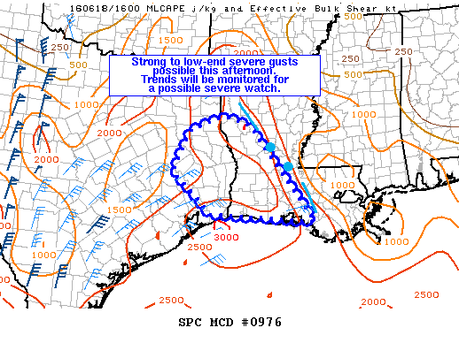
NOAA Storm Prediction Center Severe Thunderstorm Watch 270

Alomar Sharpe Saturday, June 18, 2016 // 1:15 pm

WW 270 SEVERE TSTM LA TX CW 181815Z – 190100Z URGENT – IMMEDIATE BROADCAST REQUESTED SEVERE THUNDERSTORM WATCH NUMBER 270 NWS STORM PREDICTION CENTER NORMAN OK 115 PM CDT SAT JUN 18 2016 THE NWS STORM PREDICTION CENTER HAS ISSUED A * SEVERE THUNDERSTORM WATCH FOR PORTIONS OF WESTERN AND SOUTHERN LOUISIANA EAST TEXAS COASTAL WATERS * EFFECTIVE THIS SATURDAY… Read more →

Posted in Archive, Severe Weather Discussions | Tagged Severe Weather, Watches and Warnings, weather
NOAA Storm Prediction Center Mesoscale Discussion 977

NOAA Storm Prediction Center Mesoscale Discussion 977

Alomar Sharpe Saturday, June 18, 2016 // 12:44 pm

MD 0977 CONCERNING SEVERE POTENTIAL…WATCH UNLIKELY FOR PORTIONS OF THE FL PENINSULA MESOSCALE DISCUSSION 0977 NWS STORM PREDICTION CENTER NORMAN OK 1243 PM CDT SAT JUN 18 2016 AREAS AFFECTED…PORTIONS OF THE FL PENINSULA CONCERNING…SEVERE POTENTIAL…WATCH UNLIKELY VALID 181743Z – 181945Z PROBABILITY OF WATCH ISSUANCE…5 PERCENT SUMMARY…ISOLATED DAMAGING WIND GUSTS ARE POSSIBLE THIS AFTERNOON. COVERAGE AND INTENSITY IS EXPECTED TO… Read more →

Posted in Archive, Severe Weather Discussions | Tagged Severe Weather, Watches and Warnings, weather
NOAA Storm Prediction Center Mesoscale Discussion 976

NOAA Storm Prediction Center Mesoscale Discussion 976

Alomar Sharpe Saturday, June 18, 2016 // 11:32 am

MD 0976 CONCERNING SEVERE POTENTIAL…WATCH POSSIBLE FOR WRN AND SWRN LA / E TX MESOSCALE DISCUSSION 0976 NWS STORM PREDICTION CENTER NORMAN OK 1131 AM CDT SAT JUN 18 2016 AREAS AFFECTED…WRN AND SWRN LA / E TX CONCERNING…SEVERE POTENTIAL…WATCH POSSIBLE VALID 181631Z – 181800Z PROBABILITY OF WATCH ISSUANCE…40 PERCENT SUMMARY…STRONG TO LOW-END SEVERE GUSTS ARE POSSIBLE THIS AFTERNOON. CONVECTIVE… Read more →

Posted in Archive, Severe Weather Discussions | Tagged Severe Weather, Watches and Warnings, weather
Storm Prediction Center Jun 18, 2016 Morning Outlook

Storm Prediction Center Jun 18, 2016 Morning Outlook

Alomar Sharpe Saturday, June 18, 2016 // 8:38 am

SPC 1300Z Day 1 Outlook DAY 1 CONVECTIVE OUTLOOK NWS STORM PREDICTION CENTER NORMAN OK 0734 AM CDT SAT JUN 18 2016 VALID 181300Z – 191200Z …THERE IS AN ENH RISK OF SEVERE THUNDERSTORMS OVER PARTS OF NORTHERN MT AND NORTHWEST ND… …THERE IS A SLGT RISK OF SEVERE THUNDERSTORMS ACROSS PARTS OF THE NORTHERN PLAINS… …THERE IS A MRGL… Read more →

Posted in Archive, Severe Weather Discussions | Tagged Severe Weather, weather
NOAA Storm Prediction Center Mesoscale Discussion 975

NOAA Storm Prediction Center Mesoscale Discussion 975

Alomar Sharpe Saturday, June 18, 2016 // 6:17 am

MD 0975 CONCERNING SEVERE THUNDERSTORM WATCH 269… FOR WESTERN/CENTRAL OK MESOSCALE DISCUSSION 0975 NWS STORM PREDICTION CENTER NORMAN OK 0616 AM CDT SAT JUN 18 2016 AREAS AFFECTED…WESTERN/CENTRAL OK CONCERNING…SEVERE THUNDERSTORM WATCH 269… VALID 181116Z – 181145Z THE SEVERE WEATHER THREAT FOR SEVERE THUNDERSTORM WATCH 269 CONTINUES. SUMMARY…SEVERE RISK HAS BECOME MINIMAL WITHIN WW 269. STRONG WIND GUSTS MAY STILL… Read more →

Posted in Archive, Severe Weather Discussions | Tagged Severe Weather, Watches and Warnings, weather
← Previous 1 … 373 374 375 … 2,028 Next →

Today’s Severe Weather Threat

SVR WX THREAT

Today’s Tornado Threat

SVR WX THREAT

Search The Site

Contributing Scientists

  • Alomar Sharpe
  • Amber Kulick
  • Branden Walker
  • Chris Vagasky
  • Colt Murray
  • Emily Riter
  • Kendall Junker
  • Matt Breland
  • Nick Lilja
  • NickelBlock Staff
  • Noah Gower

Wx Topics

2019 Atlantic Hurricane Season 2020 Atlantic hurricane Season Alabama Weather Amarillo weather Atlantic Hurricane Season Coronavirus COVID-19 COVID19 Earthquakes Flooding Geology Gulf Coast Weather hail hurricanes Louisiana Weather Mississippi Weather rain Severe Weather snow Texas Weather Thunderstorms Tornadoes Tropical Depressions Tropical Storms Tropical Weather tropics USGS Watches and Warnings weather Wind

What We Cover

  • Archive (10,136)
  • Climate (64)
  • Education (230)
  • Environment (8)
  • Forecasting (467)
  • Geology (210)
  • High Plains Weather (119)
  • Midwest Weather (35)
  • Northeast Weather (13)
  • Northwest Weather (5)
  • Not Weather (93)
  • Research (31)
  • River Flooding (23)
  • Severe Weather Discussions (8,640)
  • South Plains Weather (69)
  • Southeast Weather (312)
  • Space (19)
  • Storm Chasing (86)
  • Tropics (450)
  • Weather & Sports (4)
  • Weather & TV (37)
  • Weather History (8)
  • West Coast Weather (4)

Research

  • Conclusion: How multiple variables control TX/OK panhandle Spring severe weather
  • Findings: How multiple variables control TX/OK panhandle Spring severe weather
  • Methods: How multiple variables control TX/OK panhandle Spring severe weather
  • Introduction: How multiple variables control TX/OK panhandle Spring severe weather
  • Works Cited: How multiple variables control TX/OK panhandle Spring severe weather

Popular This Month

  • Remember that “Arctic Blast” people were posting about? Buckle up (6,957)
  • Another “Arctic Blast!” headed to the southeast says social media-rologists (2,420)
  • Arctic blast plunges Mississippi into ice age-like conditions colder than one of the moons of Jupiter (2,410)
  • More cold and snow has South Mississippi feeling like South Manitoba (1,888)
  • More wintry weather possible in South Mississippi next week (1,854)
  • Enough with the “Meteorologists get paid to be wrong” (1,617)
  • Afternoon Update: Snow possible for South Mississippi (960)
  • CIPS Analogs showing thunderstorms, possible severe weather, late next week for south Mississippi (949)
  • Freezing weather won’t kill all mosquitos (664)
  • Jan 16, south Mississippi morning snowfall update (541)
  • Instantly freeze water to make stalagmites (333)
  • Will it snow? A brief look at the steps to get it (318)

Primary Menu

  • About us
    • About us
    • How We Forecast
    • Archives
  • Our Services
    • Live Stream: Severe Weather Discussions
    • Go Storm Chasing
    • Pictures
  • Contact Us!
  • Jobs
  • Weather Safety
    • Weather Safety
    • Hurricane Preparedness Tips
    • Road Conditions
    • Current Conditions
    • South Mississippi river forecasts
    • Forecasting Presentation
  • Login

Secondary Menu

  • Severe Weather Outlook
    • Severe Outlook through Day 8
    • Severe Outlook By State
    • Today’s Severe Weather Threat
    • Today’s Tornado Threat
    • Today’s Severe Wind Threat
    • Today’s Severe Hail Threat
    • Excessive Rainfall Forecasts
  • Short Term Forecast
    • Current Radar & Satellite
    • Detailed National Forecast Discussion
    • National Surface Maps
    • National Temperatures
    • National Precipitation Chances
    • National Precipitation Estimates
    • National Snowfall Estimates
    • National Ice Estimates
    • National Convective Outlook
    • Public RAPTOR Map
    • Model Data Viewer
  • Tropics
  • 10 Day Trend
  • Seasonal Discussion

Copyright © 2026 NickelBlock Forecasting.

Powered by WordPress and Path. Back to Top

Google+
  • About us
  • Our Services
  • Contact Us!
  • Jobs
  • Weather Safety
  • Login