Primary Menu Search
  • About us
    • About us
    • How We Forecast
    • Archives
  • Our Services
    • Live Stream: Severe Weather Discussions
    • Go Storm Chasing
    • Pictures
  • Contact Us!
  • Jobs
  • Weather Safety
    • Weather Safety
    • Hurricane Preparedness Tips
    • Road Conditions
    • Current Conditions
    • South Mississippi river forecasts
    • Forecasting Presentation
  • Login

NickelBlock Forecasting

Funny name. Serious data.

Secondary Menu
  • Severe Weather Outlook
    • Severe Outlook through Day 8
    • Severe Outlook By State
    • Today’s Severe Weather Threat
    • Today’s Tornado Threat
    • Today’s Severe Wind Threat
    • Today’s Severe Hail Threat
    • Excessive Rainfall Forecasts
  • Short Term Forecast
    • Current Radar & Satellite
    • Detailed National Forecast Discussion
    • National Surface Maps
    • National Temperatures
    • National Precipitation Chances
    • National Precipitation Estimates
    • National Snowfall Estimates
    • National Ice Estimates
    • National Convective Outlook
    • Public RAPTOR Map
    • Model Data Viewer
  • Tropics
  • 10 Day Trend
  • Seasonal Discussion
You are here: Home ∼ Page 341
Storm Prediction Center Jun 26, 2016 Morning Outlook

Storm Prediction Center Jun 26, 2016 Morning Outlook

Alomar Sharpe Sunday, June 26, 2016 // 8:38 am

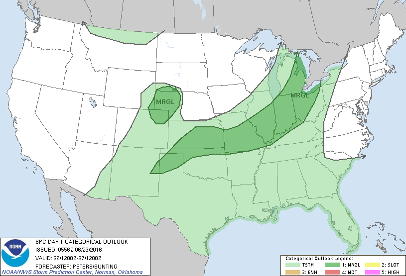
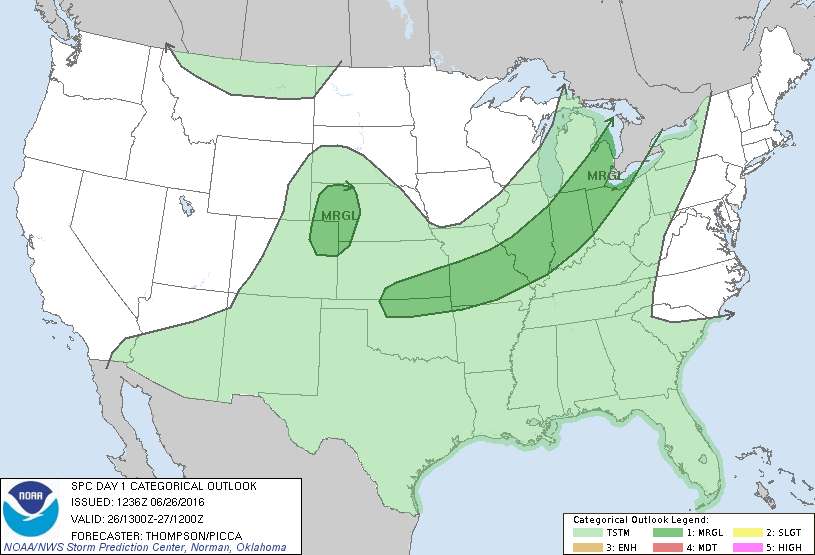
SPC 1300Z Day 1 Outlook DAY 1 CONVECTIVE OUTLOOK NWS STORM PREDICTION CENTER NORMAN OK 0736 AM CDT SUN JUN 26 2016 VALID 261300Z – 271200Z …THERE IS A MRGL RISK OF SEVERE THUNDERSTORMS THIS AFTERNOON FROM SE LOWER MI SWWD TO THE KS/OK BORDER… …THERE IS A MRGL RISK OF SEVERE THUNDERSTORMS THIS AFTERNOON/EVENING FROM NE CO INTO WRN… Read more →

Posted in Archive, Severe Weather Discussions | Tagged Severe Weather, weather
Storm Prediction Center Jun 26, 2016 Early Morning UTC Day 1 Convective Outlook

Storm Prediction Center Jun 26, 2016 Early Morning UTC Day 1 Convective Outlook

Alomar Sharpe Sunday, June 26, 2016 // 1:38 am

SPC 1200Z Day 1 Outlook DAY 1 CONVECTIVE OUTLOOK NWS STORM PREDICTION CENTER NORMAN OK 1256 AM CDT SUN JUN 26 2016 VALID 261200Z – 271200Z …THERE IS A MRGL RISK OF SEVERE THUNDERSTORMS EXTENDING FROM LOWER MI THROUGH THE MIDWEST AND MID MS VALLEY TO KS/NORTHERN OK AND PART OF THE SOUTHERN HIGH PLAINS… …THERE IS A MRGL RISK… Read more →

Posted in Archive, Severe Weather Discussions | Tagged Severe Weather, weather
NOAA Storm Prediction Center Mesoscale Discussion 1059

NOAA Storm Prediction Center Mesoscale Discussion 1059

Alomar Sharpe Saturday, June 25, 2016 // 10:44 pm

MD 1059 CONCERNING SEVERE THUNDERSTORM WATCH 299…300… FOR NRN WI…WRN UPPER MI MESOSCALE DISCUSSION 1059 NWS STORM PREDICTION CENTER NORMAN OK 1043 PM CDT SAT JUN 25 2016 AREAS AFFECTED…NRN WI…WRN UPPER MI CONCERNING…SEVERE THUNDERSTORM WATCH 299…300… VALID 260343Z – 260515Z THE SEVERE WEATHER THREAT FOR SEVERE THUNDERSTORM WATCH 299…300…CONTINUES. SUMMARY…A FEW DAMAGING WIND GUSTS ARE POSSIBLE BUT THE OVERALL… Read more →

Posted in Archive, Severe Weather Discussions | Tagged Severe Weather, Watches and Warnings, weather
NOAA Storm Prediction Center Mesoscale Discussion 1058

NOAA Storm Prediction Center Mesoscale Discussion 1058

Alomar Sharpe Saturday, June 25, 2016 // 9:58 pm

MD 1058 CONCERNING SEVERE POTENTIAL…WATCH UNLIKELY FOR MUCH OF IOWA MESOSCALE DISCUSSION 1058 NWS STORM PREDICTION CENTER NORMAN OK 0957 PM CDT SAT JUN 25 2016 AREAS AFFECTED…MUCH OF IOWA CONCERNING…SEVERE POTENTIAL…WATCH UNLIKELY VALID 260257Z – 260530Z PROBABILITY OF WATCH ISSUANCE…20 PERCENT SUMMARY…THUNDERSTORMS DEVELOPING ALONG A COLD FRONT OVER NORTHERN IOWA WILL LIKELY EXPAND IN COVERAGE…AND THE STRONGER STORMS MAY… Read more →

Posted in Archive, Severe Weather Discussions | Tagged Severe Weather, Watches and Warnings, weather
← Previous 1 … 340 341 342 … 2,028 Next →

Today’s Severe Weather Threat

SVR WX THREAT

Today’s Tornado Threat

SVR WX THREAT

Search The Site

Contributing Scientists

  • Alomar Sharpe
  • Amber Kulick
  • Branden Walker
  • Chris Vagasky
  • Colt Murray
  • Emily Riter
  • Kendall Junker
  • Matt Breland
  • Nick Lilja
  • NickelBlock Staff
  • Noah Gower

Wx Topics

2019 Atlantic Hurricane Season 2020 Atlantic hurricane Season Alabama Weather Amarillo weather Atlantic Hurricane Season Coronavirus COVID-19 COVID19 Earthquakes Flooding Geology Gulf Coast Weather hail hurricanes Louisiana Weather Mississippi Weather rain Severe Weather snow Texas Weather Thunderstorms Tornadoes Tropical Depressions Tropical Storms Tropical Weather tropics USGS Watches and Warnings weather Wind

What We Cover

  • Archive (10,136)
  • Climate (64)
  • Education (230)
  • Environment (8)
  • Forecasting (467)
  • Geology (210)
  • High Plains Weather (119)
  • Midwest Weather (35)
  • Northeast Weather (13)
  • Northwest Weather (5)
  • Not Weather (93)
  • Research (31)
  • River Flooding (23)
  • Severe Weather Discussions (8,640)
  • South Plains Weather (69)
  • Southeast Weather (312)
  • Space (19)
  • Storm Chasing (86)
  • Tropics (450)
  • Weather & Sports (4)
  • Weather & TV (37)
  • Weather History (8)
  • West Coast Weather (4)

Research

  • Conclusion: How multiple variables control TX/OK panhandle Spring severe weather
  • Findings: How multiple variables control TX/OK panhandle Spring severe weather
  • Methods: How multiple variables control TX/OK panhandle Spring severe weather
  • Introduction: How multiple variables control TX/OK panhandle Spring severe weather
  • Works Cited: How multiple variables control TX/OK panhandle Spring severe weather

Popular This Month

  • Remember that “Arctic Blast” people were posting about? Buckle up (6,957)
  • Another “Arctic Blast!” headed to the southeast says social media-rologists (2,420)
  • Arctic blast plunges Mississippi into ice age-like conditions colder than one of the moons of Jupiter (2,410)
  • More cold and snow has South Mississippi feeling like South Manitoba (1,888)
  • More wintry weather possible in South Mississippi next week (1,854)
  • Enough with the “Meteorologists get paid to be wrong” (1,617)
  • Afternoon Update: Snow possible for South Mississippi (960)
  • CIPS Analogs showing thunderstorms, possible severe weather, late next week for south Mississippi (949)
  • Freezing weather won’t kill all mosquitos (664)
  • Jan 16, south Mississippi morning snowfall update (541)
  • Instantly freeze water to make stalagmites (333)
  • Will it snow? A brief look at the steps to get it (318)

Primary Menu

  • About us
    • About us
    • How We Forecast
    • Archives
  • Our Services
    • Live Stream: Severe Weather Discussions
    • Go Storm Chasing
    • Pictures
  • Contact Us!
  • Jobs
  • Weather Safety
    • Weather Safety
    • Hurricane Preparedness Tips
    • Road Conditions
    • Current Conditions
    • South Mississippi river forecasts
    • Forecasting Presentation
  • Login

Secondary Menu

  • Severe Weather Outlook
    • Severe Outlook through Day 8
    • Severe Outlook By State
    • Today’s Severe Weather Threat
    • Today’s Tornado Threat
    • Today’s Severe Wind Threat
    • Today’s Severe Hail Threat
    • Excessive Rainfall Forecasts
  • Short Term Forecast
    • Current Radar & Satellite
    • Detailed National Forecast Discussion
    • National Surface Maps
    • National Temperatures
    • National Precipitation Chances
    • National Precipitation Estimates
    • National Snowfall Estimates
    • National Ice Estimates
    • National Convective Outlook
    • Public RAPTOR Map
    • Model Data Viewer
  • Tropics
  • 10 Day Trend
  • Seasonal Discussion

Copyright © 2026 NickelBlock Forecasting.

Powered by WordPress and Path. Back to Top

Google+
  • About us
  • Our Services
  • Contact Us!
  • Jobs
  • Weather Safety
  • Login