Primary Menu Search
  • About us
    • About us
    • How We Forecast
    • Archives
  • Our Services
    • Live Stream: Severe Weather Discussions
    • Go Storm Chasing
    • Pictures
  • Contact Us!
  • Jobs
  • Weather Safety
    • Weather Safety
    • Hurricane Preparedness Tips
    • Road Conditions
    • Current Conditions
    • South Mississippi river forecasts
    • Forecasting Presentation
  • Login

NickelBlock Forecasting

Funny name. Serious data.

Secondary Menu
  • Severe Weather Outlook
    • Severe Outlook through Day 8
    • Severe Outlook By State
    • Today’s Severe Weather Threat
    • Today’s Tornado Threat
    • Today’s Severe Wind Threat
    • Today’s Severe Hail Threat
    • Excessive Rainfall Forecasts
  • Short Term Forecast
    • Current Radar & Satellite
    • Detailed National Forecast Discussion
    • National Surface Maps
    • National Temperatures
    • National Precipitation Chances
    • National Precipitation Estimates
    • National Snowfall Estimates
    • National Ice Estimates
    • National Convective Outlook
    • Public RAPTOR Map
    • Model Data Viewer
  • Tropics
  • 10 Day Trend
  • Seasonal Discussion
You are here: Home ∼ Page 335

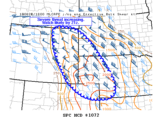
NOAA Storm Prediction Center Severe Thunderstorm Watch 304

Alomar Sharpe Tuesday, June 28, 2016 // 2:40 pm

WW 304 SEVERE TSTM CO NE SD WY 281940Z – 290300Z URGENT – IMMEDIATE BROADCAST REQUESTED SEVERE THUNDERSTORM WATCH NUMBER 304 NWS STORM PREDICTION CENTER NORMAN OK 240 PM CDT TUE JUN 28 2016 THE NWS STORM PREDICTION CENTER HAS ISSUED A * SEVERE THUNDERSTORM WATCH FOR PORTIONS OF NORTHEAST COLORADO WESTERN AND CENTRAL NEBRASKA SOUTHWEST SOUTH DAKOTA EASTERN WYOMING… Read more →

Posted in Archive, Severe Weather Discussions | Tagged Severe Weather, Watches and Warnings, weather
NOAA Storm Prediction Center Mesoscale Discussion 1072

NOAA Storm Prediction Center Mesoscale Discussion 1072

Alomar Sharpe Tuesday, June 28, 2016 // 1:56 pm

MD 1072 CONCERNING SEVERE POTENTIAL…WATCH LIKELY FOR EASTERN WY…SOUTHWEST SD…WESTERN NEB…NORTHEAST CO MESOSCALE DISCUSSION 1072 NWS STORM PREDICTION CENTER NORMAN OK 0155 PM CDT TUE JUN 28 2016 AREAS AFFECTED…EASTERN WY…SOUTHWEST SD…WESTERN NEB…NORTHEAST CO CONCERNING…SEVERE POTENTIAL…WATCH LIKELY VALID 281855Z – 282030Z PROBABILITY OF WATCH ISSUANCE…80 PERCENT SUMMARY…THUNDERSTORM DEVELOPMENT IS EXPECTED TO BECOME MORE WIDESPREAD THIS AFTERNOON. A WATCH WILL LIKELY… Read more →

Posted in Archive, Severe Weather Discussions | Tagged Severe Weather, Watches and Warnings, weather
NOAA Storm Prediction Center Mesoscale Discussion 1071

NOAA Storm Prediction Center Mesoscale Discussion 1071

Alomar Sharpe Tuesday, June 28, 2016 // 12:33 pm

MD 1071 CONCERNING SEVERE POTENTIAL…WATCH POSSIBLE FOR NORTHEAST WY INTO SOUTHWEST SD MESOSCALE DISCUSSION 1071 NWS STORM PREDICTION CENTER NORMAN OK 1232 PM CDT TUE JUN 28 2016 AREAS AFFECTED…NORTHEAST WY INTO SOUTHWEST SD CONCERNING…SEVERE POTENTIAL…WATCH POSSIBLE VALID 281732Z – 281830Z PROBABILITY OF WATCH ISSUANCE…40 PERCENT SUMMARY…ISOLATED STRONG TO SEVERE THUNDERSTORMS ARE POSSIBLE EARLY THIS AFTERNOON ACROSS THE BLACK HILLS…. Read more →

Posted in Archive, Severe Weather Discussions | Tagged Severe Weather, Watches and Warnings, weather
NOAA Storm Prediction Center Mesoscale Discussion 1070

NOAA Storm Prediction Center Mesoscale Discussion 1070

Alomar Sharpe Tuesday, June 28, 2016 // 12:10 pm

MD 1070 CONCERNING SEVERE POTENTIAL…WATCH POSSIBLE FOR NRN VT TO NERN PA MESOSCALE DISCUSSION 1070 NWS STORM PREDICTION CENTER NORMAN OK 1209 PM CDT TUE JUN 28 2016 AREAS AFFECTED…NRN VT TO NERN PA CONCERNING…SEVERE POTENTIAL…WATCH POSSIBLE VALID 281709Z – 281815Z PROBABILITY OF WATCH ISSUANCE…40 PERCENT SUMMARY…SCT STRONG STORMS ARE POSSIBLE FROM CNTRL PENNSYLVANIA…NEWD INTO NRN VT. GUSTY WINDS ARE… Read more →

Posted in Archive, Severe Weather Discussions | Tagged Severe Weather, Watches and Warnings, weather
Storm Prediction Center Jun 28, 2016 Morning Outlook

Storm Prediction Center Jun 28, 2016 Morning Outlook

Alomar Sharpe Tuesday, June 28, 2016 // 8:37 am

SPC 1300Z Day 1 Outlook DAY 1 CONVECTIVE OUTLOOK NWS STORM PREDICTION CENTER NORMAN OK 0744 AM CDT TUE JUN 28 2016 VALID 281300Z – 291200Z …THERE IS A SLGT RISK OF SEVERE THUNDERSTORMS THIS AFTERNOON INTO TONIGHT ACROSS PARTS OF THE NRN/CENTRAL HIGH PLAINS… …THERE IS A SLGT RISK OF SEVERE THUNDERSTORMS THIS AFTERNOON/EVENING FROM ERN PA INTO ERN… Read more →

Posted in Archive, Severe Weather Discussions | Tagged Severe Weather, weather
← Previous 1 … 334 335 336 … 2,028 Next →

Today’s Severe Weather Threat

SVR WX THREAT

Today’s Tornado Threat

SVR WX THREAT

Search The Site

Contributing Scientists

  • Alomar Sharpe
  • Amber Kulick
  • Branden Walker
  • Chris Vagasky
  • Colt Murray
  • Emily Riter
  • Kendall Junker
  • Matt Breland
  • Nick Lilja
  • NickelBlock Staff
  • Noah Gower

Wx Topics

2019 Atlantic Hurricane Season 2020 Atlantic hurricane Season Alabama Weather Amarillo weather Atlantic Hurricane Season Coronavirus COVID-19 COVID19 Earthquakes Flooding Geology Gulf Coast Weather hail hurricanes Louisiana Weather Mississippi Weather rain Severe Weather snow Texas Weather Thunderstorms Tornadoes Tropical Depressions Tropical Storms Tropical Weather tropics USGS Watches and Warnings weather Wind

What We Cover

  • Archive (10,136)
  • Climate (64)
  • Education (230)
  • Environment (8)
  • Forecasting (467)
  • Geology (210)
  • High Plains Weather (119)
  • Midwest Weather (35)
  • Northeast Weather (13)
  • Northwest Weather (5)
  • Not Weather (93)
  • Research (31)
  • River Flooding (23)
  • Severe Weather Discussions (8,640)
  • South Plains Weather (69)
  • Southeast Weather (312)
  • Space (19)
  • Storm Chasing (86)
  • Tropics (450)
  • Weather & Sports (4)
  • Weather & TV (37)
  • Weather History (8)
  • West Coast Weather (4)

Research

  • Conclusion: How multiple variables control TX/OK panhandle Spring severe weather
  • Findings: How multiple variables control TX/OK panhandle Spring severe weather
  • Methods: How multiple variables control TX/OK panhandle Spring severe weather
  • Introduction: How multiple variables control TX/OK panhandle Spring severe weather
  • Works Cited: How multiple variables control TX/OK panhandle Spring severe weather

Popular This Month

  • Remember that “Arctic Blast” people were posting about? Buckle up (6,957)
  • Another “Arctic Blast!” headed to the southeast says social media-rologists (2,420)
  • Arctic blast plunges Mississippi into ice age-like conditions colder than one of the moons of Jupiter (2,410)
  • More cold and snow has South Mississippi feeling like South Manitoba (1,888)
  • More wintry weather possible in South Mississippi next week (1,854)
  • Enough with the “Meteorologists get paid to be wrong” (1,617)
  • Afternoon Update: Snow possible for South Mississippi (960)
  • CIPS Analogs showing thunderstorms, possible severe weather, late next week for south Mississippi (949)
  • Freezing weather won’t kill all mosquitos (664)
  • Jan 16, south Mississippi morning snowfall update (541)
  • Instantly freeze water to make stalagmites (333)
  • Will it snow? A brief look at the steps to get it (318)

Primary Menu

  • About us
    • About us
    • How We Forecast
    • Archives
  • Our Services
    • Live Stream: Severe Weather Discussions
    • Go Storm Chasing
    • Pictures
  • Contact Us!
  • Jobs
  • Weather Safety
    • Weather Safety
    • Hurricane Preparedness Tips
    • Road Conditions
    • Current Conditions
    • South Mississippi river forecasts
    • Forecasting Presentation
  • Login

Secondary Menu

  • Severe Weather Outlook
    • Severe Outlook through Day 8
    • Severe Outlook By State
    • Today’s Severe Weather Threat
    • Today’s Tornado Threat
    • Today’s Severe Wind Threat
    • Today’s Severe Hail Threat
    • Excessive Rainfall Forecasts
  • Short Term Forecast
    • Current Radar & Satellite
    • Detailed National Forecast Discussion
    • National Surface Maps
    • National Temperatures
    • National Precipitation Chances
    • National Precipitation Estimates
    • National Snowfall Estimates
    • National Ice Estimates
    • National Convective Outlook
    • Public RAPTOR Map
    • Model Data Viewer
  • Tropics
  • 10 Day Trend
  • Seasonal Discussion

Copyright © 2026 NickelBlock Forecasting.

Powered by WordPress and Path. Back to Top

Google+
  • About us
  • Our Services
  • Contact Us!
  • Jobs
  • Weather Safety
  • Login