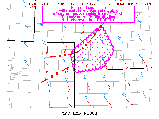
NOAA Storm Prediction Center Mesoscale Discussion 1083
MD 1083 CONCERNING SEVERE THUNDERSTORM WATCH 307… FOR SWRN NEB MESOSCALE DISCUSSION 1083 NWS STORM PREDICTION CENTER NORMAN OK 0944 PM CDT TUE JUN 28 2016 AREAS AFFECTED…SWRN NEB CONCERNING…SEVERE THUNDERSTORM WATCH 307… VALID 290244Z – 290345Z THE SEVERE WEATHER THREAT FOR SEVERE THUNDERSTORM WATCH 307 CONTINUES. SUMMARY…HIGH-END SQUALL LINE WILL RESULT IN WIDESPREAD SWATHS OF SEVERE GUSTS RANGING FROM… Read more →