Primary Menu Search
  • About us
    • About us
    • How We Forecast
    • Archives
  • Our Services
    • Live Stream: Severe Weather Discussions
    • Go Storm Chasing
    • Pictures
  • Contact Us!
  • Jobs
  • Weather Safety
    • Weather Safety
    • Hurricane Preparedness Tips
    • Road Conditions
    • Current Conditions
    • South Mississippi river forecasts
    • Forecasting Presentation
  • Login

NickelBlock Forecasting

Funny name. Serious data.

Secondary Menu
  • Severe Weather Outlook
    • Severe Outlook through Day 8
    • Severe Outlook By State
    • Today’s Severe Weather Threat
    • Today’s Tornado Threat
    • Today’s Severe Wind Threat
    • Today’s Severe Hail Threat
    • Excessive Rainfall Forecasts
  • Short Term Forecast
    • Current Radar & Satellite
    • Detailed National Forecast Discussion
    • National Surface Maps
    • National Temperatures
    • National Precipitation Chances
    • National Precipitation Estimates
    • National Snowfall Estimates
    • National Ice Estimates
    • National Convective Outlook
    • Public RAPTOR Map
    • Model Data Viewer
  • Tropics
  • 10 Day Trend
  • Seasonal Discussion
You are here: Home ∼ Page 285

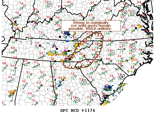
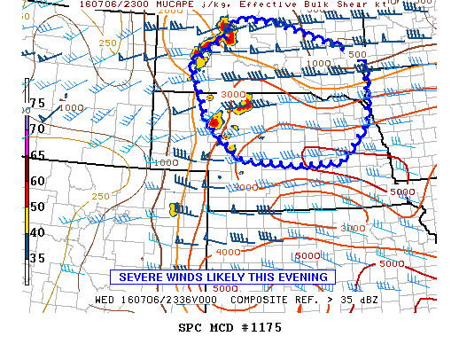
NOAA Storm Prediction Center Severe Thunderstorm Watch 342

Alomar Sharpe Wednesday, July 6, 2016 // 7:40 pm

WW 342 SEVERE TSTM IA MN NE SD 070040Z – 070700Z URGENT – IMMEDIATE BROADCAST REQUESTED SEVERE THUNDERSTORM WATCH NUMBER 342 NWS STORM PREDICTION CENTER NORMAN OK 740 PM CDT WED JUL 6 2016 THE NWS STORM PREDICTION CENTER HAS ISSUED A * SEVERE THUNDERSTORM WATCH FOR PORTIONS OF NORTHWEST IOWA SOUTHWEST MINNESOTA NORTHEAST NEBRASKA EASTERN SOUTH DAKOTA * EFFECTIVE… Read more →

Posted in Archive, Severe Weather Discussions | Tagged Severe Weather, Watches and Warnings, weather
NOAA Storm Prediction Center Mesoscale Discussion 1176

NOAA Storm Prediction Center Mesoscale Discussion 1176

Alomar Sharpe Wednesday, July 6, 2016 // 6:52 pm

MD 1176 CONCERNING SEVERE POTENTIAL…WATCH UNLIKELY FOR WRN NC…SWRN VA…WRN SC…FAR NWRN GA…NERN TN MESOSCALE DISCUSSION 1176 NWS STORM PREDICTION CENTER NORMAN OK 0651 PM CDT WED JUL 06 2016 AREAS AFFECTED…WRN NC…SWRN VA…WRN SC…FAR NWRN GA…NERN TN CONCERNING…SEVERE POTENTIAL…WATCH UNLIKELY VALID 062351Z – 070045Z PROBABILITY OF WATCH ISSUANCE…20 PERCENT SUMMARY…A THREAT FOR STRONG TO MARGINALLY SVR WIND GUSTS MAY… Read more →

Posted in Archive, Severe Weather Discussions | Tagged Severe Weather, Watches and Warnings, weather
NOAA Storm Prediction Center Mesoscale Discussion 1175

NOAA Storm Prediction Center Mesoscale Discussion 1175

Alomar Sharpe Wednesday, July 6, 2016 // 6:49 pm

MD 1175 CONCERNING TORNADO WATCH 340…341… FOR CNTRL SD INTO NEB MESOSCALE DISCUSSION 1175 NWS STORM PREDICTION CENTER NORMAN OK 0648 PM CDT WED JUL 06 2016 AREAS AFFECTED…CNTRL SD INTO NEB CONCERNING…TORNADO WATCH 340…341… VALID 062348Z – 070045Z THE SEVERE WEATHER THREAT FOR TORNADO WATCH 340…341…CONTINUES. SUMMARY…THE THREAT FOR ISOLATED TORNADOES…DAMAGING WINDS…AND HAIL PERSISTS FROM CNTRL SD INTO NEB… Read more →

Posted in Archive, Severe Weather Discussions | Tagged Severe Weather, Watches and Warnings, weather

NOAA Storm Prediction Center Severe Thunderstorm Watch 341

Alomar Sharpe Wednesday, July 6, 2016 // 5:09 pm

WW 341 SEVERE TSTM CO KS NE 062050Z – 070300Z URGENT – IMMEDIATE BROADCAST REQUESTED SEVERE THUNDERSTORM WATCH NUMBER 341 NWS STORM PREDICTION CENTER NORMAN OK 350 PM CDT WED JUL 6 2016 THE NWS STORM PREDICTION CENTER HAS ISSUED A * SEVERE THUNDERSTORM WATCH FOR PORTIONS OF FAR NORTHEAST COLORADO NORTHWEST KANSAS WESTERN AND CENTRAL NEBRASKA * EFFECTIVE THIS… Read more →

Posted in Archive, Severe Weather Discussions | Tagged Severe Weather, Watches and Warnings, weather

NOAA Storm Prediction Center Tornado Watch 340

Alomar Sharpe Wednesday, July 6, 2016 // 5:07 pm

WW 340 TORNADO NE SD WY CW 062015Z – 070300Z URGENT – IMMEDIATE BROADCAST REQUESTED TORNADO WATCH NUMBER 340 NWS STORM PREDICTION CENTER NORMAN OK 315 PM CDT WED JUL 6 2016 THE NWS STORM PREDICTION CENTER HAS ISSUED A * TORNADO WATCH FOR PORTIONS OF NORTHERN NEBRASKA WESTERN SOUTH DAKOTA FAR NORTHEAST WYOMING * EFFECTIVE THIS WEDNESDAY AFTERNOON AND… Read more →

Posted in Archive, Severe Weather Discussions | Tagged Severe Weather, Watches and Warnings, weather
← Previous 1 … 284 285 286 … 2,028 Next →

Today’s Severe Weather Threat

SVR WX THREAT

Today’s Tornado Threat

SVR WX THREAT

Search The Site

Contributing Scientists

  • Alomar Sharpe
  • Amber Kulick
  • Branden Walker
  • Chris Vagasky
  • Colt Murray
  • Emily Riter
  • Kendall Junker
  • Matt Breland
  • Nick Lilja
  • NickelBlock Staff
  • Noah Gower

Wx Topics

2019 Atlantic Hurricane Season 2020 Atlantic hurricane Season Alabama Weather Amarillo weather Atlantic Hurricane Season Coronavirus COVID-19 COVID19 Earthquakes Flooding Geology Gulf Coast Weather hail hurricanes Louisiana Weather Mississippi Weather rain Severe Weather snow Texas Weather Thunderstorms Tornadoes Tropical Depressions Tropical Storms Tropical Weather tropics USGS Watches and Warnings weather Wind

What We Cover

  • Archive (10,136)
  • Climate (64)
  • Education (230)
  • Environment (8)
  • Forecasting (467)
  • Geology (210)
  • High Plains Weather (119)
  • Midwest Weather (35)
  • Northeast Weather (13)
  • Northwest Weather (5)
  • Not Weather (93)
  • Research (31)
  • River Flooding (23)
  • Severe Weather Discussions (8,640)
  • South Plains Weather (69)
  • Southeast Weather (312)
  • Space (19)
  • Storm Chasing (86)
  • Tropics (450)
  • Weather & Sports (4)
  • Weather & TV (37)
  • Weather History (8)
  • West Coast Weather (4)

Research

  • Conclusion: How multiple variables control TX/OK panhandle Spring severe weather
  • Findings: How multiple variables control TX/OK panhandle Spring severe weather
  • Methods: How multiple variables control TX/OK panhandle Spring severe weather
  • Introduction: How multiple variables control TX/OK panhandle Spring severe weather
  • Works Cited: How multiple variables control TX/OK panhandle Spring severe weather

Popular This Month

  • Remember that “Arctic Blast” people were posting about? Buckle up (6,957)
  • Another “Arctic Blast!” headed to the southeast says social media-rologists (2,420)
  • Arctic blast plunges Mississippi into ice age-like conditions colder than one of the moons of Jupiter (2,410)
  • More cold and snow has South Mississippi feeling like South Manitoba (1,888)
  • More wintry weather possible in South Mississippi next week (1,854)
  • Enough with the “Meteorologists get paid to be wrong” (1,617)
  • Afternoon Update: Snow possible for South Mississippi (960)
  • CIPS Analogs showing thunderstorms, possible severe weather, late next week for south Mississippi (949)
  • Freezing weather won’t kill all mosquitos (664)
  • Jan 16, south Mississippi morning snowfall update (541)
  • Instantly freeze water to make stalagmites (333)
  • Will it snow? A brief look at the steps to get it (318)

Primary Menu

  • About us
    • About us
    • How We Forecast
    • Archives
  • Our Services
    • Live Stream: Severe Weather Discussions
    • Go Storm Chasing
    • Pictures
  • Contact Us!
  • Jobs
  • Weather Safety
    • Weather Safety
    • Hurricane Preparedness Tips
    • Road Conditions
    • Current Conditions
    • South Mississippi river forecasts
    • Forecasting Presentation
  • Login

Secondary Menu

  • Severe Weather Outlook
    • Severe Outlook through Day 8
    • Severe Outlook By State
    • Today’s Severe Weather Threat
    • Today’s Tornado Threat
    • Today’s Severe Wind Threat
    • Today’s Severe Hail Threat
    • Excessive Rainfall Forecasts
  • Short Term Forecast
    • Current Radar & Satellite
    • Detailed National Forecast Discussion
    • National Surface Maps
    • National Temperatures
    • National Precipitation Chances
    • National Precipitation Estimates
    • National Snowfall Estimates
    • National Ice Estimates
    • National Convective Outlook
    • Public RAPTOR Map
    • Model Data Viewer
  • Tropics
  • 10 Day Trend
  • Seasonal Discussion

Copyright © 2026 NickelBlock Forecasting.

Powered by WordPress and Path. Back to Top

Google+
  • About us
  • Our Services
  • Contact Us!
  • Jobs
  • Weather Safety
  • Login