Primary Menu Search
  • About us
    • About us
    • How We Forecast
    • Archives
  • Our Services
    • Live Stream: Severe Weather Discussions
    • Go Storm Chasing
    • Pictures
  • Contact Us!
  • Jobs
  • Weather Safety
    • Weather Safety
    • Hurricane Preparedness Tips
    • Road Conditions
    • Current Conditions
    • South Mississippi river forecasts
    • Forecasting Presentation
  • Login

NickelBlock Forecasting

Funny name. Serious data.

Secondary Menu
  • Severe Weather Outlook
    • Severe Outlook through Day 8
    • Severe Outlook By State
    • Today’s Severe Weather Threat
    • Today’s Tornado Threat
    • Today’s Severe Wind Threat
    • Today’s Severe Hail Threat
    • Excessive Rainfall Forecasts
  • Short Term Forecast
    • Current Radar & Satellite
    • Detailed National Forecast Discussion
    • National Surface Maps
    • National Temperatures
    • National Precipitation Chances
    • National Precipitation Estimates
    • National Snowfall Estimates
    • National Ice Estimates
    • National Convective Outlook
    • Public RAPTOR Map
    • Model Data Viewer
  • Tropics
  • 10 Day Trend
  • Seasonal Discussion
You are here: Home ∼ Page 278

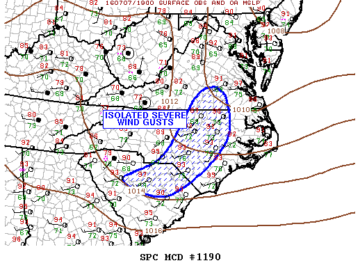
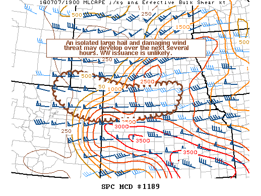
NOAA Storm Prediction Center Severe Thunderstorm Watch 350

Alomar Sharpe Thursday, July 7, 2016 // 3:35 pm

WW 350 SEVERE TSTM KY TN VA 072035Z – 080400Z URGENT – IMMEDIATE BROADCAST REQUESTED SEVERE THUNDERSTORM WATCH NUMBER 350 NWS STORM PREDICTION CENTER NORMAN OK 435 PM EDT THU JUL 7 2016 THE NWS STORM PREDICTION CENTER HAS ISSUED A * SEVERE THUNDERSTORM WATCH FOR PORTIONS OF SOUTHEASTERN KENTUCKY EASTERN TENNESSEE FAR SOUTHWEST VIRGINIA * EFFECTIVE THIS THURSDAY AFTERNOON… Read more →

Posted in Archive, Severe Weather Discussions | Tagged Severe Weather, Watches and Warnings, weather

NOAA Storm Prediction Center Severe Thunderstorm Watch 349

Alomar Sharpe Thursday, July 7, 2016 // 3:15 pm

WW 349 SEVERE TSTM NC SC CW 072015Z – 080300Z URGENT – IMMEDIATE BROADCAST REQUESTED SEVERE THUNDERSTORM WATCH NUMBER 349 NWS STORM PREDICTION CENTER NORMAN OK 415 PM EDT THU JUL 7 2016 THE NWS STORM PREDICTION CENTER HAS ISSUED A * SEVERE THUNDERSTORM WATCH FOR PORTIONS OF CENTRAL AND EASTERN NORTH CAROLINA NORTHERN AND EASTERN SOUTH CAROLINA COASTAL WATERS… Read more →

Posted in Archive, Severe Weather Discussions | Tagged Severe Weather, Watches and Warnings, weather
NOAA Storm Prediction Center Mesoscale Discussion 1191

NOAA Storm Prediction Center Mesoscale Discussion 1191

Alomar Sharpe Thursday, July 7, 2016 // 3:11 pm

MD 1191 CONCERNING SEVERE POTENTIAL…WATCH UNLIKELY FOR PORTIONS OF CNTRL/ERN ND AND NWRN MN MESOSCALE DISCUSSION 1191 NWS STORM PREDICTION CENTER NORMAN OK 0310 PM CDT THU JUL 07 2016 AREAS AFFECTED…PORTIONS OF CNTRL/ERN ND AND NWRN MN CONCERNING…SEVERE POTENTIAL…WATCH UNLIKELY VALID 072010Z – 072215Z PROBABILITY OF WATCH ISSUANCE…20 PERCENT SUMMARY…A BRIEF/ISOLATED TORNADO OR TWO ALONG WITH SMALL HAIL AND… Read more →

Posted in Archive, Severe Weather Discussions | Tagged Severe Weather, Watches and Warnings, weather
NOAA Storm Prediction Center Mesoscale Discussion 1190

NOAA Storm Prediction Center Mesoscale Discussion 1190

Alomar Sharpe Thursday, July 7, 2016 // 2:43 pm

MD 1190 CONCERNING SEVERE POTENTIAL…WATCH POSSIBLE FOR SERN VA…ERN NC…SC MESOSCALE DISCUSSION 1190 NWS STORM PREDICTION CENTER NORMAN OK 0242 PM CDT THU JUL 07 2016 AREAS AFFECTED…SERN VA…ERN NC…SC CONCERNING…SEVERE POTENTIAL…WATCH POSSIBLE VALID 071942Z – 072045Z PROBABILITY OF WATCH ISSUANCE…40 PERCENT SUMMARY…GUSTY WINDS WILL BE NOTED WITH A FEW STRONG STORMS THIS AFTERNOON. DISCUSSION…STRONG BOUNDARY-LAYER HEATING HAS CONTRIBUTED TO… Read more →

Posted in Archive, Severe Weather Discussions | Tagged Severe Weather, Watches and Warnings, weather
NOAA Storm Prediction Center Mesoscale Discussion 1189

NOAA Storm Prediction Center Mesoscale Discussion 1189

Alomar Sharpe Thursday, July 7, 2016 // 2:41 pm

MD 1189 CONCERNING SEVERE POTENTIAL…WATCH UNLIKELY FOR PORTIONS OF NERN CO…FAR SERN WY…SRN NEB…AND FAR NWRN KS MESOSCALE DISCUSSION 1189 NWS STORM PREDICTION CENTER NORMAN OK 0240 PM CDT THU JUL 07 2016 AREAS AFFECTED…PORTIONS OF NERN CO…FAR SERN WY…SRN NEB…AND FAR NWRN KS CONCERNING…SEVERE POTENTIAL…WATCH UNLIKELY VALID 071940Z – 072145Z PROBABILITY OF WATCH ISSUANCE…20 PERCENT SUMMARY…AN ISOLATED LARGE HAIL… Read more →

Posted in Archive, Severe Weather Discussions | Tagged Severe Weather, Watches and Warnings, weather
← Previous 1 … 277 278 279 … 2,028 Next →

Today’s Severe Weather Threat

SVR WX THREAT

Today’s Tornado Threat

SVR WX THREAT

Search The Site

Contributing Scientists

  • Alomar Sharpe
  • Amber Kulick
  • Branden Walker
  • Chris Vagasky
  • Colt Murray
  • Emily Riter
  • Kendall Junker
  • Matt Breland
  • Nick Lilja
  • NickelBlock Staff
  • Noah Gower

Wx Topics

2019 Atlantic Hurricane Season 2020 Atlantic hurricane Season Alabama Weather Amarillo weather Atlantic Hurricane Season Coronavirus COVID-19 COVID19 Earthquakes Flooding Geology Gulf Coast Weather hail hurricanes Louisiana Weather Mississippi Weather rain Severe Weather snow Texas Weather Thunderstorms Tornadoes Tropical Depressions Tropical Storms Tropical Weather tropics USGS Watches and Warnings weather Wind

What We Cover

  • Archive (10,136)
  • Climate (64)
  • Education (230)
  • Environment (8)
  • Forecasting (467)
  • Geology (210)
  • High Plains Weather (119)
  • Midwest Weather (35)
  • Northeast Weather (13)
  • Northwest Weather (5)
  • Not Weather (93)
  • Research (31)
  • River Flooding (23)
  • Severe Weather Discussions (8,640)
  • South Plains Weather (69)
  • Southeast Weather (312)
  • Space (19)
  • Storm Chasing (86)
  • Tropics (450)
  • Weather & Sports (4)
  • Weather & TV (37)
  • Weather History (8)
  • West Coast Weather (4)

Research

  • Conclusion: How multiple variables control TX/OK panhandle Spring severe weather
  • Findings: How multiple variables control TX/OK panhandle Spring severe weather
  • Methods: How multiple variables control TX/OK panhandle Spring severe weather
  • Introduction: How multiple variables control TX/OK panhandle Spring severe weather
  • Works Cited: How multiple variables control TX/OK panhandle Spring severe weather

Popular This Month

  • Remember that “Arctic Blast” people were posting about? Buckle up (6,957)
  • Another “Arctic Blast!” headed to the southeast says social media-rologists (2,420)
  • Arctic blast plunges Mississippi into ice age-like conditions colder than one of the moons of Jupiter (2,410)
  • More cold and snow has South Mississippi feeling like South Manitoba (1,888)
  • More wintry weather possible in South Mississippi next week (1,854)
  • Enough with the “Meteorologists get paid to be wrong” (1,617)
  • Afternoon Update: Snow possible for South Mississippi (960)
  • CIPS Analogs showing thunderstorms, possible severe weather, late next week for south Mississippi (949)
  • Freezing weather won’t kill all mosquitos (664)
  • Jan 16, south Mississippi morning snowfall update (541)
  • Instantly freeze water to make stalagmites (333)
  • Will it snow? A brief look at the steps to get it (318)

Primary Menu

  • About us
    • About us
    • How We Forecast
    • Archives
  • Our Services
    • Live Stream: Severe Weather Discussions
    • Go Storm Chasing
    • Pictures
  • Contact Us!
  • Jobs
  • Weather Safety
    • Weather Safety
    • Hurricane Preparedness Tips
    • Road Conditions
    • Current Conditions
    • South Mississippi river forecasts
    • Forecasting Presentation
  • Login

Secondary Menu

  • Severe Weather Outlook
    • Severe Outlook through Day 8
    • Severe Outlook By State
    • Today’s Severe Weather Threat
    • Today’s Tornado Threat
    • Today’s Severe Wind Threat
    • Today’s Severe Hail Threat
    • Excessive Rainfall Forecasts
  • Short Term Forecast
    • Current Radar & Satellite
    • Detailed National Forecast Discussion
    • National Surface Maps
    • National Temperatures
    • National Precipitation Chances
    • National Precipitation Estimates
    • National Snowfall Estimates
    • National Ice Estimates
    • National Convective Outlook
    • Public RAPTOR Map
    • Model Data Viewer
  • Tropics
  • 10 Day Trend
  • Seasonal Discussion

Copyright © 2026 NickelBlock Forecasting.

Powered by WordPress and Path. Back to Top

Google+
  • About us
  • Our Services
  • Contact Us!
  • Jobs
  • Weather Safety
  • Login