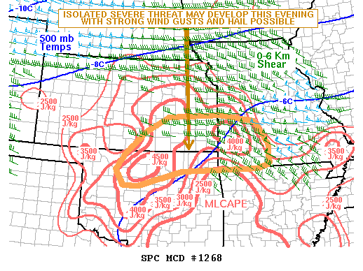
NOAA Storm Prediction Center Mesoscale Discussion 1268
MD 1268 CONCERNING SEVERE POTENTIAL…WATCH UNLIKELY FOR SE KS…SW MO AND FAR NE OK MESOSCALE DISCUSSION 1268 NWS STORM PREDICTION CENTER NORMAN OK 0657 PM CDT WED JUL 13 2016 AREAS AFFECTED…SE KS…SW MO AND FAR NE OK CONCERNING…SEVERE POTENTIAL…WATCH UNLIKELY VALID 132357Z – 140230Z PROBABILITY OF WATCH ISSUANCE…20 PERCENT SUMMARY…AN ISOLATED THREAT FOR STRONG WIND GUSTS AND HAIL MAY… Read more →