Two videos today! This is two sides of the same storm. One video is longer than the other. The first does have some audio (and some cursing) while the second one is mainly natural background sounds.
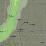
Latest 18z NAM computer weather model, which is our shorter medium range model, is now bringing in a chance for rain to the panhandles Sunday afternoon / night.
Not bad! And that’s not all! The latest Euro computer weather model is also on board with the NAM.
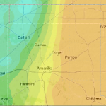
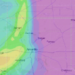
Now, in saying that, there’s not much rain out there. The total amount of rainfall that any one point will realize should stay below one-tenth of an inch of rain. Sadly, because we lack the available low-level moisture, rain won’t make it all the way to the ground in some spots. So virga will be the name of the game for you folks.
At the end of the day, the rain chances vary between 10- and 30-percent Sunday night. It’s looking like the best bet for rain will be west of a north-south line from Goodwell, Ok to Umbarger, Tx.
In the areas that do have the available low-level moisture, the right ingredients (CAPE Values over 100 J/kg & Bulk Shear above 20kts) are present for a few claps of thunder.
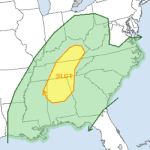
Severe thunderstorms threaten Kentucky, Tennessee, Alabama Monday
It looks like another round of severe thunderstorms are headed toward the souther Ohio River Valley, parts of Kentucky, Tennessee and Alabama. Scenario As a cold front associated with an area of low pressure swings through the Ohio, Tennessee, Kentucky area the threat for severe weather is possible. The bulk of the severe weather potential will be from Lexington, Kentucky… Read more →
Tornado Video of the Day: “HIGH DEFINITION HUGE MANITOBA TORNADO! June 23, 2007”
Reed Timmer at it again…
Tornado Video of the Day: EF-5 tornado: April 27, 2011 Tornado Outbreak in Mississippi and Alabama
Sometimes, Reed Timmer is about as good as it gets…

