Very eerie back-lit storm in Greeley, Nebraska.

Amarillo rides temperature roller coaster this week
Amarillo’s weather pattern is only slightly effected by the North Atlantic Oscillation. Generally speaking the more negative the NAO the easier it is for cold air to seep southward east of the Mississippi river. But it also tends to open the door for colder air across the high plains as well. And the NAO is looking quite negative right now…. Read more →
Amarillo’s Sunday night wind reminded me…
This is from the last time I got a chance to storm chase in Green Bay, Wisconsin. As you can see, I didn’t need to go far (my garage) to catch the winds! Later that afternoon/evening one storm rolled through and dropped a funnel just after sundown. Luckily it was on a storm moving over Lake Michigan and no one was injured.
But look at these winds!
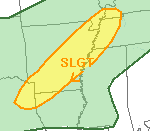
Texas, Arkansas face severe threat Sunday night
Earlier today it looked like Parts of Texas, Arkansas, Missouri, Tennessee and Kentucky would be battling isolated severe thunderstorms. Recently, the higher resolution computer weather models have leaned toward a far more isolated event. Current conditions show that colder air continues to erode away in the lower levels of the atmosphere. This will inhibit the production of severe storms in… Read more →
There are a few showers and some thunderstorms moving through the western tier of counties across the Texas panhandle this afternoon.

The area is lacking in low level moisture which means that light to moderate rain will be the most anyone will be able to squeeze out of the clouds. In fact, most places will end up getting nothing but virga (rain that evaporate before it hits the ground).
The main threats with any of these “storms” will be some rain, thunder and gusty to damaging winds.
Most will be moving at about 25 to 35mph from west to east.
Per the NWS:
Isolated gusty winds to 60 mph will be possible in mainly the western 3 tiers of panhandle counties late this afternoon. A broken line of showers and storms just moving into the panhandles from nm will encounter roughly 300-500 j/kg mlcape and 600-800 j/kg dcape and a modestly dry low lvl airmass. The main wind threat should end by around 8 pm.

