Primary Menu Search
  • About us
    • About us
    • How We Forecast
    • Archives
  • Our Services
    • Live Stream: Severe Weather Discussions
    • Go Storm Chasing
    • Pictures
  • Contact Us!
  • Jobs
  • Weather Safety
    • Weather Safety
    • Hurricane Preparedness Tips
    • Road Conditions
    • Current Conditions
    • South Mississippi river forecasts
    • Forecasting Presentation
  • Login

NickelBlock Forecasting

Funny name. Serious data.

Secondary Menu
  • Severe Weather Outlook
    • Severe Outlook through Day 8
    • Severe Outlook By State
    • Today’s Severe Weather Threat
    • Today’s Tornado Threat
    • Today’s Severe Wind Threat
    • Today’s Severe Hail Threat
    • Excessive Rainfall Forecasts
  • Short Term Forecast
    • Current Radar & Satellite
    • Detailed National Forecast Discussion
    • National Surface Maps
    • National Temperatures
    • National Precipitation Chances
    • National Precipitation Estimates
    • National Snowfall Estimates
    • National Ice Estimates
    • National Convective Outlook
    • Public RAPTOR Map
    • Model Data Viewer
  • Tropics
  • 10 Day Trend
  • Seasonal Discussion
You are here: Home ∼ Page 192
Storm Prediction Center Jul 23, 2016 Morning Outlook

Storm Prediction Center Jul 23, 2016 Morning Outlook

Alomar Sharpe Saturday, July 23, 2016 // 8:35 am

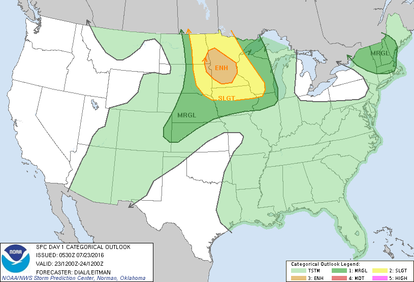
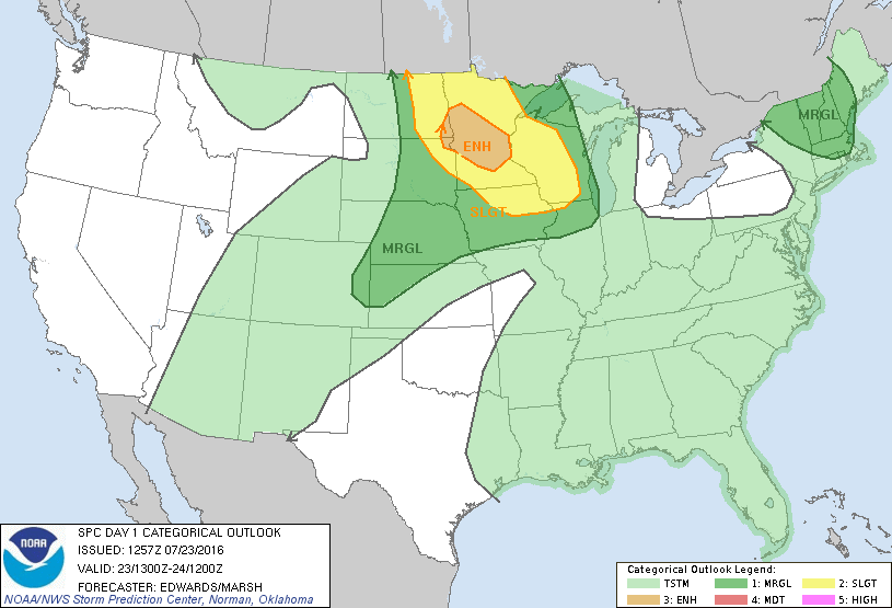
SPC 1300Z Day 1 Outlook DAY 1 CONVECTIVE OUTLOOK NWS STORM PREDICTION CENTER NORMAN OK 0757 AM CDT SAT JUL 23 2016 VALID 231300Z – 241200Z …THERE IS AN ENH RISK OF SEVERE THUNDERSTORMS PORTIONS ERN DAKOTAS AND MN… …THERE IS A SLGT RISK OF SEVERE THUNDERSTORMS SURROUNDING ENH RISK FROM WI TO ERN ND… …THERE IS A MRGL RISK… Read more →

Posted in Archive, Severe Weather Discussions | Tagged Severe Weather, weather
Storm Prediction Center Jul 23, 2016 Early Morning UTC Day 1 Convective Outlook

Storm Prediction Center Jul 23, 2016 Early Morning UTC Day 1 Convective Outlook

Alomar Sharpe Saturday, July 23, 2016 // 1:36 am

SPC 1200Z Day 1 Outlook DAY 1 CONVECTIVE OUTLOOK NWS STORM PREDICTION CENTER NORMAN OK 1230 AM CDT SAT JUL 23 2016 VALID 231200Z – 241200Z …THERE IS AN ENH RISK OF SEVERE THUNDERSTORMS FROM A PORTION OF THE ERN DAKOTAS INTO CNTRL AND SRN MN… …THERE IS A SLGT RISK OF SEVERE THUNDERSTORMS FROM A PORTION OF THE NRN… Read more →

Posted in Archive, Severe Weather Discussions | Tagged Severe Weather, weather
NOAA Storm Prediction Center Mesoscale Discussion 1366

NOAA Storm Prediction Center Mesoscale Discussion 1366

Alomar Sharpe Friday, July 22, 2016 // 9:39 pm

MD 1366 CONCERNING SEVERE THUNDERSTORM WATCH 410… FOR ERN MT…WRN ND…NWRN SD MESOSCALE DISCUSSION 1366 NWS STORM PREDICTION CENTER NORMAN OK 0938 PM CDT FRI JUL 22 2016 AREAS AFFECTED…ERN MT…WRN ND…NWRN SD CONCERNING…SEVERE THUNDERSTORM WATCH 410… VALID 230238Z – 230445Z THE SEVERE WEATHER THREAT FOR SEVERE THUNDERSTORM WATCH 410 CONTINUES. SUMMARY…THUNDERSTORMS ARE EXPECTED TO FOCUS ACROSS NERN MT INTO… Read more →

Posted in Archive, Severe Weather Discussions | Tagged Severe Weather, Watches and Warnings, weather
NOAA Storm Prediction Center Mesoscale Discussion 1365

NOAA Storm Prediction Center Mesoscale Discussion 1365

Alomar Sharpe Friday, July 22, 2016 // 9:02 pm

MD 1365 CONCERNING SEVERE POTENTIAL…WATCH POSSIBLE FOR SWRN NEB…NERN CO…NWRN KS MESOSCALE DISCUSSION 1365 NWS STORM PREDICTION CENTER NORMAN OK 0901 PM CDT FRI JUL 22 2016 AREAS AFFECTED…SWRN NEB…NERN CO…NWRN KS CONCERNING…SEVERE POTENTIAL…WATCH POSSIBLE VALID 230201Z – 230300Z PROBABILITY OF WATCH ISSUANCE…40 PERCENT SUMMARY…THUNDERSTORM CLUSTERS WILL PROPAGATE SEWD ACROSS THE CENTRAL HIGH PLAINS. LARGE HAIL AND DAMAGING WINDS MAY… Read more →

Posted in Archive, Severe Weather Discussions | Tagged Severe Weather, Watches and Warnings, weather
Storm Prediction Center Jul 23, 2016 UTC Evening Outlook

Storm Prediction Center Jul 23, 2016 UTC Evening Outlook

Alomar Sharpe Friday, July 22, 2016 // 8:35 pm

SPC 0100Z Day 1 Outlook DAY 1 CONVECTIVE OUTLOOK NWS STORM PREDICTION CENTER NORMAN OK 0800 PM CDT FRI JUL 22 2016 VALID 230100Z – 231200Z …THERE IS A SLGT RISK OF SEVERE THUNDERSTORMS FROM ERN MT THROUGH ND AND NRN SD… …THERE IS A MRGL RISK OF SEVERE THUNDERSTORMS FROM THE NRN AND CNTRL PLAINS THROUGH THE UPPER MS… Read more →

Posted in Archive, Severe Weather Discussions | Tagged Severe Weather, weather
← Previous 1 … 191 192 193 … 2,028 Next →

Today’s Severe Weather Threat

SVR WX THREAT

Today’s Tornado Threat

SVR WX THREAT

Search The Site

Contributing Scientists

  • Alomar Sharpe
  • Amber Kulick
  • Branden Walker
  • Chris Vagasky
  • Colt Murray
  • Emily Riter
  • Kendall Junker
  • Matt Breland
  • Nick Lilja
  • NickelBlock Staff
  • Noah Gower

Wx Topics

2019 Atlantic Hurricane Season 2020 Atlantic hurricane Season Alabama Weather Amarillo weather Atlantic Hurricane Season Coronavirus COVID-19 COVID19 Earthquakes Flooding Geology Gulf Coast Weather hail hurricanes Louisiana Weather Mississippi Weather rain Severe Weather snow Texas Weather Thunderstorms Tornadoes Tropical Depressions Tropical Storms Tropical Weather tropics USGS Watches and Warnings weather Wind

What We Cover

  • Archive (10,136)
  • Climate (64)
  • Education (230)
  • Environment (8)
  • Forecasting (467)
  • Geology (210)
  • High Plains Weather (119)
  • Midwest Weather (35)
  • Northeast Weather (13)
  • Northwest Weather (5)
  • Not Weather (93)
  • Research (31)
  • River Flooding (23)
  • Severe Weather Discussions (8,640)
  • South Plains Weather (69)
  • Southeast Weather (312)
  • Space (19)
  • Storm Chasing (86)
  • Tropics (450)
  • Weather & Sports (4)
  • Weather & TV (37)
  • Weather History (8)
  • West Coast Weather (4)

Research

  • Conclusion: How multiple variables control TX/OK panhandle Spring severe weather
  • Findings: How multiple variables control TX/OK panhandle Spring severe weather
  • Methods: How multiple variables control TX/OK panhandle Spring severe weather
  • Introduction: How multiple variables control TX/OK panhandle Spring severe weather
  • Works Cited: How multiple variables control TX/OK panhandle Spring severe weather

Popular This Month

  • Remember that “Arctic Blast” people were posting about? Buckle up (6,957)
  • Another “Arctic Blast!” headed to the southeast says social media-rologists (2,420)
  • Arctic blast plunges Mississippi into ice age-like conditions colder than one of the moons of Jupiter (2,410)
  • More cold and snow has South Mississippi feeling like South Manitoba (1,888)
  • More wintry weather possible in South Mississippi next week (1,854)
  • Enough with the “Meteorologists get paid to be wrong” (1,617)
  • Afternoon Update: Snow possible for South Mississippi (960)
  • CIPS Analogs showing thunderstorms, possible severe weather, late next week for south Mississippi (949)
  • Freezing weather won’t kill all mosquitos (664)
  • Jan 16, south Mississippi morning snowfall update (541)
  • Instantly freeze water to make stalagmites (333)
  • Will it snow? A brief look at the steps to get it (318)

Primary Menu

  • About us
    • About us
    • How We Forecast
    • Archives
  • Our Services
    • Live Stream: Severe Weather Discussions
    • Go Storm Chasing
    • Pictures
  • Contact Us!
  • Jobs
  • Weather Safety
    • Weather Safety
    • Hurricane Preparedness Tips
    • Road Conditions
    • Current Conditions
    • South Mississippi river forecasts
    • Forecasting Presentation
  • Login

Secondary Menu

  • Severe Weather Outlook
    • Severe Outlook through Day 8
    • Severe Outlook By State
    • Today’s Severe Weather Threat
    • Today’s Tornado Threat
    • Today’s Severe Wind Threat
    • Today’s Severe Hail Threat
    • Excessive Rainfall Forecasts
  • Short Term Forecast
    • Current Radar & Satellite
    • Detailed National Forecast Discussion
    • National Surface Maps
    • National Temperatures
    • National Precipitation Chances
    • National Precipitation Estimates
    • National Snowfall Estimates
    • National Ice Estimates
    • National Convective Outlook
    • Public RAPTOR Map
    • Model Data Viewer
  • Tropics
  • 10 Day Trend
  • Seasonal Discussion

Copyright © 2026 NickelBlock Forecasting.

Powered by WordPress and Path. Back to Top

Google+
  • About us
  • Our Services
  • Contact Us!
  • Jobs
  • Weather Safety
  • Login