Primary Menu Search
  • About us
    • About us
    • How We Forecast
    • Archives
  • Our Services
    • Live Stream: Severe Weather Discussions
    • Go Storm Chasing
    • Pictures
  • Contact Us!
  • Jobs
  • Weather Safety
    • Weather Safety
    • Hurricane Preparedness Tips
    • Road Conditions
    • Current Conditions
    • South Mississippi river forecasts
    • Forecasting Presentation
  • Login

NickelBlock Forecasting

Funny name. Serious data.

Secondary Menu
  • Severe Weather Outlook
    • Severe Outlook through Day 8
    • Severe Outlook By State
    • Today’s Severe Weather Threat
    • Today’s Tornado Threat
    • Today’s Severe Wind Threat
    • Today’s Severe Hail Threat
    • Excessive Rainfall Forecasts
  • Short Term Forecast
    • Current Radar & Satellite
    • Detailed National Forecast Discussion
    • National Surface Maps
    • National Temperatures
    • National Precipitation Chances
    • National Precipitation Estimates
    • National Snowfall Estimates
    • National Ice Estimates
    • National Convective Outlook
    • Public RAPTOR Map
    • Model Data Viewer
  • Tropics
  • 10 Day Trend
  • Seasonal Discussion
You are here: Home ∼ Page 182

NOAA Storm Prediction Center Severe Thunderstorm Watch 415

Alomar Sharpe Monday, July 25, 2016 // 11:45 am

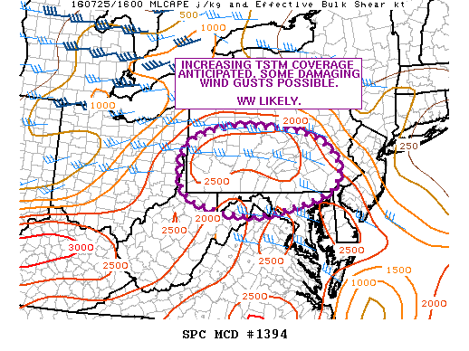
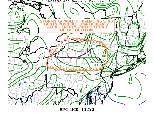
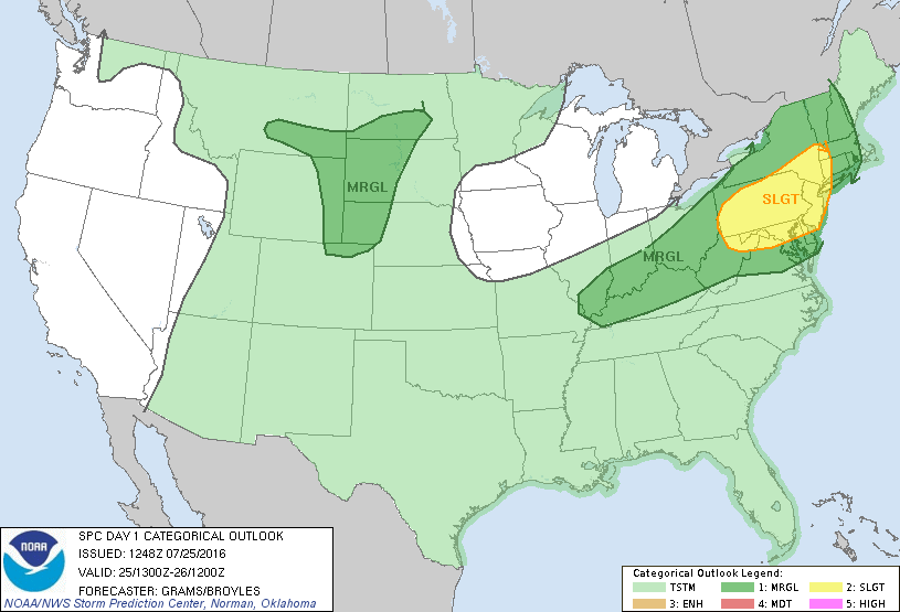
WW 415 SEVERE TSTM CT NJ NY PA CW 251645Z – 260000Z URGENT – IMMEDIATE BROADCAST REQUESTED SEVERE THUNDERSTORM WATCH NUMBER 415 NWS STORM PREDICTION CENTER NORMAN OK 1245 PM EDT MON JUL 25 2016 THE NWS STORM PREDICTION CENTER HAS ISSUED A * SEVERE THUNDERSTORM WATCH FOR PORTIONS OF SOUTHWEST CONNECTICUT NEW JERSEY SOUTHERN NEW YORK PENNSYLVANIA COASTAL WATERS… Read more →

Posted in Archive, Severe Weather Discussions | Tagged Severe Weather, Watches and Warnings, weather
NOAA Storm Prediction Center Mesoscale Discussion 1394

NOAA Storm Prediction Center Mesoscale Discussion 1394

Alomar Sharpe Monday, July 25, 2016 // 11:42 am

MD 1394 CONCERNING SEVERE POTENTIAL…WATCH LIKELY FOR CNTRL/SRN PA…MD PANHANDLE…ERN PANHANDLE OF WV MESOSCALE DISCUSSION 1394 NWS STORM PREDICTION CENTER NORMAN OK 1141 AM CDT MON JUL 25 2016 AREAS AFFECTED…CNTRL/SRN PA…MD PANHANDLE…ERN PANHANDLE OF WV CONCERNING…SEVERE POTENTIAL…WATCH LIKELY VALID 251641Z – 251745Z PROBABILITY OF WATCH ISSUANCE…95 PERCENT SUMMARY…INCREASING TSTM COVERAGE IS ANTICIPATED DURING THE NEXT FEW HOURS WITH SOME… Read more →

Posted in Archive, Severe Weather Discussions | Tagged Severe Weather, Watches and Warnings, weather
NOAA Storm Prediction Center Mesoscale Discussion 1393

NOAA Storm Prediction Center Mesoscale Discussion 1393

Alomar Sharpe Monday, July 25, 2016 // 9:52 am

MD 1393 CONCERNING SEVERE POTENTIAL…WATCH POSSIBLE FOR WRN/CNTRL NY…NRN PA MESOSCALE DISCUSSION 1393 NWS STORM PREDICTION CENTER NORMAN OK 0951 AM CDT MON JUL 25 2016 AREAS AFFECTED…WRN/CNTRL NY…NRN PA CONCERNING…SEVERE POTENTIAL…WATCH POSSIBLE VALID 251451Z – 251645Z PROBABILITY OF WATCH ISSUANCE…40 PERCENT SUMMARY…ONGOING CLUSTER OF STORMS NEAR THE FINGER LAKES IS EXPECTED TO GRADUALLY WEAKEN WHILE ADDITIONAL TSTM ACTIVITY MAY… Read more →

Posted in Archive, Severe Weather Discussions | Tagged Severe Weather, Watches and Warnings, weather
Storm Prediction Center Jul 25, 2016 Morning Outlook

Storm Prediction Center Jul 25, 2016 Morning Outlook

Alomar Sharpe Monday, July 25, 2016 // 8:35 am

SPC 1300Z Day 1 Outlook DAY 1 CONVECTIVE OUTLOOK NWS STORM PREDICTION CENTER NORMAN OK 0748 AM CDT MON JUL 25 2016 VALID 251300Z – 261200Z …THERE IS A SLGT RISK OF SEVERE THUNDERSTORMS NORTHEAST… …THERE IS A MRGL RISK OF SEVERE THUNDERSTORMS WRN NEW ENGLAND TO OH VALLEY… …THERE IS A MRGL RISK OF SEVERE THUNDERSTORMS SRN ND/SERN MT… Read more →

Posted in Archive, Severe Weather Discussions | Tagged Severe Weather, weather
← Previous 1 … 181 182 183 … 2,028 Next →

Today’s Severe Weather Threat

SVR WX THREAT

Today’s Tornado Threat

SVR WX THREAT

Search The Site

Contributing Scientists

  • Alomar Sharpe
  • Amber Kulick
  • Branden Walker
  • Chris Vagasky
  • Colt Murray
  • Emily Riter
  • Kendall Junker
  • Matt Breland
  • Nick Lilja
  • NickelBlock Staff
  • Noah Gower

Wx Topics

2019 Atlantic Hurricane Season 2020 Atlantic hurricane Season Alabama Weather Amarillo weather Atlantic Hurricane Season Coronavirus COVID-19 COVID19 Earthquakes Flooding Geology Gulf Coast Weather hail hurricanes Louisiana Weather Mississippi Weather rain Severe Weather snow Texas Weather Thunderstorms Tornadoes Tropical Depressions Tropical Storms Tropical Weather tropics USGS Watches and Warnings weather Wind

What We Cover

  • Archive (10,136)
  • Climate (64)
  • Education (230)
  • Environment (8)
  • Forecasting (467)
  • Geology (210)
  • High Plains Weather (119)
  • Midwest Weather (35)
  • Northeast Weather (13)
  • Northwest Weather (5)
  • Not Weather (93)
  • Research (31)
  • River Flooding (23)
  • Severe Weather Discussions (8,640)
  • South Plains Weather (69)
  • Southeast Weather (312)
  • Space (19)
  • Storm Chasing (86)
  • Tropics (450)
  • Weather & Sports (4)
  • Weather & TV (37)
  • Weather History (8)
  • West Coast Weather (4)

Research

  • Conclusion: How multiple variables control TX/OK panhandle Spring severe weather
  • Findings: How multiple variables control TX/OK panhandle Spring severe weather
  • Methods: How multiple variables control TX/OK panhandle Spring severe weather
  • Introduction: How multiple variables control TX/OK panhandle Spring severe weather
  • Works Cited: How multiple variables control TX/OK panhandle Spring severe weather

Popular This Month

  • Remember that “Arctic Blast” people were posting about? Buckle up (6,957)
  • Another “Arctic Blast!” headed to the southeast says social media-rologists (2,420)
  • Arctic blast plunges Mississippi into ice age-like conditions colder than one of the moons of Jupiter (2,410)
  • More cold and snow has South Mississippi feeling like South Manitoba (1,888)
  • More wintry weather possible in South Mississippi next week (1,854)
  • Enough with the “Meteorologists get paid to be wrong” (1,617)
  • Afternoon Update: Snow possible for South Mississippi (960)
  • CIPS Analogs showing thunderstorms, possible severe weather, late next week for south Mississippi (949)
  • Freezing weather won’t kill all mosquitos (664)
  • Jan 16, south Mississippi morning snowfall update (541)
  • Instantly freeze water to make stalagmites (333)
  • Will it snow? A brief look at the steps to get it (318)

Primary Menu

  • About us
    • About us
    • How We Forecast
    • Archives
  • Our Services
    • Live Stream: Severe Weather Discussions
    • Go Storm Chasing
    • Pictures
  • Contact Us!
  • Jobs
  • Weather Safety
    • Weather Safety
    • Hurricane Preparedness Tips
    • Road Conditions
    • Current Conditions
    • South Mississippi river forecasts
    • Forecasting Presentation
  • Login

Secondary Menu

  • Severe Weather Outlook
    • Severe Outlook through Day 8
    • Severe Outlook By State
    • Today’s Severe Weather Threat
    • Today’s Tornado Threat
    • Today’s Severe Wind Threat
    • Today’s Severe Hail Threat
    • Excessive Rainfall Forecasts
  • Short Term Forecast
    • Current Radar & Satellite
    • Detailed National Forecast Discussion
    • National Surface Maps
    • National Temperatures
    • National Precipitation Chances
    • National Precipitation Estimates
    • National Snowfall Estimates
    • National Ice Estimates
    • National Convective Outlook
    • Public RAPTOR Map
    • Model Data Viewer
  • Tropics
  • 10 Day Trend
  • Seasonal Discussion

Copyright © 2026 NickelBlock Forecasting.

Powered by WordPress and Path. Back to Top

Google+
  • About us
  • Our Services
  • Contact Us!
  • Jobs
  • Weather Safety
  • Login