10PM UPDATE: Hurricane Michael continues north, strengthens
BULLETIN Hurricane Michael Advisory Number 10 NWS National Hurricane Center Miami FL AL142018 1000 PM CDT Mon Oct 08 2018 …MICHAEL CONTINUES TO STRENGTHEN… …STORM SURGE AND HURRICANE WARNINGS IN EFFECT FOR THE NORTHEASTERN GULF COAST… SUMMARY OF 1000 PM CDT…0300 UTC…INFORMATION ———————————————– LOCATION…23.2N 85.3W ABOUT 485 MI…780 KM S OF PANAMA CITY FLORIDA ABOUT 450 MI…725 KM S OF… Read more →
8PM UPDATE: Tropical Storm Michael continues to strengthen, move north
Tropical Storm Michael is now forecast to be a Category Two hurricane as is moves ashore somewhere between Pensacola, Florida and Cedar Key, Florida Wednesday around midday.
Impacts will be felt outside of the Cone of Uncertainty. Especially on the east side of the storm. If you live near or to the east of the Cone, please double check your Hurricane Preparedness Kit.
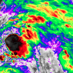
Down and Dirty details: Quick update on Invest91L development, possible threat to Gulf coast
*** 400PM UPDATE FROM NHC*** BULLETIN Potential Tropical Cyclone Fourteen Advisory Number 1 NWS National Hurricane Center Miami FL AL142018 400 PM CDT Sat Oct 06 2018 …DISTURBANCE GETTING BETTER ORGANIZED OVER THE NORTHWESTERN CARIBBEAN SEA… …WARNINGS AND WATCHES ISSUED FOR PORTIONS OF WESTERN CUBA AND THE YUCATAN PENINSULA.. SUMMARY OF 400 PM CDT…2100 UTC…INFORMATION ———————————————- LOCATION…18.0N 86.6W ABOUT 175… Read more →
What is “MRMS” and how does it help meteorologists?
Radar is a great tool for meteorologists during any weather event, but especially during severe weather. The MRMS toolkit is one that helps radar meteorologists during severe weather figure out what is happening in the storm by using multiple radar site and computer model data. Officially speaking, MRMS is… The Multi-Radar Multi-Sensor (MRMS) project utilizes an automated system that rapidly… Read more →

