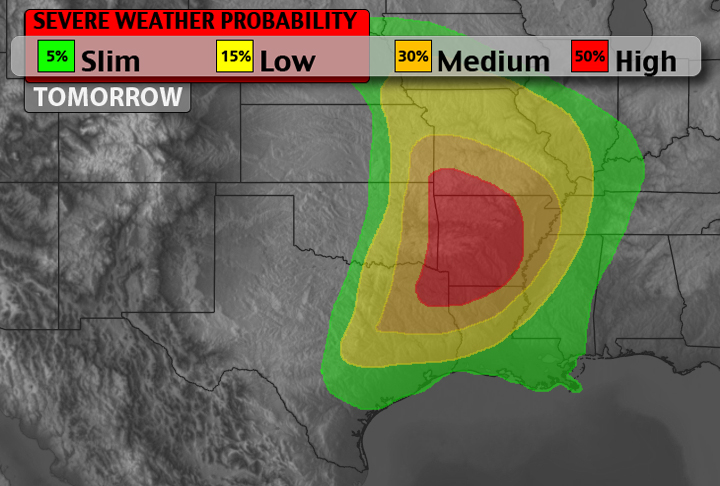
Tomorrow will be an active severe weather day across parts of the South Plains and Southeast.

Tomorrow will be an active severe weather day across parts of the South Plains and Southeast.

Good morning / afternoon everyone. After taking another look at the latest model runs I’ve crafted a different area for where severe weather will be likely today. Notice that the threat shifted a little farther east and has been expanded. Also the tornado threat has been expanded and shifted east. Right now, the threat for EF-2 or greater tornadoes isn’t… Read more →
My lights went out as I started recording! I was in the dark, but don’t YOU be caught in the dark during today’s severe weather…
The SPC is discussing the threat for severe weather this afternoon. The possibility of large hail, damaging winds and isolated tornadoes will be realized across parts of Arkansas, Missouri and other sections of the southern plains, southeast and Midwest.
Take a look:SPC Severe Weather Breakdown
As meteorologists look at today’s setup it is looking promising that severe weather will develop.
The main bulk of the severe action will be in parts of Missouri, Arkansas, western Tennessee and Kentucky and northern Louisiana.
There is also the threat for severe weather in the southernmost sections of Illinois, and northernmost sections of Mississippi.
The biggest threats for today are wind and hail. Both on the strong/large side of the spectrum.
Looking at the latest 6z RAP here are some of the severe weather indicators we’re watching:
CAPE: >2,000 J/kg
Helicity (0-1km): 75 – 200
EHI (0-3km): 1 – 3.5
LCL Heights: 800m – 1500m
Lifted Index: -3 – -10
All of these point to the potential for damaging winds, large hail and possible tornadoes.