I decided to have some fun today while waiting for things to develop in northwest Texas…
Video: Needle Tornado & Amazing Supercell! SW OK, NW TX 4/20/2014
A great catalogue of shots from the one storm that produced a tornado on Easter Sunday of 2014 across the low rolling plains of Texas.
We were watching this area in the morning on Sunday and highlighted this area as having the highest potential to produce a short-lived quick spin-up of a tornado. We’re glad that it verified. And even happier that it verified without causing damage – that we know of, yet.
This video from Jason Cooley’s youtube channel:
Tomorrow’s Severe Weather Potential – 4/13/14
I don’t think I made is clear enough in the video: This forecast is for tomorrow and not today.
Severe Weather Breakdown – 4/12/14
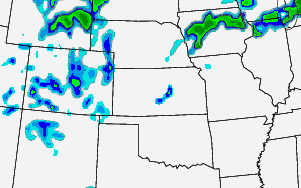
Update (4/12/14 2:20): It looks like the threat for severe weather is shifting north as we move through the day.
Here is the latest look at the RAP for the composite reflectivity at 8pm.

Notice most of the convection is north across parts of Iowa.
There is still the threat for severe weather despite the smaller coverage area. Also, there is still the threat for a renegade storm across parts of Kansas.
2013 El Reno Tornado
Here is some video I shot on the tail end of the El Reno storm chase. I stayed at a very safe distance – as you can tell from the video – and only caught a couple of glimpses of the monster tornado.
After listening to radio reports and storm spotter chatter, I decided to err on the side of safety. So after a quick trip up the road to get a quick peek, I turned tail and headed south to shoot some video.

