Primary Menu Search
  • About us
    • About us
    • How We Forecast
    • Archives
  • Our Services
    • Live Stream: Severe Weather Discussions
    • Go Storm Chasing
    • Pictures
  • Contact Us!
  • Jobs
  • Weather Safety
    • Weather Safety
    • Hurricane Preparedness Tips
    • Road Conditions
    • Current Conditions
    • South Mississippi river forecasts
    • Forecasting Presentation
  • Login

NickelBlock Forecasting

Funny name. Serious data.

Secondary Menu
  • Severe Weather Outlook
    • Severe Outlook through Day 8
    • Severe Outlook By State
    • Today’s Severe Weather Threat
    • Today’s Tornado Threat
    • Today’s Severe Wind Threat
    • Today’s Severe Hail Threat
    • Excessive Rainfall Forecasts
  • Short Term Forecast
    • Current Radar & Satellite
    • Detailed National Forecast Discussion
    • National Surface Maps
    • National Temperatures
    • National Precipitation Chances
    • National Precipitation Estimates
    • National Snowfall Estimates
    • National Ice Estimates
    • National Convective Outlook
    • Public RAPTOR Map
    • Model Data Viewer
  • Tropics
  • 10 Day Trend
  • Seasonal Discussion
You are here: Home ∼ Page 483

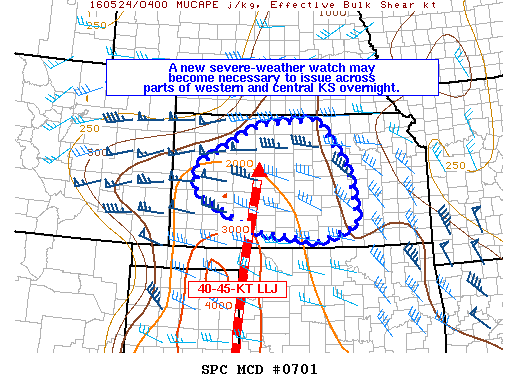
NOAA Storm Prediction Center Severe Thunderstorm Watch 202

Alomar Sharpe Tuesday, May 24, 2016 // 12:10 am

WW 202 SEVERE TSTM KS 240510Z – 241200Z URGENT – IMMEDIATE BROADCAST REQUESTED SEVERE THUNDERSTORM WATCH NUMBER 202 NWS STORM PREDICTION CENTER NORMAN OK 1210 AM CDT TUE MAY 24 2016 THE NWS STORM PREDICTION CENTER HAS ISSUED A * SEVERE THUNDERSTORM WATCH FOR PORTIONS OF CENTRAL AND NORTHERN KANSAS * EFFECTIVE THIS TUESDAY MORNING FROM 1210 AM UNTIL 700… Read more →

Posted in Archive, Severe Weather Discussions | Tagged Severe Weather, Watches and Warnings, weather
NOAA Storm Prediction Center Mesoscale Discussion 701

NOAA Storm Prediction Center Mesoscale Discussion 701

Alomar Sharpe Monday, May 23, 2016 // 11:52 pm

MD 0701 CONCERNING SEVERE POTENTIAL…WATCH POSSIBLE FOR PARTS OF WESTERN AND CENTRAL KS MESOSCALE DISCUSSION 0701 NWS STORM PREDICTION CENTER NORMAN OK 1151 PM CDT MON MAY 23 2016 AREAS AFFECTED…PARTS OF WESTERN AND CENTRAL KS CONCERNING…SEVERE POTENTIAL…WATCH POSSIBLE VALID 240451Z – 240645Z PROBABILITY OF WATCH ISSUANCE…60 PERCENT SUMMARY…TSTMS COVERAGE IS EXPECTED TO INCREASE OVERNIGHT ACROSS PARTS OF WESTERN AND… Read more →

Posted in Archive, Severe Weather Discussions | Tagged Severe Weather, Watches and Warnings, weather

NOAA Storm Prediction Center Severe Thunderstorm Watch 201

Alomar Sharpe Monday, May 23, 2016 // 11:45 pm

WW 201 SEVERE TSTM OK TX 240445Z – 241000Z URGENT – IMMEDIATE BROADCAST REQUESTED SEVERE THUNDERSTORM WATCH NUMBER 201 NWS STORM PREDICTION CENTER NORMAN OK 1145 PM CDT MON MAY 23 2016 THE NWS STORM PREDICTION CENTER HAS ISSUED A * SEVERE THUNDERSTORM WATCH FOR PORTIONS OF WESTERN OKLAHOMA EASTERN PANHANDLE OF TEXAS * EFFECTIVE THIS MONDAY NIGHT AND TUESDAY… Read more →

Posted in Archive, Severe Weather Discussions | Tagged Severe Weather, Watches and Warnings, weather
NOAA Storm Prediction Center Mesoscale Discussion 700

NOAA Storm Prediction Center Mesoscale Discussion 700

Alomar Sharpe Monday, May 23, 2016 // 11:23 pm

MD 0700 CONCERNING SEVERE POTENTIAL…WATCH POSSIBLE FOR SOUTHEAST TX PANHANDLE/WESTERN NORTH TX/SOUTHWEST OK AND NORTHWEST OK/SOUTH-CENTRAL KS MESOSCALE DISCUSSION 0700 NWS STORM PREDICTION CENTER NORMAN OK 1122 PM CDT MON MAY 23 2016 AREAS AFFECTED…SOUTHEAST TX PANHANDLE/WESTERN NORTH TX/SOUTHWEST OK AND NORTHWEST OK/SOUTH-CENTRAL KS CONCERNING…SEVERE POTENTIAL…WATCH POSSIBLE VALID 240422Z – 240545Z PROBABILITY OF WATCH ISSUANCE…40 PERCENT SUMMARY…NEW TSTMS SHOULD CONTINUE… Read more →

Posted in Archive, Severe Weather Discussions | Tagged Severe Weather, Watches and Warnings, weather
NOAA Storm Prediction Center Mesoscale Discussion 699

NOAA Storm Prediction Center Mesoscale Discussion 699

Alomar Sharpe Monday, May 23, 2016 // 8:59 pm

MD 0699 CONCERNING TORNADO WATCH 199…200… FOR ERN TX PANHANDLE…NWRN TX…WRN OK MESOSCALE DISCUSSION 0699 NWS STORM PREDICTION CENTER NORMAN OK 0858 PM CDT MON MAY 23 2016 AREAS AFFECTED…ERN TX PANHANDLE…NWRN TX…WRN OK CONCERNING…TORNADO WATCH 199…200… VALID 240158Z – 240330Z THE SEVERE WEATHER THREAT FOR TORNADO WATCH 199…200…CONTINUES. SUMMARY…CONVECTIVE TRENDS OVERALL ARE DECREASING…ALTHOUGH ISOLATED INSTANCES OF LARGE HAIL…STRONG WIND… Read more →

Posted in Archive, Severe Weather Discussions | Tagged Severe Weather, Watches and Warnings, weather
← Previous 1 … 482 483 484 … 2,028 Next →

Today’s Severe Weather Threat

SVR WX THREAT

Today’s Tornado Threat

SVR WX THREAT

Search The Site

Contributing Scientists

  • Alomar Sharpe
  • Amber Kulick
  • Branden Walker
  • Chris Vagasky
  • Colt Murray
  • Emily Riter
  • Kendall Junker
  • Matt Breland
  • Nick Lilja
  • NickelBlock Staff
  • Noah Gower

Wx Topics

2019 Atlantic Hurricane Season 2020 Atlantic hurricane Season Alabama Weather Amarillo weather Atlantic Hurricane Season Coronavirus COVID-19 COVID19 Earthquakes Flooding Geology Gulf Coast Weather hail hurricanes Louisiana Weather Mississippi Weather rain Severe Weather snow Texas Weather Thunderstorms Tornadoes Tropical Depressions Tropical Storms Tropical Weather tropics USGS Watches and Warnings weather Wind

What We Cover

  • Archive (10,136)
  • Climate (64)
  • Education (230)
  • Environment (8)
  • Forecasting (467)
  • Geology (210)
  • High Plains Weather (119)
  • Midwest Weather (35)
  • Northeast Weather (13)
  • Northwest Weather (5)
  • Not Weather (93)
  • Research (31)
  • River Flooding (23)
  • Severe Weather Discussions (8,640)
  • South Plains Weather (69)
  • Southeast Weather (312)
  • Space (19)
  • Storm Chasing (86)
  • Tropics (450)
  • Weather & Sports (4)
  • Weather & TV (37)
  • Weather History (8)
  • West Coast Weather (4)

Research

  • Conclusion: How multiple variables control TX/OK panhandle Spring severe weather
  • Findings: How multiple variables control TX/OK panhandle Spring severe weather
  • Methods: How multiple variables control TX/OK panhandle Spring severe weather
  • Introduction: How multiple variables control TX/OK panhandle Spring severe weather
  • Works Cited: How multiple variables control TX/OK panhandle Spring severe weather

Popular This Month

  • Remember that “Arctic Blast” people were posting about? Buckle up (6,957)
  • Another “Arctic Blast!” headed to the southeast says social media-rologists (2,420)
  • Arctic blast plunges Mississippi into ice age-like conditions colder than one of the moons of Jupiter (2,410)
  • More cold and snow has South Mississippi feeling like South Manitoba (1,888)
  • More wintry weather possible in South Mississippi next week (1,854)
  • Enough with the “Meteorologists get paid to be wrong” (1,617)
  • Afternoon Update: Snow possible for South Mississippi (960)
  • CIPS Analogs showing thunderstorms, possible severe weather, late next week for south Mississippi (949)
  • Freezing weather won’t kill all mosquitos (664)
  • Jan 16, south Mississippi morning snowfall update (541)
  • Instantly freeze water to make stalagmites (333)
  • Will it snow? A brief look at the steps to get it (318)

Primary Menu

  • About us
    • About us
    • How We Forecast
    • Archives
  • Our Services
    • Live Stream: Severe Weather Discussions
    • Go Storm Chasing
    • Pictures
  • Contact Us!
  • Jobs
  • Weather Safety
    • Weather Safety
    • Hurricane Preparedness Tips
    • Road Conditions
    • Current Conditions
    • South Mississippi river forecasts
    • Forecasting Presentation
  • Login

Secondary Menu

  • Severe Weather Outlook
    • Severe Outlook through Day 8
    • Severe Outlook By State
    • Today’s Severe Weather Threat
    • Today’s Tornado Threat
    • Today’s Severe Wind Threat
    • Today’s Severe Hail Threat
    • Excessive Rainfall Forecasts
  • Short Term Forecast
    • Current Radar & Satellite
    • Detailed National Forecast Discussion
    • National Surface Maps
    • National Temperatures
    • National Precipitation Chances
    • National Precipitation Estimates
    • National Snowfall Estimates
    • National Ice Estimates
    • National Convective Outlook
    • Public RAPTOR Map
    • Model Data Viewer
  • Tropics
  • 10 Day Trend
  • Seasonal Discussion

Copyright © 2026 NickelBlock Forecasting.

Powered by WordPress and Path. Back to Top

Google+
  • About us
  • Our Services
  • Contact Us!
  • Jobs
  • Weather Safety
  • Login