Primary Menu Search
  • About us
    • About us
    • How We Forecast
    • Archives
  • Our Services
    • Live Stream: Severe Weather Discussions
    • Go Storm Chasing
    • Pictures
  • Contact Us!
  • Jobs
  • Weather Safety
    • Weather Safety
    • Hurricane Preparedness Tips
    • Road Conditions
    • Current Conditions
    • South Mississippi river forecasts
    • Forecasting Presentation
  • Login

NickelBlock Forecasting

Funny name. Serious data.

Secondary Menu
  • Severe Weather Outlook
    • Severe Outlook through Day 8
    • Severe Outlook By State
    • Today’s Severe Weather Threat
    • Today’s Tornado Threat
    • Today’s Severe Wind Threat
    • Today’s Severe Hail Threat
    • Excessive Rainfall Forecasts
  • Short Term Forecast
    • Current Radar & Satellite
    • Detailed National Forecast Discussion
    • National Surface Maps
    • National Temperatures
    • National Precipitation Chances
    • National Precipitation Estimates
    • National Snowfall Estimates
    • National Ice Estimates
    • National Convective Outlook
    • Public RAPTOR Map
    • Model Data Viewer
  • Tropics
  • 10 Day Trend
  • Seasonal Discussion
You are here: Home ∼ Page 455

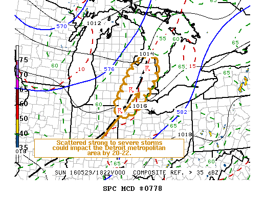
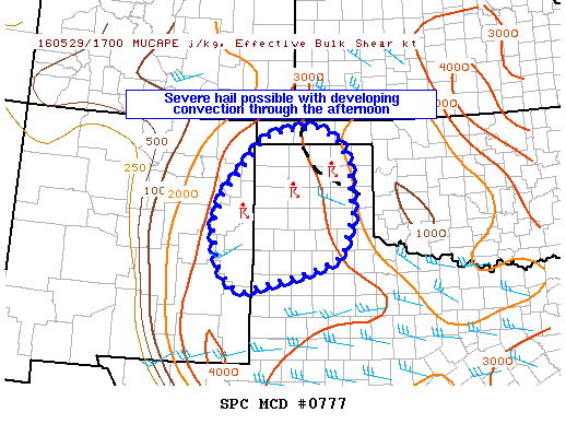
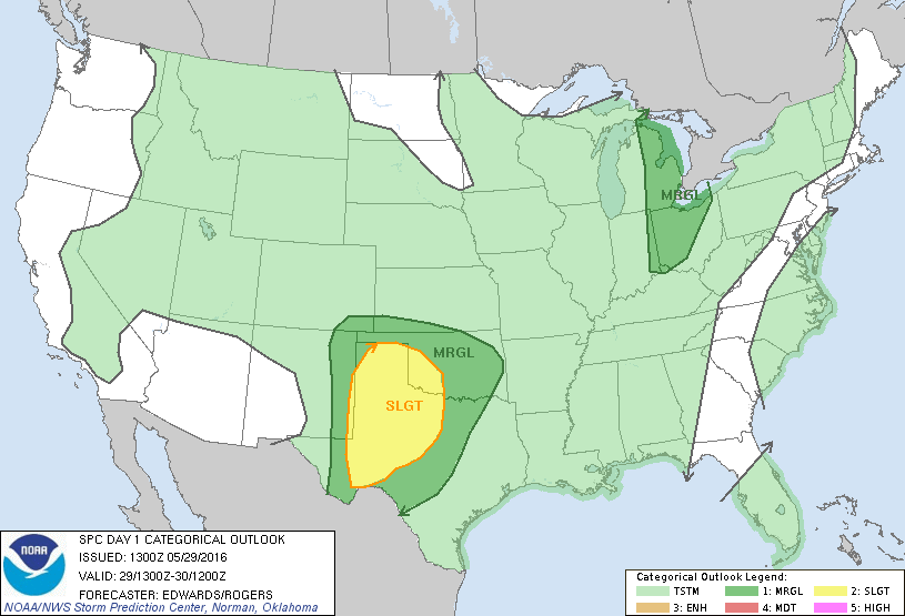
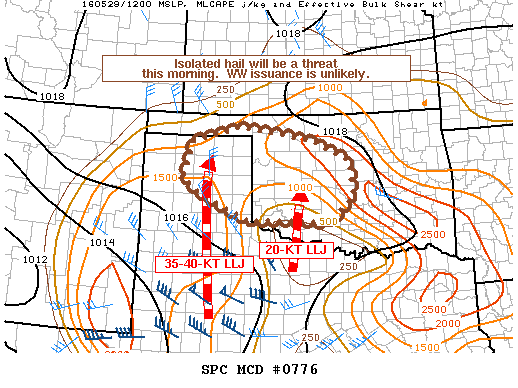
NOAA Storm Prediction Center Severe Thunderstorm Watch 227

Alomar Sharpe Sunday, May 29, 2016 // 2:03 pm

WW 227 SEVERE TSTM NM OK TX 291900Z – 300300Z URGENT – IMMEDIATE BROADCAST REQUESTED SEVERE THUNDERSTORM WATCH NUMBER 227 NWS STORM PREDICTION CENTER NORMAN OK 200 PM CDT SUN MAY 29 2016 THE NWS STORM PREDICTION CENTER HAS ISSUED A * SEVERE THUNDERSTORM WATCH FOR PORTIONS OF EASTERN NEW MEXICO WESTERN OKLAHOMA THE TEXAS PANHANDLE…SOUTH PLAINS…AND LOW ROLLING PLAINS… Read more →

Posted in Archive, Severe Weather Discussions | Tagged Severe Weather, Watches and Warnings, weather
NOAA Storm Prediction Center Mesoscale Discussion 778

NOAA Storm Prediction Center Mesoscale Discussion 778

Alomar Sharpe Sunday, May 29, 2016 // 1:34 pm

MD 0778 CONCERNING SEVERE POTENTIAL…WATCH UNLIKELY FOR SERN LWR MICHIGAN AND ADJACENT NERN IND/NWRN OH MESOSCALE DISCUSSION 0778 NWS STORM PREDICTION CENTER NORMAN OK 0134 PM CDT SUN MAY 29 2016 AREAS AFFECTED…SERN LWR MICHIGAN AND ADJACENT NERN IND/NWRN OH CONCERNING…SEVERE POTENTIAL…WATCH UNLIKELY VALID 291834Z – 292030Z PROBABILITY OF WATCH ISSUANCE…20 PERCENT SUMMARY…DEVELOPING THUNDERSTORM ACTIVITY MAY BE ACCOMPANIED BY AT… Read more →

Posted in Archive, Severe Weather Discussions | Tagged Severe Weather, Watches and Warnings, weather
NOAA Storm Prediction Center Mesoscale Discussion 777

NOAA Storm Prediction Center Mesoscale Discussion 777

Alomar Sharpe Sunday, May 29, 2016 // 12:49 pm

MD 0777 CONCERNING SEVERE POTENTIAL…WATCH POSSIBLE FOR FAR EASTERN NEW MEXICO AND PARTS OF THE TEXAS AND OKLAHOMA PANHANDLES MESOSCALE DISCUSSION 0777 NWS STORM PREDICTION CENTER NORMAN OK 1248 PM CDT SUN MAY 29 2016 AREAS AFFECTED…FAR EASTERN NEW MEXICO AND PARTS OF THE TEXAS AND OKLAHOMA PANHANDLES CONCERNING…SEVERE POTENTIAL…WATCH POSSIBLE VALID 291748Z – 291945Z PROBABILITY OF WATCH ISSUANCE…40 PERCENT… Read more →

Posted in Archive, Severe Weather Discussions | Tagged Severe Weather, Watches and Warnings, weather
Storm Prediction Center May 29, 2016 Morning Outlook

Storm Prediction Center May 29, 2016 Morning Outlook

Alomar Sharpe Sunday, May 29, 2016 // 8:38 am

SPC 1300Z Day 1 Outlook DAY 1 CONVECTIVE OUTLOOK NWS STORM PREDICTION CENTER NORMAN OK 0800 AM CDT SUN MAY 29 2016 VALID 291300Z – 301200Z …THERE IS A SLGT RISK OF SEVERE THUNDERSTORMS PORTIONS SRN PLAINS… …THERE IS A MRGL RISK OF SEVERE THUNDERSTORMS SURROUNDING SRN PLAINS SLGT RISK… …THERE IS A MRGL RISK OF SEVERE THUNDERSTORMS ERN LOWER… Read more →

Posted in Archive, Severe Weather Discussions | Tagged Severe Weather, weather
NOAA Storm Prediction Center Mesoscale Discussion 776

NOAA Storm Prediction Center Mesoscale Discussion 776

Alomar Sharpe Sunday, May 29, 2016 // 7:53 am

MD 0776 CONCERNING SEVERE POTENTIAL…WATCH UNLIKELY FOR NORTHERN TX/OK PANHANDLES INTO NORTHWEST TO CENTRAL OK MESOSCALE DISCUSSION 0776 NWS STORM PREDICTION CENTER NORMAN OK 0752 AM CDT SUN MAY 29 2016 AREAS AFFECTED…NORTHERN TX/OK PANHANDLES INTO NORTHWEST TO CENTRAL OK CONCERNING…SEVERE POTENTIAL…WATCH UNLIKELY VALID 291252Z – 291515Z PROBABILITY OF WATCH ISSUANCE…20 PERCENT SUMMARY…ISOLATED HAIL /APPROACHING AND/OR EXCEEDING 1 INCH IN… Read more →

Posted in Archive, Severe Weather Discussions | Tagged Severe Weather, Watches and Warnings, weather
← Previous 1 … 454 455 456 … 2,028 Next →

Today’s Severe Weather Threat

SVR WX THREAT

Today’s Tornado Threat

SVR WX THREAT

Search The Site

Contributing Scientists

  • Alomar Sharpe
  • Amber Kulick
  • Branden Walker
  • Chris Vagasky
  • Colt Murray
  • Emily Riter
  • Kendall Junker
  • Matt Breland
  • Nick Lilja
  • NickelBlock Staff
  • Noah Gower

Wx Topics

2019 Atlantic Hurricane Season 2020 Atlantic hurricane Season Alabama Weather Amarillo weather Atlantic Hurricane Season Coronavirus COVID-19 COVID19 Earthquakes Flooding Geology Gulf Coast Weather hail hurricanes Louisiana Weather Mississippi Weather rain Severe Weather snow Texas Weather Thunderstorms Tornadoes Tropical Depressions Tropical Storms Tropical Weather tropics USGS Watches and Warnings weather Wind

What We Cover

  • Archive (10,136)
  • Climate (64)
  • Education (230)
  • Environment (8)
  • Forecasting (467)
  • Geology (210)
  • High Plains Weather (119)
  • Midwest Weather (35)
  • Northeast Weather (13)
  • Northwest Weather (5)
  • Not Weather (93)
  • Research (31)
  • River Flooding (23)
  • Severe Weather Discussions (8,640)
  • South Plains Weather (69)
  • Southeast Weather (312)
  • Space (19)
  • Storm Chasing (86)
  • Tropics (450)
  • Weather & Sports (4)
  • Weather & TV (37)
  • Weather History (8)
  • West Coast Weather (4)

Research

  • Conclusion: How multiple variables control TX/OK panhandle Spring severe weather
  • Findings: How multiple variables control TX/OK panhandle Spring severe weather
  • Methods: How multiple variables control TX/OK panhandle Spring severe weather
  • Introduction: How multiple variables control TX/OK panhandle Spring severe weather
  • Works Cited: How multiple variables control TX/OK panhandle Spring severe weather

Popular This Month

  • Remember that “Arctic Blast” people were posting about? Buckle up (6,957)
  • Another “Arctic Blast!” headed to the southeast says social media-rologists (2,420)
  • Arctic blast plunges Mississippi into ice age-like conditions colder than one of the moons of Jupiter (2,410)
  • More cold and snow has South Mississippi feeling like South Manitoba (1,888)
  • More wintry weather possible in South Mississippi next week (1,854)
  • Enough with the “Meteorologists get paid to be wrong” (1,617)
  • Afternoon Update: Snow possible for South Mississippi (960)
  • CIPS Analogs showing thunderstorms, possible severe weather, late next week for south Mississippi (949)
  • Freezing weather won’t kill all mosquitos (664)
  • Jan 16, south Mississippi morning snowfall update (541)
  • Instantly freeze water to make stalagmites (333)
  • Will it snow? A brief look at the steps to get it (318)

Primary Menu

  • About us
    • About us
    • How We Forecast
    • Archives
  • Our Services
    • Live Stream: Severe Weather Discussions
    • Go Storm Chasing
    • Pictures
  • Contact Us!
  • Jobs
  • Weather Safety
    • Weather Safety
    • Hurricane Preparedness Tips
    • Road Conditions
    • Current Conditions
    • South Mississippi river forecasts
    • Forecasting Presentation
  • Login

Secondary Menu

  • Severe Weather Outlook
    • Severe Outlook through Day 8
    • Severe Outlook By State
    • Today’s Severe Weather Threat
    • Today’s Tornado Threat
    • Today’s Severe Wind Threat
    • Today’s Severe Hail Threat
    • Excessive Rainfall Forecasts
  • Short Term Forecast
    • Current Radar & Satellite
    • Detailed National Forecast Discussion
    • National Surface Maps
    • National Temperatures
    • National Precipitation Chances
    • National Precipitation Estimates
    • National Snowfall Estimates
    • National Ice Estimates
    • National Convective Outlook
    • Public RAPTOR Map
    • Model Data Viewer
  • Tropics
  • 10 Day Trend
  • Seasonal Discussion

Copyright © 2026 NickelBlock Forecasting.

Powered by WordPress and Path. Back to Top

Google+
  • About us
  • Our Services
  • Contact Us!
  • Jobs
  • Weather Safety
  • Login