Primary Menu Search
  • About us
    • About us
    • How We Forecast
    • Archives
  • Our Services
    • Live Stream: Severe Weather Discussions
    • Go Storm Chasing
    • Pictures
  • Contact Us!
  • Jobs
  • Weather Safety
    • Weather Safety
    • Hurricane Preparedness Tips
    • Road Conditions
    • Current Conditions
    • South Mississippi river forecasts
    • Forecasting Presentation
  • Login

NickelBlock Forecasting

Funny name. Serious data.

Secondary Menu
  • Severe Weather Outlook
    • Severe Outlook through Day 8
    • Severe Outlook By State
    • Today’s Severe Weather Threat
    • Today’s Tornado Threat
    • Today’s Severe Wind Threat
    • Today’s Severe Hail Threat
    • Excessive Rainfall Forecasts
  • Short Term Forecast
    • Current Radar & Satellite
    • Detailed National Forecast Discussion
    • National Surface Maps
    • National Temperatures
    • National Precipitation Chances
    • National Precipitation Estimates
    • National Snowfall Estimates
    • National Ice Estimates
    • National Convective Outlook
    • Public RAPTOR Map
    • Model Data Viewer
  • Tropics
  • 10 Day Trend
  • Seasonal Discussion
You are here: Home ∼ Page 441
NOAA Storm Prediction Center Mesoscale Discussion 814

NOAA Storm Prediction Center Mesoscale Discussion 814

Alomar Sharpe Saturday, June 4, 2016 // 2:14 pm

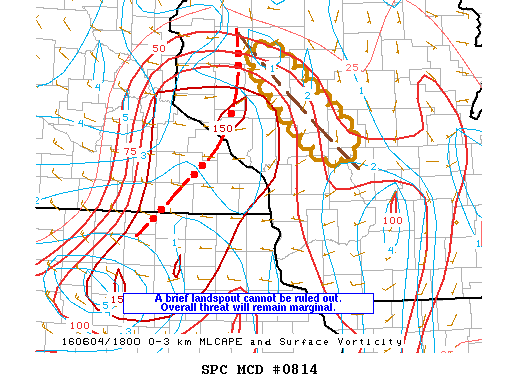
MD 0814 CONCERNING SEVERE POTENTIAL…WATCH UNLIKELY FOR NWRN THROUGH WCNTRL WI MESOSCALE DISCUSSION 0814 NWS STORM PREDICTION CENTER NORMAN OK 0213 PM CDT SAT JUN 04 2016 AREAS AFFECTED…NWRN THROUGH WCNTRL WI CONCERNING…SEVERE POTENTIAL…WATCH UNLIKELY VALID 041913Z – 042115Z PROBABILITY OF WATCH ISSUANCE…5 PERCENT SUMMARY…A BRIEF LANDSPOUT CANNOT BE RULED OUT OVER A PORTION OF WCNTRL WI THIS AFTERNOON. A… Read more →

Posted in Archive, Severe Weather Discussions | Tagged Severe Weather, Watches and Warnings, weather
NOAA Storm Prediction Center Mesoscale Discussion 813

NOAA Storm Prediction Center Mesoscale Discussion 813

Alomar Sharpe Saturday, June 4, 2016 // 12:34 pm

MD 0813 CONCERNING SEVERE POTENTIAL…WATCH POSSIBLE FOR PORTIONS OF WRN/CENTRAL VA…WRN MD…WV PANHANDLE MESOSCALE DISCUSSION 0813 NWS STORM PREDICTION CENTER NORMAN OK 1233 PM CDT SAT JUN 04 2016 AREAS AFFECTED…PORTIONS OF WRN/CENTRAL VA…WRN MD…WV PANHANDLE CONCERNING…SEVERE POTENTIAL…WATCH POSSIBLE VALID 041733Z – 041930Z PROBABILITY OF WATCH ISSUANCE…40 PERCENT SUMMARY…AN INCREASE IN THUNDERSTORM COVERAGE IS EXPECTED THIS AFTERNOON WITH THE STRONGEST… Read more →

Posted in Archive, Severe Weather Discussions | Tagged Severe Weather, Watches and Warnings, weather
NOAA Storm Prediction Center Mesoscale Discussion 812

NOAA Storm Prediction Center Mesoscale Discussion 812

Alomar Sharpe Saturday, June 4, 2016 // 11:45 am

MD 0812 CONCERNING SEVERE POTENTIAL…WATCH POSSIBLE FOR ERN TN THROUGH ERN KY…SRN AND CNTRL WV AND WRN VA MESOSCALE DISCUSSION 0812 NWS STORM PREDICTION CENTER NORMAN OK 1144 AM CDT SAT JUN 04 2016 AREAS AFFECTED…ERN TN THROUGH ERN KY…SRN AND CNTRL WV AND WRN VA CONCERNING…SEVERE POTENTIAL…WATCH POSSIBLE VALID 041644Z – 041845Z PROBABILITY OF WATCH ISSUANCE…60 PERCENT SUMMARY…SCATTERED STORMS… Read more →

Posted in Archive, Severe Weather Discussions | Tagged Severe Weather, Watches and Warnings, weather
NOAA Storm Prediction Center Mesoscale Discussion 811

NOAA Storm Prediction Center Mesoscale Discussion 811

Alomar Sharpe Saturday, June 4, 2016 // 9:53 am

MD 0811 CONCERNING SEVERE POTENTIAL…WATCH UNLIKELY FOR SWRN LA MESOSCALE DISCUSSION 0811 NWS STORM PREDICTION CENTER NORMAN OK 0952 AM CDT SAT JUN 04 2016 AREAS AFFECTED…SWRN LA CONCERNING…SEVERE POTENTIAL…WATCH UNLIKELY VALID 041452Z – 041645Z PROBABILITY OF WATCH ISSUANCE…5 PERCENT SUMMARY…STORMS WILL POSE A THREAT FOR A FEW STRONG WIND GUSTS OVER SWRN LA THIS MORNING. THOUGH A WW IS… Read more →

Posted in Archive, Severe Weather Discussions | Tagged Severe Weather, Watches and Warnings, weather
Storm Prediction Center Jun 4, 2016 Morning Outlook

Storm Prediction Center Jun 4, 2016 Morning Outlook

Alomar Sharpe Saturday, June 4, 2016 // 8:40 am

SPC 1300Z Day 1 Outlook DAY 1 CONVECTIVE OUTLOOK NWS STORM PREDICTION CENTER NORMAN OK 0751 AM CDT SAT JUN 04 2016 VALID 041300Z – 051200Z …THERE IS A SLGT RISK OF SEVERE THUNDERSTORMS ACROSS THE OH/TN RIVER VALLEYS TO MID-ATLANTIC STATES… …THERE IS A MRGL RISK OF SEVERE THUNDERSTORMS FROM THE MIDWEST/TN VALLEY TO THE MID-ATLANTIC STATES… …SUMMARY… THUNDERSTORMS… Read more →

Posted in Archive, Severe Weather Discussions | Tagged Severe Weather, weather
← Previous 1 … 440 441 442 … 2,028 Next →

Today’s Severe Weather Threat

SVR WX THREAT

Today’s Tornado Threat

SVR WX THREAT

Search The Site

Contributing Scientists

  • Alomar Sharpe
  • Amber Kulick
  • Branden Walker
  • Chris Vagasky
  • Colt Murray
  • Emily Riter
  • Kendall Junker
  • Matt Breland
  • Nick Lilja
  • NickelBlock Staff
  • Noah Gower

Wx Topics

2019 Atlantic Hurricane Season 2020 Atlantic hurricane Season Alabama Weather Amarillo weather Atlantic Hurricane Season Coronavirus COVID-19 COVID19 Earthquakes Flooding Geology Gulf Coast Weather hail hurricanes Louisiana Weather Mississippi Weather rain Severe Weather snow Texas Weather Thunderstorms Tornadoes Tropical Depressions Tropical Storms Tropical Weather tropics USGS Watches and Warnings weather Wind

What We Cover

  • Archive (10,136)
  • Climate (64)
  • Education (230)
  • Environment (8)
  • Forecasting (467)
  • Geology (210)
  • High Plains Weather (119)
  • Midwest Weather (35)
  • Northeast Weather (13)
  • Northwest Weather (5)
  • Not Weather (93)
  • Research (31)
  • River Flooding (23)
  • Severe Weather Discussions (8,640)
  • South Plains Weather (69)
  • Southeast Weather (312)
  • Space (19)
  • Storm Chasing (86)
  • Tropics (450)
  • Weather & Sports (4)
  • Weather & TV (37)
  • Weather History (8)
  • West Coast Weather (4)

Research

  • Conclusion: How multiple variables control TX/OK panhandle Spring severe weather
  • Findings: How multiple variables control TX/OK panhandle Spring severe weather
  • Methods: How multiple variables control TX/OK panhandle Spring severe weather
  • Introduction: How multiple variables control TX/OK panhandle Spring severe weather
  • Works Cited: How multiple variables control TX/OK panhandle Spring severe weather

Popular This Month

  • Remember that “Arctic Blast” people were posting about? Buckle up (6,957)
  • Another “Arctic Blast!” headed to the southeast says social media-rologists (2,420)
  • Arctic blast plunges Mississippi into ice age-like conditions colder than one of the moons of Jupiter (2,410)
  • More cold and snow has South Mississippi feeling like South Manitoba (1,888)
  • More wintry weather possible in South Mississippi next week (1,854)
  • Enough with the “Meteorologists get paid to be wrong” (1,617)
  • Afternoon Update: Snow possible for South Mississippi (960)
  • CIPS Analogs showing thunderstorms, possible severe weather, late next week for south Mississippi (949)
  • Freezing weather won’t kill all mosquitos (664)
  • Jan 16, south Mississippi morning snowfall update (541)
  • Instantly freeze water to make stalagmites (333)
  • Will it snow? A brief look at the steps to get it (318)

Primary Menu

  • About us
    • About us
    • How We Forecast
    • Archives
  • Our Services
    • Live Stream: Severe Weather Discussions
    • Go Storm Chasing
    • Pictures
  • Contact Us!
  • Jobs
  • Weather Safety
    • Weather Safety
    • Hurricane Preparedness Tips
    • Road Conditions
    • Current Conditions
    • South Mississippi river forecasts
    • Forecasting Presentation
  • Login

Secondary Menu

  • Severe Weather Outlook
    • Severe Outlook through Day 8
    • Severe Outlook By State
    • Today’s Severe Weather Threat
    • Today’s Tornado Threat
    • Today’s Severe Wind Threat
    • Today’s Severe Hail Threat
    • Excessive Rainfall Forecasts
  • Short Term Forecast
    • Current Radar & Satellite
    • Detailed National Forecast Discussion
    • National Surface Maps
    • National Temperatures
    • National Precipitation Chances
    • National Precipitation Estimates
    • National Snowfall Estimates
    • National Ice Estimates
    • National Convective Outlook
    • Public RAPTOR Map
    • Model Data Viewer
  • Tropics
  • 10 Day Trend
  • Seasonal Discussion

Copyright © 2026 NickelBlock Forecasting.

Powered by WordPress and Path. Back to Top

Google+
  • About us
  • Our Services
  • Contact Us!
  • Jobs
  • Weather Safety
  • Login