Primary Menu Search
  • About us
    • About us
    • How We Forecast
    • Archives
  • Our Services
    • Live Stream: Severe Weather Discussions
    • Go Storm Chasing
    • Pictures
  • Contact Us!
  • Jobs
  • Weather Safety
    • Weather Safety
    • Hurricane Preparedness Tips
    • Road Conditions
    • Current Conditions
    • South Mississippi river forecasts
    • Forecasting Presentation
  • Login

NickelBlock Forecasting

Funny name. Serious data.

Secondary Menu
  • Severe Weather Outlook
    • Severe Outlook through Day 8
    • Severe Outlook By State
    • Today’s Severe Weather Threat
    • Today’s Tornado Threat
    • Today’s Severe Wind Threat
    • Today’s Severe Hail Threat
    • Excessive Rainfall Forecasts
  • Short Term Forecast
    • Current Radar & Satellite
    • Detailed National Forecast Discussion
    • National Surface Maps
    • National Temperatures
    • National Precipitation Chances
    • National Precipitation Estimates
    • National Snowfall Estimates
    • National Ice Estimates
    • National Convective Outlook
    • Public RAPTOR Map
    • Model Data Viewer
  • Tropics
  • 10 Day Trend
  • Seasonal Discussion
You are here: Home ∼ Page 413
Storm Prediction Center Jun 10, 2016 Late Morning Outlook

Storm Prediction Center Jun 10, 2016 Late Morning Outlook

Alomar Sharpe Friday, June 10, 2016 // 4:38 pm

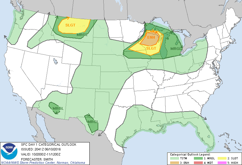
SPC 1630Z Day 1 Outlook DAY 1 CONVECTIVE OUTLOOK NWS STORM PREDICTION CENTER NORMAN OK 1133 AM CDT FRI JUN 10 2016 VALID 101630Z – 111200Z …THERE IS AN ENH RISK OF SEVERE THUNDERSTORMS OVER EAST CENTRAL MN INTO NRN WI… …THERE IS A SLGT RISK OF SEVERE THUNDERSTORMS OVER THE UPPER MIDWEST… …THERE IS A SLGT RISK OF SEVERE… Read more →

Posted in Archive, Severe Weather Discussions | Tagged Severe Weather, weather

NOAA Storm Prediction Center Severe Thunderstorm Watch 244

Alomar Sharpe Friday, June 10, 2016 // 4:05 pm

WW 244 SEVERE TSTM MT 102105Z – 110400Z URGENT – IMMEDIATE BROADCAST REQUESTED SEVERE THUNDERSTORM WATCH NUMBER 244 NWS STORM PREDICTION CENTER NORMAN OK 305 PM MDT FRI JUN 10 2016 THE NWS STORM PREDICTION CENTER HAS ISSUED A * SEVERE THUNDERSTORM WATCH FOR PORTIONS OF CENTRAL MONTANA * EFFECTIVE THIS FRIDAY AFTERNOON AND EVENING FROM 305 PM UNTIL 1000… Read more →

Posted in Archive, Severe Weather Discussions | Tagged Severe Weather, Watches and Warnings, weather
NOAA Storm Prediction Center Mesoscale Discussion 865

NOAA Storm Prediction Center Mesoscale Discussion 865

Alomar Sharpe Friday, June 10, 2016 // 3:42 pm

MD 0865 CONCERNING SEVERE POTENTIAL…WATCH UNLIKELY FOR SE/S-CNTRL AZ MESOSCALE DISCUSSION 0865 NWS STORM PREDICTION CENTER NORMAN OK 0341 PM CDT FRI JUN 10 2016 AREAS AFFECTED…SE/S-CNTRL AZ CONCERNING…SEVERE POTENTIAL…WATCH UNLIKELY VALID 102041Z – 102215Z PROBABILITY OF WATCH ISSUANCE…20 PERCENT SUMMARY…ISOLATED DAMAGING WIND GUSTS ARE POSSIBLE DURING THE NEXT SEVERAL HOURS AS TSTMS DEVELOP OVER SE AZ AND MOVE NWWD… Read more →

Posted in Archive, Severe Weather Discussions | Tagged Severe Weather, Watches and Warnings, weather
NOAA Storm Prediction Center Mesoscale Discussion 864

NOAA Storm Prediction Center Mesoscale Discussion 864

Alomar Sharpe Friday, June 10, 2016 // 3:22 pm

MD 0864 CONCERNING SEVERE POTENTIAL…WATCH POSSIBLE FOR WRN/CNTRL MT MESOSCALE DISCUSSION 0864 NWS STORM PREDICTION CENTER NORMAN OK 0321 PM CDT FRI JUN 10 2016 AREAS AFFECTED…WRN/CNTRL MT CONCERNING…SEVERE POTENTIAL…WATCH POSSIBLE VALID 102021Z – 102115Z PROBABILITY OF WATCH ISSUANCE…40 PERCENT SUMMARY…TSTM INITIATION IS EXPECTED DURING THE NEXT FEW HOURS. ONCE INITIATION OCCURS…THE OVERALL ENVIRONMENT IS FAVORABLE FOR SUPERCELLS CAPABLE OF… Read more →

Posted in Archive, Severe Weather Discussions | Tagged Severe Weather, Watches and Warnings, weather

NOAA Storm Prediction Center Severe Thunderstorm Watch 243

Alomar Sharpe Friday, June 10, 2016 // 3:18 pm

WW 243 SEVERE TSTM IA MN WI 102015Z – 110200Z URGENT – IMMEDIATE BROADCAST REQUESTED SEVERE THUNDERSTORM WATCH NUMBER 243 NWS STORM PREDICTION CENTER NORMAN OK 315 PM CDT FRI JUN 10 2016 THE NWS STORM PREDICTION CENTER HAS ISSUED A * SEVERE THUNDERSTORM WATCH FOR PORTIONS OF EXTREME NORTH CENTRAL AND NORTHEAST IOWA SOUTH CENTRAL AND SOUTHEAST MINNESOTA SOUTHWEST… Read more →

Posted in Archive, Severe Weather Discussions | Tagged Severe Weather, Watches and Warnings, weather
← Previous 1 … 412 413 414 … 2,028 Next →

Today’s Severe Weather Threat

SVR WX THREAT

Today’s Tornado Threat

SVR WX THREAT

Search The Site

Contributing Scientists

  • Alomar Sharpe
  • Amber Kulick
  • Branden Walker
  • Chris Vagasky
  • Colt Murray
  • Emily Riter
  • Kendall Junker
  • Matt Breland
  • Nick Lilja
  • NickelBlock Staff
  • Noah Gower

Wx Topics

2019 Atlantic Hurricane Season 2020 Atlantic hurricane Season Alabama Weather Amarillo weather Atlantic Hurricane Season Coronavirus COVID-19 COVID19 Earthquakes Flooding Geology Gulf Coast Weather hail hurricanes Louisiana Weather Mississippi Weather rain Severe Weather snow Texas Weather Thunderstorms Tornadoes Tropical Depressions Tropical Storms Tropical Weather tropics USGS Watches and Warnings weather Wind

What We Cover

  • Archive (10,136)
  • Climate (64)
  • Education (230)
  • Environment (8)
  • Forecasting (467)
  • Geology (210)
  • High Plains Weather (119)
  • Midwest Weather (35)
  • Northeast Weather (13)
  • Northwest Weather (5)
  • Not Weather (93)
  • Research (31)
  • River Flooding (23)
  • Severe Weather Discussions (8,640)
  • South Plains Weather (69)
  • Southeast Weather (312)
  • Space (19)
  • Storm Chasing (86)
  • Tropics (450)
  • Weather & Sports (4)
  • Weather & TV (37)
  • Weather History (8)
  • West Coast Weather (4)

Research

  • Conclusion: How multiple variables control TX/OK panhandle Spring severe weather
  • Findings: How multiple variables control TX/OK panhandle Spring severe weather
  • Methods: How multiple variables control TX/OK panhandle Spring severe weather
  • Introduction: How multiple variables control TX/OK panhandle Spring severe weather
  • Works Cited: How multiple variables control TX/OK panhandle Spring severe weather

Popular This Month

  • Remember that “Arctic Blast” people were posting about? Buckle up (6,957)
  • Another “Arctic Blast!” headed to the southeast says social media-rologists (2,420)
  • Arctic blast plunges Mississippi into ice age-like conditions colder than one of the moons of Jupiter (2,410)
  • More cold and snow has South Mississippi feeling like South Manitoba (1,888)
  • More wintry weather possible in South Mississippi next week (1,854)
  • Enough with the “Meteorologists get paid to be wrong” (1,617)
  • Afternoon Update: Snow possible for South Mississippi (960)
  • CIPS Analogs showing thunderstorms, possible severe weather, late next week for south Mississippi (949)
  • Freezing weather won’t kill all mosquitos (664)
  • Jan 16, south Mississippi morning snowfall update (541)
  • Instantly freeze water to make stalagmites (333)
  • Will it snow? A brief look at the steps to get it (318)

Primary Menu

  • About us
    • About us
    • How We Forecast
    • Archives
  • Our Services
    • Live Stream: Severe Weather Discussions
    • Go Storm Chasing
    • Pictures
  • Contact Us!
  • Jobs
  • Weather Safety
    • Weather Safety
    • Hurricane Preparedness Tips
    • Road Conditions
    • Current Conditions
    • South Mississippi river forecasts
    • Forecasting Presentation
  • Login

Secondary Menu

  • Severe Weather Outlook
    • Severe Outlook through Day 8
    • Severe Outlook By State
    • Today’s Severe Weather Threat
    • Today’s Tornado Threat
    • Today’s Severe Wind Threat
    • Today’s Severe Hail Threat
    • Excessive Rainfall Forecasts
  • Short Term Forecast
    • Current Radar & Satellite
    • Detailed National Forecast Discussion
    • National Surface Maps
    • National Temperatures
    • National Precipitation Chances
    • National Precipitation Estimates
    • National Snowfall Estimates
    • National Ice Estimates
    • National Convective Outlook
    • Public RAPTOR Map
    • Model Data Viewer
  • Tropics
  • 10 Day Trend
  • Seasonal Discussion

Copyright © 2026 NickelBlock Forecasting.

Powered by WordPress and Path. Back to Top

Google+
  • About us
  • Our Services
  • Contact Us!
  • Jobs
  • Weather Safety
  • Login