Primary Menu Search
  • About us
    • About us
    • How We Forecast
    • Archives
  • Our Services
    • Live Stream: Severe Weather Discussions
    • Go Storm Chasing
    • Pictures
  • Contact Us!
  • Jobs
  • Weather Safety
    • Weather Safety
    • Hurricane Preparedness Tips
    • Road Conditions
    • Current Conditions
    • South Mississippi river forecasts
    • Forecasting Presentation
  • Login

NickelBlock Forecasting

Funny name. Serious data.

Secondary Menu
  • Severe Weather Outlook
    • Severe Outlook through Day 8
    • Severe Outlook By State
    • Today’s Severe Weather Threat
    • Today’s Tornado Threat
    • Today’s Severe Wind Threat
    • Today’s Severe Hail Threat
    • Excessive Rainfall Forecasts
  • Short Term Forecast
    • Current Radar & Satellite
    • Detailed National Forecast Discussion
    • National Surface Maps
    • National Temperatures
    • National Precipitation Chances
    • National Precipitation Estimates
    • National Snowfall Estimates
    • National Ice Estimates
    • National Convective Outlook
    • Public RAPTOR Map
    • Model Data Viewer
  • Tropics
  • 10 Day Trend
  • Seasonal Discussion
You are here: Home ∼ Page 404
Storm Prediction Center Jun 13, 2016 UTC Evening Outlook

Storm Prediction Center Jun 13, 2016 UTC Evening Outlook

Alomar Sharpe Sunday, June 12, 2016 // 8:38 pm

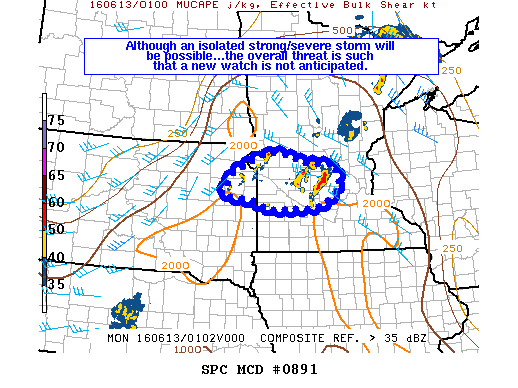
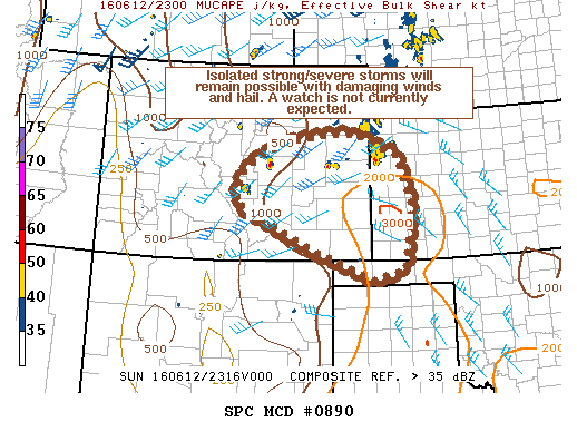
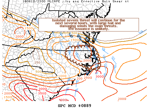
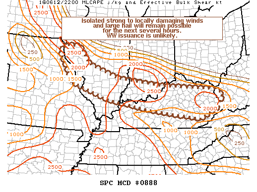
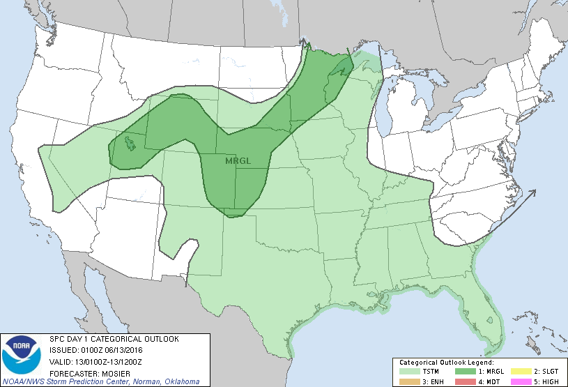
SPC 0100Z Day 1 Outlook DAY 1 CONVECTIVE OUTLOOK NWS STORM PREDICTION CENTER NORMAN OK 0800 PM CDT SUN JUN 12 2016 VALID 130100Z – 131200Z …THERE IS A MRGL RISK OF SEVERE THUNDERSTORMS FROM THE UPPER MS VALLEY WWD INTO THE ERN GREAT BASIN… …SUMMARY… A FEW SEVERE THUNDERSTORMS REMAIN POSSIBLE OVERNIGHT ACROSS CENTRAL MINNESOTA. STRONG TO ISOLATED SEVERE… Read more →

Posted in Archive, Severe Weather Discussions | Tagged Severe Weather, weather
NOAA Storm Prediction Center Mesoscale Discussion 891

NOAA Storm Prediction Center Mesoscale Discussion 891

Alomar Sharpe Sunday, June 12, 2016 // 8:22 pm

MD 0891 CONCERNING SEVERE THUNDERSTORM WATCH 248… FOR PORTIONS OF CENTRAL MN…NERN SD MESOSCALE DISCUSSION 0891 NWS STORM PREDICTION CENTER NORMAN OK 0821 PM CDT SUN JUN 12 2016 AREAS AFFECTED…PORTIONS OF CENTRAL MN…NERN SD CONCERNING…SEVERE THUNDERSTORM WATCH 248… VALID 130121Z – 130245Z THE SEVERE WEATHER THREAT FOR SEVERE THUNDERSTORM WATCH 248 CONTINUES. SUMMARY…ALTHOUGH AN ISOLATED STRONG/SEVERE STORM THREAT MAY… Read more →

Posted in Archive, Severe Weather Discussions | Tagged Severe Weather, Watches and Warnings, weather
NOAA Storm Prediction Center Mesoscale Discussion 890

NOAA Storm Prediction Center Mesoscale Discussion 890

Alomar Sharpe Sunday, June 12, 2016 // 6:42 pm

MD 0890 CONCERNING SEVERE POTENTIAL…WATCH UNLIKELY FOR PORTIONS OF CENTRAL/ERN CO…WRN KS…OK PANHANDLE MESOSCALE DISCUSSION 0890 NWS STORM PREDICTION CENTER NORMAN OK 0641 PM CDT SUN JUN 12 2016 AREAS AFFECTED…PORTIONS OF CENTRAL/ERN CO…WRN KS…OK PANHANDLE CONCERNING…SEVERE POTENTIAL…WATCH UNLIKELY VALID 122341Z – 130145Z PROBABILITY OF WATCH ISSUANCE…20 PERCENT SUMMARY…ISOLATED SEVERE STORMS CAPABLE OF SEVERE HAIL AND WIND WILL CONTINUE THROUGH… Read more →

Posted in Archive, Severe Weather Discussions | Tagged Severe Weather, Watches and Warnings, weather
NOAA Storm Prediction Center Mesoscale Discussion 889

NOAA Storm Prediction Center Mesoscale Discussion 889

Alomar Sharpe Sunday, June 12, 2016 // 6:21 pm

MD 0889 CONCERNING SEVERE POTENTIAL…WATCH UNLIKELY FOR PORTIONS OF SERN VA AND NERN NC MESOSCALE DISCUSSION 0889 NWS STORM PREDICTION CENTER NORMAN OK 0620 PM CDT SUN JUN 12 2016 AREAS AFFECTED…PORTIONS OF SERN VA AND NERN NC CONCERNING…SEVERE POTENTIAL…WATCH UNLIKELY VALID 122320Z – 130045Z PROBABILITY OF WATCH ISSUANCE…20 PERCENT SUMMARY…ISOLATED SEVERE THREAT WILL CONTINUE FOR THE NEXT SEVERAL HOURS…… Read more →

Posted in Archive, Severe Weather Discussions | Tagged Severe Weather, Watches and Warnings, weather
NOAA Storm Prediction Center Mesoscale Discussion 888

NOAA Storm Prediction Center Mesoscale Discussion 888

Alomar Sharpe Sunday, June 12, 2016 // 5:59 pm

MD 0888 CONCERNING SEVERE POTENTIAL…WATCH UNLIKELY FOR PORTIONS OF FAR ERN MO…CNTRL/SRN IL…SRN IND…KY…AND FAR WRN WV MESOSCALE DISCUSSION 0888 NWS STORM PREDICTION CENTER NORMAN OK 0558 PM CDT SUN JUN 12 2016 AREAS AFFECTED…PORTIONS OF FAR ERN MO…CNTRL/SRN IL…SRN IND…KY…AND FAR WRN WV CONCERNING…SEVERE POTENTIAL…WATCH UNLIKELY VALID 122258Z – 130100Z PROBABILITY OF WATCH ISSUANCE…20 PERCENT SUMMARY…ISOLATED STRONG TO LOCALLY… Read more →

Posted in Archive, Severe Weather Discussions | Tagged Severe Weather, Watches and Warnings, weather
← Previous 1 … 403 404 405 … 2,028 Next →

Today’s Severe Weather Threat

SVR WX THREAT

Today’s Tornado Threat

SVR WX THREAT

Search The Site

Contributing Scientists

  • Alomar Sharpe
  • Amber Kulick
  • Branden Walker
  • Chris Vagasky
  • Colt Murray
  • Emily Riter
  • Kendall Junker
  • Matt Breland
  • Nick Lilja
  • NickelBlock Staff
  • Noah Gower

Wx Topics

2019 Atlantic Hurricane Season 2020 Atlantic hurricane Season Alabama Weather Amarillo weather Atlantic Hurricane Season Coronavirus COVID-19 COVID19 Earthquakes Flooding Geology Gulf Coast Weather hail hurricanes Louisiana Weather Mississippi Weather rain Severe Weather snow Texas Weather Thunderstorms Tornadoes Tropical Depressions Tropical Storms Tropical Weather tropics USGS Watches and Warnings weather Wind

What We Cover

  • Archive (10,136)
  • Climate (64)
  • Education (230)
  • Environment (8)
  • Forecasting (467)
  • Geology (210)
  • High Plains Weather (119)
  • Midwest Weather (35)
  • Northeast Weather (13)
  • Northwest Weather (5)
  • Not Weather (93)
  • Research (31)
  • River Flooding (23)
  • Severe Weather Discussions (8,640)
  • South Plains Weather (69)
  • Southeast Weather (312)
  • Space (19)
  • Storm Chasing (86)
  • Tropics (450)
  • Weather & Sports (4)
  • Weather & TV (37)
  • Weather History (8)
  • West Coast Weather (4)

Research

  • Conclusion: How multiple variables control TX/OK panhandle Spring severe weather
  • Findings: How multiple variables control TX/OK panhandle Spring severe weather
  • Methods: How multiple variables control TX/OK panhandle Spring severe weather
  • Introduction: How multiple variables control TX/OK panhandle Spring severe weather
  • Works Cited: How multiple variables control TX/OK panhandle Spring severe weather

Popular This Month

  • Remember that “Arctic Blast” people were posting about? Buckle up (6,957)
  • Another “Arctic Blast!” headed to the southeast says social media-rologists (2,420)
  • Arctic blast plunges Mississippi into ice age-like conditions colder than one of the moons of Jupiter (2,410)
  • More cold and snow has South Mississippi feeling like South Manitoba (1,888)
  • More wintry weather possible in South Mississippi next week (1,854)
  • Enough with the “Meteorologists get paid to be wrong” (1,617)
  • Afternoon Update: Snow possible for South Mississippi (960)
  • CIPS Analogs showing thunderstorms, possible severe weather, late next week for south Mississippi (949)
  • Freezing weather won’t kill all mosquitos (664)
  • Jan 16, south Mississippi morning snowfall update (541)
  • Instantly freeze water to make stalagmites (333)
  • Will it snow? A brief look at the steps to get it (318)

Primary Menu

  • About us
    • About us
    • How We Forecast
    • Archives
  • Our Services
    • Live Stream: Severe Weather Discussions
    • Go Storm Chasing
    • Pictures
  • Contact Us!
  • Jobs
  • Weather Safety
    • Weather Safety
    • Hurricane Preparedness Tips
    • Road Conditions
    • Current Conditions
    • South Mississippi river forecasts
    • Forecasting Presentation
  • Login

Secondary Menu

  • Severe Weather Outlook
    • Severe Outlook through Day 8
    • Severe Outlook By State
    • Today’s Severe Weather Threat
    • Today’s Tornado Threat
    • Today’s Severe Wind Threat
    • Today’s Severe Hail Threat
    • Excessive Rainfall Forecasts
  • Short Term Forecast
    • Current Radar & Satellite
    • Detailed National Forecast Discussion
    • National Surface Maps
    • National Temperatures
    • National Precipitation Chances
    • National Precipitation Estimates
    • National Snowfall Estimates
    • National Ice Estimates
    • National Convective Outlook
    • Public RAPTOR Map
    • Model Data Viewer
  • Tropics
  • 10 Day Trend
  • Seasonal Discussion

Copyright © 2026 NickelBlock Forecasting.

Powered by WordPress and Path. Back to Top

Google+
  • About us
  • Our Services
  • Contact Us!
  • Jobs
  • Weather Safety
  • Login