Primary Menu Search
  • About us
    • About us
    • How We Forecast
    • Archives
  • Our Services
    • Live Stream: Severe Weather Discussions
    • Go Storm Chasing
    • Pictures
  • Contact Us!
  • Jobs
  • Weather Safety
    • Weather Safety
    • Hurricane Preparedness Tips
    • Road Conditions
    • Current Conditions
    • South Mississippi river forecasts
    • Forecasting Presentation
  • Login

NickelBlock Forecasting

Funny name. Serious data.

Secondary Menu
  • Severe Weather Outlook
    • Severe Outlook through Day 8
    • Severe Outlook By State
    • Today’s Severe Weather Threat
    • Today’s Tornado Threat
    • Today’s Severe Wind Threat
    • Today’s Severe Hail Threat
    • Excessive Rainfall Forecasts
  • Short Term Forecast
    • Current Radar & Satellite
    • Detailed National Forecast Discussion
    • National Surface Maps
    • National Temperatures
    • National Precipitation Chances
    • National Precipitation Estimates
    • National Snowfall Estimates
    • National Ice Estimates
    • National Convective Outlook
    • Public RAPTOR Map
    • Model Data Viewer
  • Tropics
  • 10 Day Trend
  • Seasonal Discussion
You are here: Home ∼ Page 389

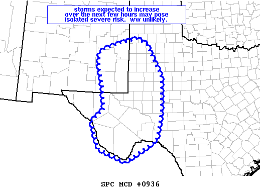
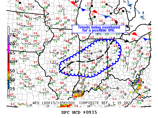
NOAA Storm Prediction Center Severe Thunderstorm Watch 260

Alomar Sharpe Wednesday, June 15, 2016 // 3:00 pm

WW 260 SEVERE TSTM IL IN KY OH 152000Z – 160300Z URGENT – IMMEDIATE BROADCAST REQUESTED SEVERE THUNDERSTORM WATCH NUMBER 260 NWS STORM PREDICTION CENTER NORMAN OK 400 PM EDT WED JUN 15 2016 THE NWS STORM PREDICTION CENTER HAS ISSUED A * SEVERE THUNDERSTORM WATCH FOR PORTIONS OF SOUTHEAST AND SOUTH-CENTRAL ILLINOIS INDIANA FAR NORTHERN KENTUCKY WESTERN OHIO *… Read more →

Posted in Archive, Severe Weather Discussions | Tagged Severe Weather, Watches and Warnings, weather
NOAA Storm Prediction Center Mesoscale Discussion 936

NOAA Storm Prediction Center Mesoscale Discussion 936

Alomar Sharpe Wednesday, June 15, 2016 // 2:25 pm

MD 0936 CONCERNING SEVERE POTENTIAL…WATCH UNLIKELY FOR PORTIONS OF SERN NM AND FAR W TX INTO THE TX SOUTH PLAINS/PERMIAN BASIN MESOSCALE DISCUSSION 0936 NWS STORM PREDICTION CENTER NORMAN OK 0224 PM CDT WED JUN 15 2016 AREAS AFFECTED…PORTIONS OF SERN NM AND FAR W TX INTO THE TX SOUTH PLAINS/PERMIAN BASIN CONCERNING…SEVERE POTENTIAL…WATCH UNLIKELY VALID 151924Z – 152200Z PROBABILITY… Read more →

Posted in Archive, Severe Weather Discussions | Tagged Severe Weather, Watches and Warnings, weather
NOAA Storm Prediction Center Mesoscale Discussion 935

NOAA Storm Prediction Center Mesoscale Discussion 935

Alomar Sharpe Wednesday, June 15, 2016 // 2:24 pm

MD 0935 CONCERNING SEVERE POTENTIAL…WATCH POSSIBLE FOR CNTRL IL…NRN/CNTRL INDIANA…WRN OH MESOSCALE DISCUSSION 0935 NWS STORM PREDICTION CENTER NORMAN OK 0223 PM CDT WED JUN 15 2016 AREAS AFFECTED…CNTRL IL…NRN/CNTRL INDIANA…WRN OH CONCERNING…SEVERE POTENTIAL…WATCH POSSIBLE VALID 151923Z – 152100Z PROBABILITY OF WATCH ISSUANCE…60 PERCENT SUMMARY…POTENTIAL FOR ISOLATED DMGG WIND GUSTS AND HAIL APPEARS TO BE INCREASING ACROSS PARTS OF CNTRL… Read more →

Posted in Archive, Severe Weather Discussions | Tagged Severe Weather, Watches and Warnings, weather

NOAA Storm Prediction Center Tornado Watch 259

Alomar Sharpe Wednesday, June 15, 2016 // 2:11 pm

WW 259 TORNADO WI LM 151910Z – 160100Z URGENT – IMMEDIATE BROADCAST REQUESTED TORNADO WATCH NUMBER 259 NWS STORM PREDICTION CENTER NORMAN OK 210 PM CDT WED JUN 15 2016 THE NWS STORM PREDICTION CENTER HAS ISSUED A * TORNADO WATCH FOR PORTIONS OF WISCONSIN LAKE MICHIGAN * EFFECTIVE THIS WEDNESDAY AFTERNOON AND EVENING FROM 210 PM UNTIL 800 PM… Read more →

Posted in Archive, Severe Weather Discussions | Tagged Severe Weather, Watches and Warnings, weather
NOAA Storm Prediction Center Mesoscale Discussion 934

NOAA Storm Prediction Center Mesoscale Discussion 934

Alomar Sharpe Wednesday, June 15, 2016 // 1:13 pm

MD 0934 CONCERNING SEVERE POTENTIAL…WATCH UNLIKELY FOR FAR ERN KY…SRN WV…WRN VA MESOSCALE DISCUSSION 0934 NWS STORM PREDICTION CENTER NORMAN OK 0112 PM CDT WED JUN 15 2016 AREAS AFFECTED…FAR ERN KY…SRN WV…WRN VA CONCERNING…SEVERE POTENTIAL…WATCH UNLIKELY VALID 151812Z – 151945Z PROBABILITY OF WATCH ISSUANCE…20 PERCENT SUMMARY…A STRONG TO LOCALLY DMGG WIND THREAT MAY ACCOMPANY A TSTM CLUSTER MOVING ACROSS… Read more →

Posted in Archive, Severe Weather Discussions | Tagged Severe Weather, Watches and Warnings, weather
← Previous 1 … 388 389 390 … 2,028 Next →

Today’s Severe Weather Threat

SVR WX THREAT

Today’s Tornado Threat

SVR WX THREAT

Search The Site

Contributing Scientists

  • Alomar Sharpe
  • Amber Kulick
  • Branden Walker
  • Chris Vagasky
  • Colt Murray
  • Emily Riter
  • Kendall Junker
  • Matt Breland
  • Nick Lilja
  • NickelBlock Staff
  • Noah Gower

Wx Topics

2019 Atlantic Hurricane Season 2020 Atlantic hurricane Season Alabama Weather Amarillo weather Atlantic Hurricane Season Coronavirus COVID-19 COVID19 Earthquakes Flooding Geology Gulf Coast Weather hail hurricanes Louisiana Weather Mississippi Weather rain Severe Weather snow Texas Weather Thunderstorms Tornadoes Tropical Depressions Tropical Storms Tropical Weather tropics USGS Watches and Warnings weather Wind

What We Cover

  • Archive (10,136)
  • Climate (64)
  • Education (230)
  • Environment (8)
  • Forecasting (467)
  • Geology (210)
  • High Plains Weather (119)
  • Midwest Weather (35)
  • Northeast Weather (13)
  • Northwest Weather (5)
  • Not Weather (93)
  • Research (31)
  • River Flooding (23)
  • Severe Weather Discussions (8,640)
  • South Plains Weather (69)
  • Southeast Weather (312)
  • Space (19)
  • Storm Chasing (86)
  • Tropics (450)
  • Weather & Sports (4)
  • Weather & TV (37)
  • Weather History (8)
  • West Coast Weather (4)

Research

  • Conclusion: How multiple variables control TX/OK panhandle Spring severe weather
  • Findings: How multiple variables control TX/OK panhandle Spring severe weather
  • Methods: How multiple variables control TX/OK panhandle Spring severe weather
  • Introduction: How multiple variables control TX/OK panhandle Spring severe weather
  • Works Cited: How multiple variables control TX/OK panhandle Spring severe weather

Popular This Month

  • Remember that “Arctic Blast” people were posting about? Buckle up (6,957)
  • Another “Arctic Blast!” headed to the southeast says social media-rologists (2,420)
  • Arctic blast plunges Mississippi into ice age-like conditions colder than one of the moons of Jupiter (2,410)
  • More cold and snow has South Mississippi feeling like South Manitoba (1,888)
  • More wintry weather possible in South Mississippi next week (1,854)
  • Enough with the “Meteorologists get paid to be wrong” (1,617)
  • Afternoon Update: Snow possible for South Mississippi (960)
  • CIPS Analogs showing thunderstorms, possible severe weather, late next week for south Mississippi (949)
  • Freezing weather won’t kill all mosquitos (664)
  • Jan 16, south Mississippi morning snowfall update (541)
  • Instantly freeze water to make stalagmites (333)
  • Will it snow? A brief look at the steps to get it (318)

Primary Menu

  • About us
    • About us
    • How We Forecast
    • Archives
  • Our Services
    • Live Stream: Severe Weather Discussions
    • Go Storm Chasing
    • Pictures
  • Contact Us!
  • Jobs
  • Weather Safety
    • Weather Safety
    • Hurricane Preparedness Tips
    • Road Conditions
    • Current Conditions
    • South Mississippi river forecasts
    • Forecasting Presentation
  • Login

Secondary Menu

  • Severe Weather Outlook
    • Severe Outlook through Day 8
    • Severe Outlook By State
    • Today’s Severe Weather Threat
    • Today’s Tornado Threat
    • Today’s Severe Wind Threat
    • Today’s Severe Hail Threat
    • Excessive Rainfall Forecasts
  • Short Term Forecast
    • Current Radar & Satellite
    • Detailed National Forecast Discussion
    • National Surface Maps
    • National Temperatures
    • National Precipitation Chances
    • National Precipitation Estimates
    • National Snowfall Estimates
    • National Ice Estimates
    • National Convective Outlook
    • Public RAPTOR Map
    • Model Data Viewer
  • Tropics
  • 10 Day Trend
  • Seasonal Discussion

Copyright © 2026 NickelBlock Forecasting.

Powered by WordPress and Path. Back to Top

Google+
  • About us
  • Our Services
  • Contact Us!
  • Jobs
  • Weather Safety
  • Login