Primary Menu Search
  • About us
    • About us
    • How We Forecast
    • Archives
  • Our Services
    • Live Stream: Severe Weather Discussions
    • Go Storm Chasing
    • Pictures
  • Contact Us!
  • Jobs
  • Weather Safety
    • Weather Safety
    • Hurricane Preparedness Tips
    • Road Conditions
    • Current Conditions
    • South Mississippi river forecasts
    • Forecasting Presentation
  • Login

NickelBlock Forecasting

Funny name. Serious data.

Secondary Menu
  • Severe Weather Outlook
    • Severe Outlook through Day 8
    • Severe Outlook By State
    • Today’s Severe Weather Threat
    • Today’s Tornado Threat
    • Today’s Severe Wind Threat
    • Today’s Severe Hail Threat
    • Excessive Rainfall Forecasts
  • Short Term Forecast
    • Current Radar & Satellite
    • Detailed National Forecast Discussion
    • National Surface Maps
    • National Temperatures
    • National Precipitation Chances
    • National Precipitation Estimates
    • National Snowfall Estimates
    • National Ice Estimates
    • National Convective Outlook
    • Public RAPTOR Map
    • Model Data Viewer
  • Tropics
  • 10 Day Trend
  • Seasonal Discussion
You are here: Home ∼ Page 385
Storm Prediction Center Jun 16, 2016 Morning Outlook

Storm Prediction Center Jun 16, 2016 Morning Outlook

Alomar Sharpe Thursday, June 16, 2016 // 8:38 am

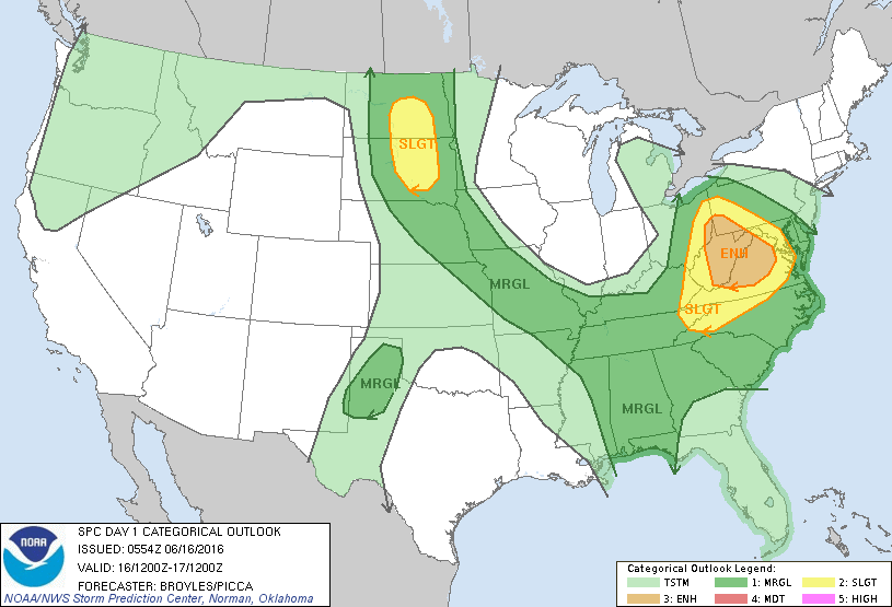
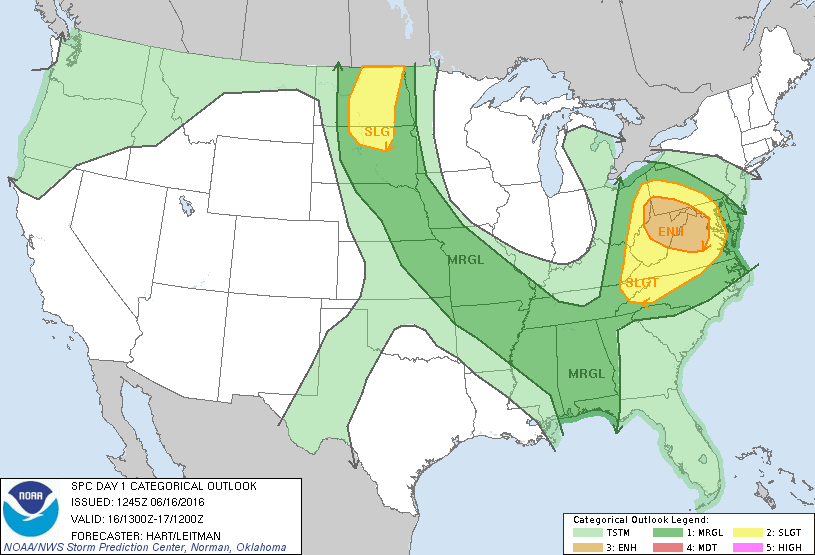
SPC 1300Z Day 1 Outlook DAY 1 CONVECTIVE OUTLOOK NWS STORM PREDICTION CENTER NORMAN OK 0745 AM CDT THU JUN 16 2016 VALID 161300Z – 171200Z …THERE IS AN ENH RISK OF SEVERE THUNDERSTORMS OVER PARTS OF SOUTHEAST OH…NORTHERN WV…SOUTHWEST PA…WESTERN MD…AND NORTHERN VA… …THERE IS A SLGT RISK OF SEVERE THUNDERSTORMS ACROSS PARTS OF THE CENTRAL APPALACHIANS… …THERE IS… Read more →

Posted in Archive, Severe Weather Discussions | Tagged Severe Weather, weather
Storm Prediction Center Jun 16, 2016 Early Morning UTC Day 1 Convective Outlook

Storm Prediction Center Jun 16, 2016 Early Morning UTC Day 1 Convective Outlook

Alomar Sharpe Thursday, June 16, 2016 // 1:38 am

SPC 1200Z Day 1 Outlook DAY 1 CONVECTIVE OUTLOOK NWS STORM PREDICTION CENTER NORMAN OK 1254 AM CDT THU JUN 16 2016 VALID 161200Z – 171200Z …THERE IS AN ENH RISK OF SEVERE THUNDERSTORMS ACROSS PARTS OF ERN OH…WV…VA…SW PA AND WRN MD… …THERE IS A SLGT RISK OF SEVERE THUNDERSTORMS ACROSS PARTS OF THE UPPER OH VALLEY…SRN TO CNTRL… Read more →

Posted in Archive, Severe Weather Discussions | Tagged Severe Weather, weather
NOAA Storm Prediction Center Mesoscale Discussion 947

NOAA Storm Prediction Center Mesoscale Discussion 947

Alomar Sharpe Wednesday, June 15, 2016 // 11:05 pm

MD 0947 CONCERNING SEVERE POTENTIAL…WATCH POSSIBLE FOR NERN MT MESOSCALE DISCUSSION 0947 NWS STORM PREDICTION CENTER NORMAN OK 1104 PM CDT WED JUN 15 2016 AREAS AFFECTED…NERN MT CONCERNING…SEVERE POTENTIAL…WATCH POSSIBLE VALID 160404Z – 160600Z PROBABILITY OF WATCH ISSUANCE…40 PERCENT SUMMARY…STORMS DEVELOPING OVER NERN MT WILL POSE A THREAT FOR MAINLY A FEW INSTANCES OF LARGE HAIL INTO THE EARLY… Read more →

Posted in Archive, Severe Weather Discussions | Tagged Severe Weather, Watches and Warnings, weather
Storm Prediction Center Jun 16, 2016 UTC Evening Outlook

Storm Prediction Center Jun 16, 2016 UTC Evening Outlook

Alomar Sharpe Wednesday, June 15, 2016 // 8:38 pm

SPC 0100Z Day 1 Outlook DAY 1 CONVECTIVE OUTLOOK NWS STORM PREDICTION CENTER NORMAN OK 0759 PM CDT WED JUN 15 2016 VALID 160100Z – 161200Z …THERE IS A SLGT RISK OF SEVERE THUNDERSTORMS ACROSS PARTS OF THE TN VALLEY… …THERE IS A SLGT RISK OF SEVERE THUNDERSTORMS ACROSS PARTS OF THE NRN HIGH PLAINS… …THERE IS A SLGT RISK… Read more →

Posted in Archive, Severe Weather Discussions | Tagged Severe Weather, weather
NOAA Storm Prediction Center Mesoscale Discussion 946

NOAA Storm Prediction Center Mesoscale Discussion 946

Alomar Sharpe Wednesday, June 15, 2016 // 8:25 pm

MD 0946 CONCERNING SEVERE POTENTIAL…WATCH POSSIBLE FOR WCNTRL LOWER MI MESOSCALE DISCUSSION 0946 NWS STORM PREDICTION CENTER NORMAN OK 0824 PM CDT WED JUN 15 2016 AREAS AFFECTED…WCNTRL LOWER MI CONCERNING…SEVERE POTENTIAL…WATCH POSSIBLE VALID 160124Z – 160330Z PROBABILITY OF WATCH ISSUANCE…40 PERCENT SUMMARY…STORMS CROSSING LAKE MI WILL CONTINUE TO POSE A THREAT FOR MAINLY DAMAGING WIND AND HAIL AND POSSIBLY… Read more →

Posted in Archive, Severe Weather Discussions | Tagged Severe Weather, Watches and Warnings, weather
← Previous 1 … 384 385 386 … 2,028 Next →

Today’s Severe Weather Threat

SVR WX THREAT

Today’s Tornado Threat

SVR WX THREAT

Search The Site

Contributing Scientists

  • Alomar Sharpe
  • Amber Kulick
  • Branden Walker
  • Chris Vagasky
  • Colt Murray
  • Emily Riter
  • Kendall Junker
  • Matt Breland
  • Nick Lilja
  • NickelBlock Staff
  • Noah Gower

Wx Topics

2019 Atlantic Hurricane Season 2020 Atlantic hurricane Season Alabama Weather Amarillo weather Atlantic Hurricane Season Coronavirus COVID-19 COVID19 Earthquakes Flooding Geology Gulf Coast Weather hail hurricanes Louisiana Weather Mississippi Weather rain Severe Weather snow Texas Weather Thunderstorms Tornadoes Tropical Depressions Tropical Storms Tropical Weather tropics USGS Watches and Warnings weather Wind

What We Cover

  • Archive (10,136)
  • Climate (64)
  • Education (230)
  • Environment (8)
  • Forecasting (467)
  • Geology (210)
  • High Plains Weather (119)
  • Midwest Weather (35)
  • Northeast Weather (13)
  • Northwest Weather (5)
  • Not Weather (93)
  • Research (31)
  • River Flooding (23)
  • Severe Weather Discussions (8,640)
  • South Plains Weather (69)
  • Southeast Weather (312)
  • Space (19)
  • Storm Chasing (86)
  • Tropics (450)
  • Weather & Sports (4)
  • Weather & TV (37)
  • Weather History (8)
  • West Coast Weather (4)

Research

  • Conclusion: How multiple variables control TX/OK panhandle Spring severe weather
  • Findings: How multiple variables control TX/OK panhandle Spring severe weather
  • Methods: How multiple variables control TX/OK panhandle Spring severe weather
  • Introduction: How multiple variables control TX/OK panhandle Spring severe weather
  • Works Cited: How multiple variables control TX/OK panhandle Spring severe weather

Popular This Month

  • Remember that “Arctic Blast” people were posting about? Buckle up (6,957)
  • Another “Arctic Blast!” headed to the southeast says social media-rologists (2,420)
  • Arctic blast plunges Mississippi into ice age-like conditions colder than one of the moons of Jupiter (2,410)
  • More cold and snow has South Mississippi feeling like South Manitoba (1,888)
  • More wintry weather possible in South Mississippi next week (1,854)
  • Enough with the “Meteorologists get paid to be wrong” (1,617)
  • Afternoon Update: Snow possible for South Mississippi (960)
  • CIPS Analogs showing thunderstorms, possible severe weather, late next week for south Mississippi (949)
  • Freezing weather won’t kill all mosquitos (664)
  • Jan 16, south Mississippi morning snowfall update (541)
  • Instantly freeze water to make stalagmites (333)
  • Will it snow? A brief look at the steps to get it (318)

Primary Menu

  • About us
    • About us
    • How We Forecast
    • Archives
  • Our Services
    • Live Stream: Severe Weather Discussions
    • Go Storm Chasing
    • Pictures
  • Contact Us!
  • Jobs
  • Weather Safety
    • Weather Safety
    • Hurricane Preparedness Tips
    • Road Conditions
    • Current Conditions
    • South Mississippi river forecasts
    • Forecasting Presentation
  • Login

Secondary Menu

  • Severe Weather Outlook
    • Severe Outlook through Day 8
    • Severe Outlook By State
    • Today’s Severe Weather Threat
    • Today’s Tornado Threat
    • Today’s Severe Wind Threat
    • Today’s Severe Hail Threat
    • Excessive Rainfall Forecasts
  • Short Term Forecast
    • Current Radar & Satellite
    • Detailed National Forecast Discussion
    • National Surface Maps
    • National Temperatures
    • National Precipitation Chances
    • National Precipitation Estimates
    • National Snowfall Estimates
    • National Ice Estimates
    • National Convective Outlook
    • Public RAPTOR Map
    • Model Data Viewer
  • Tropics
  • 10 Day Trend
  • Seasonal Discussion

Copyright © 2026 NickelBlock Forecasting.

Powered by WordPress and Path. Back to Top

Google+
  • About us
  • Our Services
  • Contact Us!
  • Jobs
  • Weather Safety
  • Login