9/17/19 – Tropics get active: Humberto, Imelda and TD10
And just like that, things have picked back up again in the Atlantic. There is a Category 2 Hurricane, Humberto. A newly-minted Tropical storm, Imelda and a Tropical Depression east of the Leeward Islands. From the NHC Hurricane Humberto SUMMARY OF 200 PM EDT…1800 UTC…INFORMATION ———————————————- LOCATION…30.8N 72.9W ABOUT 490 MI…785 KM WSW OF BERMUDA MAXIMUM SUSTAINED WINDS…100 MPH…155 KM/H… Read more →
PM Tropical Update – Latest on Invest95L / PTC9 / Humberto
SUMMARY OF 500 PM EDT…2100 UTC…INFORMATION ———————————————- LOCATION…23.7N 74.8W ABOUT 235 MI…380 KM SE OF GREAT ABACO ISLAND ABOUT 310 MI…500 KM SE OF FREEPORT GRAND BAHAMA ISLAND MAXIMUM SUSTAINED WINDS…30 MPH…45 KM/H PRESENT MOVEMENT…NW OR 305 DEGREES AT 8 MPH…13 KM/H MINIMUM CENTRAL PRESSURE…1008 MB…29.77 INCHES DISCUSSION Potential Tropical Cyclone Nine Discussion Number 1 NWS National Hurricane Center Miami… Read more →
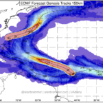
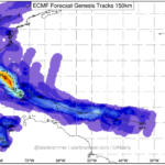
9/12/19 Tropical Update – Overnight model track shift on Invest95L
The model guidance for Invest 95L made a distinct shift overnight to the east. The above image may look like a bit of chicken-scratch, but what it shows is a push to the east in the genesis of a tropical system by the ECMWF computer weather model. And it isn’t just one model that did this. You can also see… Read more →
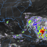
Invest95L drifts toward Gulf of Mexico, chances for tropical development increases
The National Hurricane Center is tracking three different areas for potential tropical development. The closest to the United States is Invest 95L Cu rent model guidance suggests that Invest 95L will drift into the Gulf of Mexico in coming days and that the chances for development – in the available model data, not the official forecast – are between 50-… Read more →

