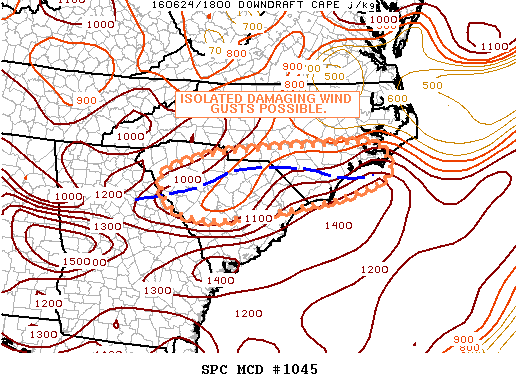
NOAA Storm Prediction Center Mesoscale Discussion 1045
MD 1045 CONCERNING SEVERE POTENTIAL…WATCH UNLIKELY FOR CNTRL SC…S-CNTRL/SE NC MESOSCALE DISCUSSION 1045 NWS STORM PREDICTION CENTER NORMAN OK 0200 PM CDT FRI JUN 24 2016 AREAS AFFECTED…CNTRL SC…S-CNTRL/SE NC CONCERNING…SEVERE POTENTIAL…WATCH UNLIKELY VALID 241900Z – 242100Z PROBABILITY OF WATCH ISSUANCE…20 PERCENT SUMMARY…ISOLATED DAMAGING WIND GUSTS ARE POSSIBLE AS TSTMS DEVELOP ALONG A BOUNDARY EXTENDING ACROSS CNTRL SC INTO SE… Read more →