March 28, morning severe weather discussion
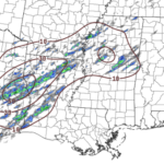
Here is a brief breakdown of some of the severe weather parameters that are being monitored today for Texas, Louisiana and Mississippi.
Here is a brief breakdown of some of the severe weather parameters that are being monitored today for Texas, Louisiana and Mississippi.
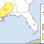
As an area of low pressure moves out of Texas and Oklahoma, it will push a cold front across parts of east Texas, Louisiana and Mississippi. The front will be the catalyst for showers and storms to develop. Some storms may be severe with heavy rain, frequent lightning, damaging wind, hail and the possibility of producing a few tornadoes. The… Read more →
The problem with living in south Mississippi is that feels like severe weather is possible every time a front moves though. The bigger problem? It doesn’t just feel that way, it is that way. As an aside, this is not going to talk about the timeline of events, specific threat levels, or where specific storms will be. This is more… Read more →
As a cluster of storms is brewing in parts of central Louisiana, slowing drifting east-southeast. Radar check pic.twitter.com/aNb7lIA4wc — Nick Lilja (@NickLilja) March 18, 2018 That radar grab was from about 10:30am. Quick update We’ve had a few changes to the forecast since 2am… 1. The tornado threat should be confined to the south side of the cluster of storms… Read more →
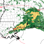
Looking at the latest model guidance and a few things we talked about earlier this week seem to be holding the severe weather threat in South Mississippi – somewhat -in check. While the area is still looking at the threat for heavy rain, frequent lightning, damaging wind, hail and the possibility of a tornado… that threat is a bit lower… Read more →

