Primary Menu Search
  • About us
    • About us
    • How We Forecast
    • Archives
  • Our Services
    • Live Stream: Severe Weather Discussions
    • Go Storm Chasing
    • Pictures
  • Contact Us!
  • Jobs
  • Weather Safety
    • Weather Safety
    • Hurricane Preparedness Tips
    • Road Conditions
    • Current Conditions
    • South Mississippi river forecasts
    • Forecasting Presentation
  • Login

NickelBlock Forecasting

Funny name. Serious data.

Secondary Menu
  • Severe Weather Outlook
    • Severe Outlook through Day 8
    • Severe Outlook By State
    • Today’s Severe Weather Threat
    • Today’s Tornado Threat
    • Today’s Severe Wind Threat
    • Today’s Severe Hail Threat
    • Excessive Rainfall Forecasts
  • Short Term Forecast
    • Current Radar & Satellite
    • Detailed National Forecast Discussion
    • National Surface Maps
    • National Temperatures
    • National Precipitation Chances
    • National Precipitation Estimates
    • National Snowfall Estimates
    • National Ice Estimates
    • National Convective Outlook
    • Public RAPTOR Map
    • Model Data Viewer
  • Tropics
  • 10 Day Trend
  • Seasonal Discussion
You are here: Home ∼ Page 297

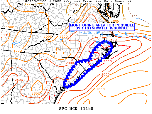
NOAA Storm Prediction Center Severe Thunderstorm Watch 327

Alomar Sharpe Tuesday, July 5, 2016 // 5:55 pm

WW 327 SEVERE TSTM NC CW 052255Z – 060500Z URGENT – IMMEDIATE BROADCAST REQUESTED SEVERE THUNDERSTORM WATCH NUMBER 327 NWS STORM PREDICTION CENTER NORMAN OK 655 PM EDT TUE JUL 5 2016 THE NWS STORM PREDICTION CENTER HAS ISSUED A * SEVERE THUNDERSTORM WATCH FOR PORTIONS OF EASTERN NORTH CAROLINA COASTAL WATERS * EFFECTIVE THIS TUESDAY NIGHT AND WEDNESDAY MORNING… Read more →

Posted in Archive, Severe Weather Discussions | Tagged Severe Weather, Watches and Warnings, weather
NOAA Storm Prediction Center Mesoscale Discussion 1150

NOAA Storm Prediction Center Mesoscale Discussion 1150

Alomar Sharpe Tuesday, July 5, 2016 // 5:30 pm

MD 1150 CONCERNING SEVERE POTENTIAL…WATCH POSSIBLE FOR PORTIONS OF ERN NC/SC MESOSCALE DISCUSSION 1150 NWS STORM PREDICTION CENTER NORMAN OK 0529 PM CDT TUE JUL 05 2016 AREAS AFFECTED…PORTIONS OF ERN NC/SC CONCERNING…SEVERE POTENTIAL…WATCH POSSIBLE VALID 052229Z – 060030Z PROBABILITY OF WATCH ISSUANCE…60 PERCENT SUMMARY…CONVECTIVE CLUSTERS SPREADING EWD TOWARD/ACROSS THE NC/SC COASTAL PLAIN WILL HAVE THE POTENTIAL TO PRODUCE AT… Read more →

Posted in Archive, Severe Weather Discussions | Tagged Severe Weather, Watches and Warnings, weather
NOAA Storm Prediction Center Mesoscale Discussion 1149

NOAA Storm Prediction Center Mesoscale Discussion 1149

Alomar Sharpe Tuesday, July 5, 2016 // 5:18 pm

MD 1149 CONCERNING SEVERE POTENTIAL…WATCH UNLIKELY FOR PORTIONS OF NERN MN MESOSCALE DISCUSSION 1149 NWS STORM PREDICTION CENTER NORMAN OK 0517 PM CDT TUE JUL 05 2016 AREAS AFFECTED…PORTIONS OF NERN MN CONCERNING…SEVERE POTENTIAL…WATCH UNLIKELY VALID 052217Z – 060015Z PROBABILITY OF WATCH ISSUANCE…5 PERCENT SUMMARY…A SMALL CONVECTIVE CLUSTER WILL CONTINUE TRACKING ACROSS PORTIONS OF NERN MN AND COULD PRODUCE SPORADIC… Read more →

Posted in Archive, Severe Weather Discussions | Tagged Severe Weather, Watches and Warnings, weather
NOAA Storm Prediction Center Mesoscale Discussion 1148

NOAA Storm Prediction Center Mesoscale Discussion 1148

Alomar Sharpe Tuesday, July 5, 2016 // 5:08 pm

MD 1148 CONCERNING TORNADO WATCH 323… FOR CNTRL MN…NE SD MESOSCALE DISCUSSION 1148 NWS STORM PREDICTION CENTER NORMAN OK 0508 PM CDT TUE JUL 05 2016 AREAS AFFECTED…CNTRL MN…NE SD CONCERNING…TORNADO WATCH 323… VALID 052208Z – 052345Z THE SEVERE WEATHER THREAT FOR TORNADO WATCH 323 CONTINUES. SUMMARY…ALL SEVERE HAZARDS REMAIN POSSIBLE ACROSS TORNADO WATCH 323. DISCUSSION…REGIONAL RADAR DATA SHOWS TWO… Read more →

Posted in Archive, Severe Weather Discussions | Tagged Severe Weather, Watches and Warnings, weather
NOAA Storm Prediction Center Mesoscale Discussion 1147

NOAA Storm Prediction Center Mesoscale Discussion 1147

Alomar Sharpe Tuesday, July 5, 2016 // 5:00 pm

MD 1147 CONCERNING SEVERE POTENTIAL…WATCH POSSIBLE FOR PORTIONS OF CNTRL/SRN NEB AND NRN KS MESOSCALE DISCUSSION 1147 NWS STORM PREDICTION CENTER NORMAN OK 0459 PM CDT TUE JUL 05 2016 AREAS AFFECTED…PORTIONS OF CNTRL/SRN NEB AND NRN KS CONCERNING…SEVERE POTENTIAL…WATCH POSSIBLE VALID 052159Z – 060030Z PROBABILITY OF WATCH ISSUANCE…40 PERCENT SUMMARY…THE AREA IS BEING MONITORED FOR POSSIBLE UPSCALE-GROWING CONVECTIVE CLUSTERS… Read more →

Posted in Archive, Severe Weather Discussions | Tagged Severe Weather, Watches and Warnings, weather
← Previous 1 … 296 297 298 … 2,028 Next →

Today’s Severe Weather Threat

SVR WX THREAT

Today’s Tornado Threat

SVR WX THREAT

Search The Site

Contributing Scientists

  • Alomar Sharpe
  • Amber Kulick
  • Branden Walker
  • Chris Vagasky
  • Colt Murray
  • Emily Riter
  • Kendall Junker
  • Matt Breland
  • Nick Lilja
  • NickelBlock Staff
  • Noah Gower

Wx Topics

2019 Atlantic Hurricane Season 2020 Atlantic hurricane Season Alabama Weather Amarillo weather Atlantic Hurricane Season Coronavirus COVID-19 COVID19 Earthquakes Flooding Geology Gulf Coast Weather hail hurricanes Louisiana Weather Mississippi Weather rain Severe Weather snow Texas Weather Thunderstorms Tornadoes Tropical Depressions Tropical Storms Tropical Weather tropics USGS Watches and Warnings weather Wind

What We Cover

  • Archive (10,136)
  • Climate (64)
  • Education (230)
  • Environment (8)
  • Forecasting (467)
  • Geology (210)
  • High Plains Weather (119)
  • Midwest Weather (35)
  • Northeast Weather (13)
  • Northwest Weather (5)
  • Not Weather (93)
  • Research (31)
  • River Flooding (23)
  • Severe Weather Discussions (8,640)
  • South Plains Weather (69)
  • Southeast Weather (312)
  • Space (19)
  • Storm Chasing (86)
  • Tropics (450)
  • Weather & Sports (4)
  • Weather & TV (37)
  • Weather History (8)
  • West Coast Weather (4)

Research

  • Conclusion: How multiple variables control TX/OK panhandle Spring severe weather
  • Findings: How multiple variables control TX/OK panhandle Spring severe weather
  • Methods: How multiple variables control TX/OK panhandle Spring severe weather
  • Introduction: How multiple variables control TX/OK panhandle Spring severe weather
  • Works Cited: How multiple variables control TX/OK panhandle Spring severe weather

Popular This Month

  • Remember that “Arctic Blast” people were posting about? Buckle up (6,957)
  • Another “Arctic Blast!” headed to the southeast says social media-rologists (2,420)
  • Arctic blast plunges Mississippi into ice age-like conditions colder than one of the moons of Jupiter (2,410)
  • More cold and snow has South Mississippi feeling like South Manitoba (1,888)
  • More wintry weather possible in South Mississippi next week (1,854)
  • Enough with the “Meteorologists get paid to be wrong” (1,617)
  • Afternoon Update: Snow possible for South Mississippi (960)
  • CIPS Analogs showing thunderstorms, possible severe weather, late next week for south Mississippi (949)
  • Freezing weather won’t kill all mosquitos (664)
  • Jan 16, south Mississippi morning snowfall update (541)
  • Instantly freeze water to make stalagmites (333)
  • Will it snow? A brief look at the steps to get it (318)

Primary Menu

  • About us
    • About us
    • How We Forecast
    • Archives
  • Our Services
    • Live Stream: Severe Weather Discussions
    • Go Storm Chasing
    • Pictures
  • Contact Us!
  • Jobs
  • Weather Safety
    • Weather Safety
    • Hurricane Preparedness Tips
    • Road Conditions
    • Current Conditions
    • South Mississippi river forecasts
    • Forecasting Presentation
  • Login

Secondary Menu

  • Severe Weather Outlook
    • Severe Outlook through Day 8
    • Severe Outlook By State
    • Today’s Severe Weather Threat
    • Today’s Tornado Threat
    • Today’s Severe Wind Threat
    • Today’s Severe Hail Threat
    • Excessive Rainfall Forecasts
  • Short Term Forecast
    • Current Radar & Satellite
    • Detailed National Forecast Discussion
    • National Surface Maps
    • National Temperatures
    • National Precipitation Chances
    • National Precipitation Estimates
    • National Snowfall Estimates
    • National Ice Estimates
    • National Convective Outlook
    • Public RAPTOR Map
    • Model Data Viewer
  • Tropics
  • 10 Day Trend
  • Seasonal Discussion

Copyright © 2026 NickelBlock Forecasting.

Powered by WordPress and Path. Back to Top

Google+
  • About us
  • Our Services
  • Contact Us!
  • Jobs
  • Weather Safety
  • Login