Primary Menu Search
  • About us
    • About us
    • How We Forecast
    • Archives
  • Our Services
    • Live Stream: Severe Weather Discussions
    • Go Storm Chasing
    • Pictures
  • Contact Us!
  • Jobs
  • Weather Safety
    • Weather Safety
    • Hurricane Preparedness Tips
    • Road Conditions
    • Current Conditions
    • South Mississippi river forecasts
    • Forecasting Presentation
  • Login

NickelBlock Forecasting

Funny name. Serious data.

Secondary Menu
  • Severe Weather Outlook
    • Severe Outlook through Day 8
    • Severe Outlook By State
    • Today’s Severe Weather Threat
    • Today’s Tornado Threat
    • Today’s Severe Wind Threat
    • Today’s Severe Hail Threat
    • Excessive Rainfall Forecasts
  • Short Term Forecast
    • Current Radar & Satellite
    • Detailed National Forecast Discussion
    • National Surface Maps
    • National Temperatures
    • National Precipitation Chances
    • National Precipitation Estimates
    • National Snowfall Estimates
    • National Ice Estimates
    • National Convective Outlook
    • Public RAPTOR Map
    • Model Data Viewer
  • Tropics
  • 10 Day Trend
  • Seasonal Discussion
You are here: Home ∼ Page 293

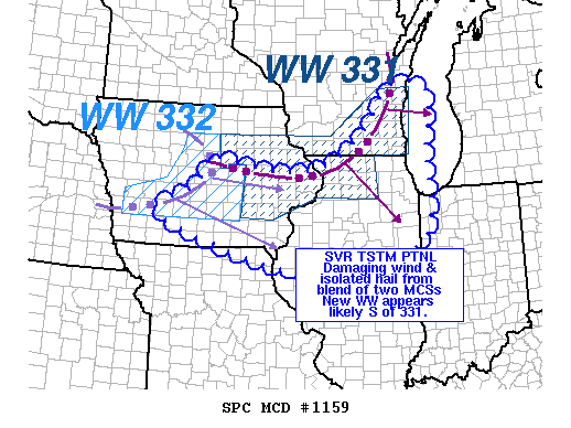
NOAA Storm Prediction Center Severe Thunderstorm Watch 333

Alomar Sharpe Wednesday, July 6, 2016 // 1:55 am

WW 333 SEVERE TSTM IA IL IN LM 060655Z – 061400Z URGENT – IMMEDIATE BROADCAST REQUESTED SEVERE THUNDERSTORM WATCH NUMBER 333 NWS STORM PREDICTION CENTER NORMAN OK 155 AM CDT WED JUL 6 2016 THE NWS STORM PREDICTION CENTER HAS ISSUED A * SEVERE THUNDERSTORM WATCH FOR PORTIONS OF SOUTHEASTERN IOWA NORTHERN AND CENTRAL ILLINOIS NORTHWESTERN INDIANA LAKE MICHIGAN *… Read more →

Posted in Archive, Severe Weather Discussions | Tagged Severe Weather, Watches and Warnings, weather
NOAA Storm Prediction Center Mesoscale Discussion 1160

NOAA Storm Prediction Center Mesoscale Discussion 1160

Alomar Sharpe Wednesday, July 6, 2016 // 1:48 am

MD 1160 CONCERNING SEVERE POTENTIAL…WATCH LIKELY FOR CENTRAL AND EASTERN KS MESOSCALE DISCUSSION 1160 NWS STORM PREDICTION CENTER NORMAN OK 0147 AM CDT WED JUL 06 2016 AREAS AFFECTED…CENTRAL AND EASTERN KS CONCERNING…SEVERE POTENTIAL…WATCH LIKELY VALID 060647Z – 060815Z PROBABILITY OF WATCH ISSUANCE…80 PERCENT SUMMARY…A NEW SEVERE TSTM WATCH WILL BE COORDINATED SHORTLY FOR EASTERN KS AND PERHAPS PARTS OF… Read more →

Posted in Archive, Severe Weather Discussions | Tagged Severe Weather, Watches and Warnings, weather
Storm Prediction Center Jul 6, 2016 Early Morning UTC Day 1 Convective Outlook

Storm Prediction Center Jul 6, 2016 Early Morning UTC Day 1 Convective Outlook

Alomar Sharpe Wednesday, July 6, 2016 // 1:35 am

SPC 1200Z Day 1 Outlook DAY 1 CONVECTIVE OUTLOOK NWS STORM PREDICTION CENTER NORMAN OK 1245 AM CDT WED JUL 06 2016 VALID 061200Z – 071200Z …THERE IS AN ENH RISK OF SEVERE THUNDERSTORMS LATE THIS AFTERNOON AND EVENING ACROSS MUCH OF CENTRAL/SOUTHERN SOUTH DAKOTA AND PARTS OF NORTHERN NEBRASKA… …THERE IS A SLGT RISK OF SEVERE THUNDERSTORMS ACROSS SURROUNDING… Read more →

Posted in Archive, Severe Weather Discussions | Tagged Severe Weather, weather
NOAA Storm Prediction Center Mesoscale Discussion 1159

NOAA Storm Prediction Center Mesoscale Discussion 1159

Alomar Sharpe Wednesday, July 6, 2016 // 1:28 am

MD 1159 CONCERNING SEVERE THUNDERSTORM WATCH 331… FOR PORTIONS CENTRAL/NRN IL…SRN/ERN IA…LM…EXTREME NERN MO…NWRN INDIANA. MESOSCALE DISCUSSION 1159 NWS STORM PREDICTION CENTER NORMAN OK 0127 AM CDT WED JUL 06 2016 AREAS AFFECTED…PORTIONS CENTRAL/NRN IL…SRN/ERN IA…LM…EXTREME NERN MO…NWRN INDIANA. CONCERNING…SEVERE THUNDERSTORM WATCH 331… VALID 060627Z – 060830Z THE SEVERE WEATHER THREAT FOR SEVERE THUNDERSTORM WATCH 331 CONTINUES. SUMMARY…ALTHOUGH OVERALL SEVERE… Read more →

Posted in Archive, Severe Weather Discussions | Tagged Severe Weather, Watches and Warnings, weather
NOAA Storm Prediction Center Mesoscale Discussion 1159

NOAA Storm Prediction Center Mesoscale Discussion 1159

Alomar Sharpe Wednesday, July 6, 2016 // 1:28 am

MD 1159 CONCERNING SEVERE THUNDERSTORM WATCH 331… FOR PORTIONS CENTRAL/NRN IL…SRN/ERN IA…LM…EXTREME NERN MO…NWRN INDIANA. MESOSCALE DISCUSSION 1159 NWS STORM PREDICTION CENTER NORMAN OK 0127 AM CDT WED JUL 06 2016 AREAS AFFECTED…PORTIONS CENTRAL/NRN IL…SRN/ERN IA…LM…EXTREME NERN MO…NWRN INDIANA. CONCERNING…SEVERE THUNDERSTORM WATCH 331… VALID 060627Z – 060830Z THE SEVERE WEATHER THREAT FOR SEVERE THUNDERSTORM WATCH 331 CONTINUES. SUMMARY…ALTHOUGH OVERALL SEVERE… Read more →

Posted in Archive, Severe Weather Discussions | Tagged Severe Weather, Watches and Warnings, weather
← Previous 1 … 292 293 294 … 2,028 Next →

Today’s Severe Weather Threat

SVR WX THREAT

Today’s Tornado Threat

SVR WX THREAT

Search The Site

Contributing Scientists

  • Alomar Sharpe
  • Amber Kulick
  • Branden Walker
  • Chris Vagasky
  • Colt Murray
  • Emily Riter
  • Kendall Junker
  • Matt Breland
  • Nick Lilja
  • NickelBlock Staff
  • Noah Gower

Wx Topics

2019 Atlantic Hurricane Season 2020 Atlantic hurricane Season Alabama Weather Amarillo weather Atlantic Hurricane Season Coronavirus COVID-19 COVID19 Earthquakes Flooding Geology Gulf Coast Weather hail hurricanes Louisiana Weather Mississippi Weather rain Severe Weather snow Texas Weather Thunderstorms Tornadoes Tropical Depressions Tropical Storms Tropical Weather tropics USGS Watches and Warnings weather Wind

What We Cover

  • Archive (10,136)
  • Climate (64)
  • Education (230)
  • Environment (8)
  • Forecasting (467)
  • Geology (210)
  • High Plains Weather (119)
  • Midwest Weather (35)
  • Northeast Weather (13)
  • Northwest Weather (5)
  • Not Weather (93)
  • Research (31)
  • River Flooding (23)
  • Severe Weather Discussions (8,640)
  • South Plains Weather (69)
  • Southeast Weather (312)
  • Space (19)
  • Storm Chasing (86)
  • Tropics (450)
  • Weather & Sports (4)
  • Weather & TV (37)
  • Weather History (8)
  • West Coast Weather (4)

Research

  • Conclusion: How multiple variables control TX/OK panhandle Spring severe weather
  • Findings: How multiple variables control TX/OK panhandle Spring severe weather
  • Methods: How multiple variables control TX/OK panhandle Spring severe weather
  • Introduction: How multiple variables control TX/OK panhandle Spring severe weather
  • Works Cited: How multiple variables control TX/OK panhandle Spring severe weather

Popular This Month

  • Remember that “Arctic Blast” people were posting about? Buckle up (6,957)
  • Another “Arctic Blast!” headed to the southeast says social media-rologists (2,420)
  • Arctic blast plunges Mississippi into ice age-like conditions colder than one of the moons of Jupiter (2,410)
  • More cold and snow has South Mississippi feeling like South Manitoba (1,888)
  • More wintry weather possible in South Mississippi next week (1,854)
  • Enough with the “Meteorologists get paid to be wrong” (1,617)
  • Afternoon Update: Snow possible for South Mississippi (960)
  • CIPS Analogs showing thunderstorms, possible severe weather, late next week for south Mississippi (949)
  • Freezing weather won’t kill all mosquitos (664)
  • Jan 16, south Mississippi morning snowfall update (541)
  • Instantly freeze water to make stalagmites (333)
  • Will it snow? A brief look at the steps to get it (318)

Primary Menu

  • About us
    • About us
    • How We Forecast
    • Archives
  • Our Services
    • Live Stream: Severe Weather Discussions
    • Go Storm Chasing
    • Pictures
  • Contact Us!
  • Jobs
  • Weather Safety
    • Weather Safety
    • Hurricane Preparedness Tips
    • Road Conditions
    • Current Conditions
    • South Mississippi river forecasts
    • Forecasting Presentation
  • Login

Secondary Menu

  • Severe Weather Outlook
    • Severe Outlook through Day 8
    • Severe Outlook By State
    • Today’s Severe Weather Threat
    • Today’s Tornado Threat
    • Today’s Severe Wind Threat
    • Today’s Severe Hail Threat
    • Excessive Rainfall Forecasts
  • Short Term Forecast
    • Current Radar & Satellite
    • Detailed National Forecast Discussion
    • National Surface Maps
    • National Temperatures
    • National Precipitation Chances
    • National Precipitation Estimates
    • National Snowfall Estimates
    • National Ice Estimates
    • National Convective Outlook
    • Public RAPTOR Map
    • Model Data Viewer
  • Tropics
  • 10 Day Trend
  • Seasonal Discussion

Copyright © 2026 NickelBlock Forecasting.

Powered by WordPress and Path. Back to Top

Google+
  • About us
  • Our Services
  • Contact Us!
  • Jobs
  • Weather Safety
  • Login