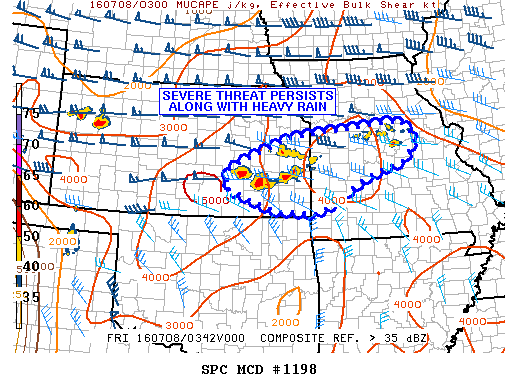
NOAA Storm Prediction Center Severe Thunderstorm Watch 353
WW 353 SEVERE TSTM KS MO 080120Z – 080700Z URGENT – IMMEDIATE BROADCAST REQUESTED SEVERE THUNDERSTORM WATCH NUMBER 353 NWS STORM PREDICTION CENTER NORMAN OK 820 PM CDT THU JUL 7 2016 THE NWS STORM PREDICTION CENTER HAS ISSUED A * SEVERE THUNDERSTORM WATCH FOR PORTIONS OF EASTERN KANSAS WESTERN AND CENTRAL MISSOURI * EFFECTIVE THIS THURSDAY NIGHT AND FRIDAY… Read more →