Primary Menu Search
  • About us
    • About us
    • How We Forecast
    • Archives
  • Our Services
    • Live Stream: Severe Weather Discussions
    • Go Storm Chasing
    • Pictures
  • Contact Us!
  • Jobs
  • Weather Safety
    • Weather Safety
    • Hurricane Preparedness Tips
    • Road Conditions
    • Current Conditions
    • South Mississippi river forecasts
    • Forecasting Presentation
  • Login

NickelBlock Forecasting

Funny name. Serious data.

Secondary Menu
  • Severe Weather Outlook
    • Severe Outlook through Day 8
    • Severe Outlook By State
    • Today’s Severe Weather Threat
    • Today’s Tornado Threat
    • Today’s Severe Wind Threat
    • Today’s Severe Hail Threat
    • Excessive Rainfall Forecasts
  • Short Term Forecast
    • Current Radar & Satellite
    • Detailed National Forecast Discussion
    • National Surface Maps
    • National Temperatures
    • National Precipitation Chances
    • National Precipitation Estimates
    • National Snowfall Estimates
    • National Ice Estimates
    • National Convective Outlook
    • Public RAPTOR Map
    • Model Data Viewer
  • Tropics
  • 10 Day Trend
  • Seasonal Discussion
You are here: Home ∼ Page 255

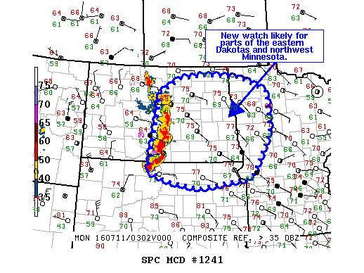
NOAA Storm Prediction Center Severe Thunderstorm Watch 370

Alomar Sharpe Sunday, July 10, 2016 // 10:40 pm

WW 370 SEVERE TSTM MN ND SD 110340Z – 110800Z URGENT – IMMEDIATE BROADCAST REQUESTED SEVERE THUNDERSTORM WATCH NUMBER 370 NWS STORM PREDICTION CENTER NORMAN OK 1040 PM CDT SUN JUL 10 2016 THE NWS STORM PREDICTION CENTER HAS ISSUED A * SEVERE THUNDERSTORM WATCH FOR PORTIONS OF NORTHWEST MINNESOTA EASTERN NORTH DAKOTA NORTHEAST SOUTH DAKOTA * EFFECTIVE THIS SUNDAY… Read more →

Posted in Archive, Severe Weather Discussions | Tagged Severe Weather, Watches and Warnings, weather
NOAA Storm Prediction Center Mesoscale Discussion 1241

NOAA Storm Prediction Center Mesoscale Discussion 1241

Alomar Sharpe Sunday, July 10, 2016 // 10:17 pm

MD 1241 CONCERNING SEVERE THUNDERSTORM WATCH 369… FOR CNTRL/ERN ND…N-CNTRL/NERN SD…NWRN MN MESOSCALE DISCUSSION 1241 NWS STORM PREDICTION CENTER NORMAN OK 1016 PM CDT SUN JUL 10 2016 AREAS AFFECTED…CNTRL/ERN ND…N-CNTRL/NERN SD…NWRN MN CONCERNING…SEVERE THUNDERSTORM WATCH 369… VALID 110316Z – 110445Z THE SEVERE WEATHER THREAT FOR SEVERE THUNDERSTORM WATCH 369 CONTINUES. SUMMARY…DMGG WINDS AND MARGINALLY SVR HAIL REMAIN POSSIBLE AS… Read more →

Posted in Archive, Severe Weather Discussions | Tagged Severe Weather, Watches and Warnings, weather

NOAA Storm Prediction Center – No Mesoscale Discussions are in effect as of Mon Jul 11 02:31:02 UTC 2016

Alomar Sharpe Sunday, July 10, 2016 // 9:30 pm

No Mesoscale Discussions are in effect as of Mon Jul 11 02:31:02 UTC 2016. Powered by WPeMatico

Posted in Archive, Severe Weather Discussions | Tagged Severe Weather, Watches and Warnings, weather
Storm Prediction Center Jul 11, 2016 UTC Evening Outlook

Storm Prediction Center Jul 11, 2016 UTC Evening Outlook

Alomar Sharpe Sunday, July 10, 2016 // 8:40 pm

SPC 0100Z Day 1 Outlook DAY 1 CONVECTIVE OUTLOOK NWS STORM PREDICTION CENTER NORMAN OK 0748 PM CDT SUN JUL 10 2016 VALID 110100Z – 111200Z …THERE IS AN ENH RISK OF SEVERE THUNDERSTORMS CENTERED OVER ND INTO NERN SD… …THERE IS A SLGT RISK OF SEVERE THUNDERSTORMS FROM ERN MT EWD INTO WRN MN… …THERE IS A MRGL RISK… Read more →

Posted in Archive, Severe Weather Discussions | Tagged Severe Weather, weather
NOAA Storm Prediction Center Mesoscale Discussion 1240

NOAA Storm Prediction Center Mesoscale Discussion 1240

Alomar Sharpe Sunday, July 10, 2016 // 7:55 pm

MD 1240 CONCERNING SEVERE POTENTIAL…WATCH POSSIBLE FOR WRN/CNTRL SD MESOSCALE DISCUSSION 1240 NWS STORM PREDICTION CENTER NORMAN OK 0754 PM CDT SUN JUL 10 2016 AREAS AFFECTED…WRN/CNTRL SD CONCERNING…SEVERE POTENTIAL…WATCH POSSIBLE VALID 110054Z – 110230Z PROBABILITY OF WATCH ISSUANCE…60 PERCENT SUMMARY…HIGH-BASED TSTMS HAVE DEVELOPED ACROSS THE NWRN NEB PANHANDLE…AND ARE MOVING NEWD INTO A GRADUALLY MORE MOIST/UNSTABLE AIR MASS ACROSS… Read more →

Posted in Archive, Severe Weather Discussions | Tagged Severe Weather, Watches and Warnings, weather
← Previous 1 … 254 255 256 … 2,028 Next →

Today’s Severe Weather Threat

SVR WX THREAT

Today’s Tornado Threat

SVR WX THREAT

Search The Site

Contributing Scientists

  • Alomar Sharpe
  • Amber Kulick
  • Branden Walker
  • Chris Vagasky
  • Colt Murray
  • Emily Riter
  • Kendall Junker
  • Matt Breland
  • Nick Lilja
  • NickelBlock Staff
  • Noah Gower

Wx Topics

2019 Atlantic Hurricane Season 2020 Atlantic hurricane Season Alabama Weather Amarillo weather Atlantic Hurricane Season Coronavirus COVID-19 COVID19 Earthquakes Flooding Geology Gulf Coast Weather hail hurricanes Louisiana Weather Mississippi Weather rain Severe Weather snow Texas Weather Thunderstorms Tornadoes Tropical Depressions Tropical Storms Tropical Weather tropics USGS Watches and Warnings weather Wind

What We Cover

  • Archive (10,136)
  • Climate (64)
  • Education (230)
  • Environment (8)
  • Forecasting (467)
  • Geology (210)
  • High Plains Weather (119)
  • Midwest Weather (35)
  • Northeast Weather (13)
  • Northwest Weather (5)
  • Not Weather (93)
  • Research (31)
  • River Flooding (23)
  • Severe Weather Discussions (8,640)
  • South Plains Weather (69)
  • Southeast Weather (312)
  • Space (19)
  • Storm Chasing (86)
  • Tropics (450)
  • Weather & Sports (4)
  • Weather & TV (37)
  • Weather History (8)
  • West Coast Weather (4)

Research

  • Conclusion: How multiple variables control TX/OK panhandle Spring severe weather
  • Findings: How multiple variables control TX/OK panhandle Spring severe weather
  • Methods: How multiple variables control TX/OK panhandle Spring severe weather
  • Introduction: How multiple variables control TX/OK panhandle Spring severe weather
  • Works Cited: How multiple variables control TX/OK panhandle Spring severe weather

Popular This Month

  • Remember that “Arctic Blast” people were posting about? Buckle up (6,957)
  • Another “Arctic Blast!” headed to the southeast says social media-rologists (2,420)
  • Arctic blast plunges Mississippi into ice age-like conditions colder than one of the moons of Jupiter (2,410)
  • More cold and snow has South Mississippi feeling like South Manitoba (1,888)
  • More wintry weather possible in South Mississippi next week (1,854)
  • Enough with the “Meteorologists get paid to be wrong” (1,617)
  • Afternoon Update: Snow possible for South Mississippi (960)
  • CIPS Analogs showing thunderstorms, possible severe weather, late next week for south Mississippi (949)
  • Freezing weather won’t kill all mosquitos (664)
  • Jan 16, south Mississippi morning snowfall update (541)
  • Instantly freeze water to make stalagmites (333)
  • Will it snow? A brief look at the steps to get it (318)

Primary Menu

  • About us
    • About us
    • How We Forecast
    • Archives
  • Our Services
    • Live Stream: Severe Weather Discussions
    • Go Storm Chasing
    • Pictures
  • Contact Us!
  • Jobs
  • Weather Safety
    • Weather Safety
    • Hurricane Preparedness Tips
    • Road Conditions
    • Current Conditions
    • South Mississippi river forecasts
    • Forecasting Presentation
  • Login

Secondary Menu

  • Severe Weather Outlook
    • Severe Outlook through Day 8
    • Severe Outlook By State
    • Today’s Severe Weather Threat
    • Today’s Tornado Threat
    • Today’s Severe Wind Threat
    • Today’s Severe Hail Threat
    • Excessive Rainfall Forecasts
  • Short Term Forecast
    • Current Radar & Satellite
    • Detailed National Forecast Discussion
    • National Surface Maps
    • National Temperatures
    • National Precipitation Chances
    • National Precipitation Estimates
    • National Snowfall Estimates
    • National Ice Estimates
    • National Convective Outlook
    • Public RAPTOR Map
    • Model Data Viewer
  • Tropics
  • 10 Day Trend
  • Seasonal Discussion

Copyright © 2026 NickelBlock Forecasting.

Powered by WordPress and Path. Back to Top

Google+
  • About us
  • Our Services
  • Contact Us!
  • Jobs
  • Weather Safety
  • Login