Primary Menu Search
  • About us
    • About us
    • How We Forecast
    • Archives
  • Our Services
    • Live Stream: Severe Weather Discussions
    • Go Storm Chasing
    • Pictures
  • Contact Us!
  • Jobs
  • Weather Safety
    • Weather Safety
    • Hurricane Preparedness Tips
    • Road Conditions
    • Current Conditions
    • South Mississippi river forecasts
    • Forecasting Presentation
  • Login

NickelBlock Forecasting

Funny name. Serious data.

Secondary Menu
  • Severe Weather Outlook
    • Severe Outlook through Day 8
    • Severe Outlook By State
    • Today’s Severe Weather Threat
    • Today’s Tornado Threat
    • Today’s Severe Wind Threat
    • Today’s Severe Hail Threat
    • Excessive Rainfall Forecasts
  • Short Term Forecast
    • Current Radar & Satellite
    • Detailed National Forecast Discussion
    • National Surface Maps
    • National Temperatures
    • National Precipitation Chances
    • National Precipitation Estimates
    • National Snowfall Estimates
    • National Ice Estimates
    • National Convective Outlook
    • Public RAPTOR Map
    • Model Data Viewer
  • Tropics
  • 10 Day Trend
  • Seasonal Discussion
You are here: Home ∼ Page 230

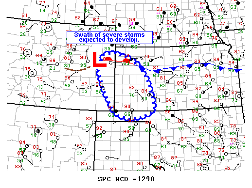
NOAA Storm Prediction Center Severe Thunderstorm Watch 388

Alomar Sharpe Friday, July 15, 2016 // 2:10 pm

WW 388 SEVERE TSTM CO KS NE 151910Z – 160200Z URGENT – IMMEDIATE BROADCAST REQUESTED SEVERE THUNDERSTORM WATCH NUMBER 388 NWS STORM PREDICTION CENTER NORMAN OK 210 PM CDT FRI JUL 15 2016 THE NWS STORM PREDICTION CENTER HAS ISSUED A * SEVERE THUNDERSTORM WATCH FOR PORTIONS OF SOUTHEAST COLORADO WESTERN KANSAS SOUTHWEST NEBRASKA * EFFECTIVE THIS FRIDAY AFTERNOON AND… Read more →

Posted in Archive, Severe Weather Discussions | Tagged Severe Weather, Watches and Warnings, weather
NOAA Storm Prediction Center Mesoscale Discussion 1290

NOAA Storm Prediction Center Mesoscale Discussion 1290

Alomar Sharpe Friday, July 15, 2016 // 1:45 pm

MD 1290 CONCERNING SEVERE POTENTIAL…SEVERE THUNDERSTORM WATCH LIKELY FOR WESTERN KS…FAR EASTERN CO…OK PANHANDLE MESOSCALE DISCUSSION 1290 NWS STORM PREDICTION CENTER NORMAN OK 0144 PM CDT FRI JUL 15 2016 AREAS AFFECTED…WESTERN KS…FAR EASTERN CO…OK PANHANDLE CONCERNING…SEVERE POTENTIAL…SEVERE THUNDERSTORM WATCH LIKELY VALID 151844Z – 152015Z PROBABILITY OF WATCH ISSUANCE…95 PERCENT SUMMARY…A CLUSTER OF SEVERE STORMS WILL FORM OVER EASTERN COLORADO… Read more →

Posted in Archive, Severe Weather Discussions | Tagged Severe Weather, Watches and Warnings, weather
NOAA Storm Prediction Center Mesoscale Discussion 1289

NOAA Storm Prediction Center Mesoscale Discussion 1289

Alomar Sharpe Friday, July 15, 2016 // 12:29 pm

MD 1289 CONCERNING SEVERE POTENTIAL…WATCH UNLIKELY FOR MUCH OF NORTH CAROLINA AND SOUTH CAROLINA MESOSCALE DISCUSSION 1289 NWS STORM PREDICTION CENTER NORMAN OK 1228 PM CDT FRI JUL 15 2016 AREAS AFFECTED…MUCH OF NORTH CAROLINA AND SOUTH CAROLINA CONCERNING…SEVERE POTENTIAL…WATCH UNLIKELY VALID 151728Z – 151930Z PROBABILITY OF WATCH ISSUANCE…20 PERCENT SUMMARY…ISOLATED/SPORADIC WIND DAMAGE POSSIBLE NEAR STRONGER THUNDERSTORMS THIS AFTERNOON. A… Read more →

Posted in Archive, Severe Weather Discussions | Tagged Severe Weather, Watches and Warnings, weather

NOAA Storm Prediction Center – No Mesoscale Discussions are in effect as of Fri Jul 15 14:46:01 UTC 2016

Alomar Sharpe Friday, July 15, 2016 // 9:45 am

No Mesoscale Discussions are in effect as of Fri Jul 15 14:46:01 UTC 2016. Powered by WPeMatico

Posted in Archive, Severe Weather Discussions | Tagged Severe Weather, Watches and Warnings, weather
Storm Prediction Center Jul 15, 2016 Morning Outlook

Storm Prediction Center Jul 15, 2016 Morning Outlook

Alomar Sharpe Friday, July 15, 2016 // 8:35 am

SPC 1300Z Day 1 Outlook DAY 1 CONVECTIVE OUTLOOK NWS STORM PREDICTION CENTER NORMAN OK 0756 AM CDT FRI JUL 15 2016 VALID 151300Z – 161200Z …THERE IS A SLGT RISK OF SEVERE THUNDERSTORMS ACROSS THE CENTRAL/SOUTHERN PLAINS… …THERE IS A MRGL RISK OF SEVERE THUNDERSTORMS FROM THE HIGH PLAINS TO THE OH VALLEY/SOUTHEAST STATES… …SUMMARY… SCATTERED SEVERE THUNDERSTORMS ARE… Read more →

Posted in Archive, Severe Weather Discussions | Tagged Severe Weather, weather
← Previous 1 … 229 230 231 … 2,028 Next →

Today’s Severe Weather Threat

SVR WX THREAT

Today’s Tornado Threat

SVR WX THREAT

Search The Site

Contributing Scientists

  • Alomar Sharpe
  • Amber Kulick
  • Branden Walker
  • Chris Vagasky
  • Colt Murray
  • Emily Riter
  • Kendall Junker
  • Matt Breland
  • Nick Lilja
  • NickelBlock Staff
  • Noah Gower

Wx Topics

2019 Atlantic Hurricane Season 2020 Atlantic hurricane Season Alabama Weather Amarillo weather Atlantic Hurricane Season Coronavirus COVID-19 COVID19 Earthquakes Flooding Geology Gulf Coast Weather hail hurricanes Louisiana Weather Mississippi Weather rain Severe Weather snow Texas Weather Thunderstorms Tornadoes Tropical Depressions Tropical Storms Tropical Weather tropics USGS Watches and Warnings weather Wind

What We Cover

  • Archive (10,136)
  • Climate (64)
  • Education (230)
  • Environment (8)
  • Forecasting (467)
  • Geology (210)
  • High Plains Weather (119)
  • Midwest Weather (35)
  • Northeast Weather (13)
  • Northwest Weather (5)
  • Not Weather (93)
  • Research (31)
  • River Flooding (23)
  • Severe Weather Discussions (8,640)
  • South Plains Weather (69)
  • Southeast Weather (312)
  • Space (19)
  • Storm Chasing (86)
  • Tropics (450)
  • Weather & Sports (4)
  • Weather & TV (37)
  • Weather History (8)
  • West Coast Weather (4)

Research

  • Conclusion: How multiple variables control TX/OK panhandle Spring severe weather
  • Findings: How multiple variables control TX/OK panhandle Spring severe weather
  • Methods: How multiple variables control TX/OK panhandle Spring severe weather
  • Introduction: How multiple variables control TX/OK panhandle Spring severe weather
  • Works Cited: How multiple variables control TX/OK panhandle Spring severe weather

Popular This Month

  • Remember that “Arctic Blast” people were posting about? Buckle up (6,957)
  • Another “Arctic Blast!” headed to the southeast says social media-rologists (2,420)
  • Arctic blast plunges Mississippi into ice age-like conditions colder than one of the moons of Jupiter (2,410)
  • More cold and snow has South Mississippi feeling like South Manitoba (1,888)
  • More wintry weather possible in South Mississippi next week (1,854)
  • Enough with the “Meteorologists get paid to be wrong” (1,617)
  • Afternoon Update: Snow possible for South Mississippi (960)
  • CIPS Analogs showing thunderstorms, possible severe weather, late next week for south Mississippi (949)
  • Freezing weather won’t kill all mosquitos (664)
  • Jan 16, south Mississippi morning snowfall update (541)
  • Instantly freeze water to make stalagmites (333)
  • Will it snow? A brief look at the steps to get it (318)

Primary Menu

  • About us
    • About us
    • How We Forecast
    • Archives
  • Our Services
    • Live Stream: Severe Weather Discussions
    • Go Storm Chasing
    • Pictures
  • Contact Us!
  • Jobs
  • Weather Safety
    • Weather Safety
    • Hurricane Preparedness Tips
    • Road Conditions
    • Current Conditions
    • South Mississippi river forecasts
    • Forecasting Presentation
  • Login

Secondary Menu

  • Severe Weather Outlook
    • Severe Outlook through Day 8
    • Severe Outlook By State
    • Today’s Severe Weather Threat
    • Today’s Tornado Threat
    • Today’s Severe Wind Threat
    • Today’s Severe Hail Threat
    • Excessive Rainfall Forecasts
  • Short Term Forecast
    • Current Radar & Satellite
    • Detailed National Forecast Discussion
    • National Surface Maps
    • National Temperatures
    • National Precipitation Chances
    • National Precipitation Estimates
    • National Snowfall Estimates
    • National Ice Estimates
    • National Convective Outlook
    • Public RAPTOR Map
    • Model Data Viewer
  • Tropics
  • 10 Day Trend
  • Seasonal Discussion

Copyright © 2026 NickelBlock Forecasting.

Powered by WordPress and Path. Back to Top

Google+
  • About us
  • Our Services
  • Contact Us!
  • Jobs
  • Weather Safety
  • Login