Primary Menu Search
  • About us
    • About us
    • How We Forecast
    • Archives
  • Our Services
    • Live Stream: Severe Weather Discussions
    • Go Storm Chasing
    • Pictures
  • Contact Us!
  • Jobs
  • Weather Safety
    • Weather Safety
    • Hurricane Preparedness Tips
    • Road Conditions
    • Current Conditions
    • South Mississippi river forecasts
    • Forecasting Presentation
  • Login

NickelBlock Forecasting

Funny name. Serious data.

Secondary Menu
  • Severe Weather Outlook
    • Severe Outlook through Day 8
    • Severe Outlook By State
    • Today’s Severe Weather Threat
    • Today’s Tornado Threat
    • Today’s Severe Wind Threat
    • Today’s Severe Hail Threat
    • Excessive Rainfall Forecasts
  • Short Term Forecast
    • Current Radar & Satellite
    • Detailed National Forecast Discussion
    • National Surface Maps
    • National Temperatures
    • National Precipitation Chances
    • National Precipitation Estimates
    • National Snowfall Estimates
    • National Ice Estimates
    • National Convective Outlook
    • Public RAPTOR Map
    • Model Data Viewer
  • Tropics
  • 10 Day Trend
  • Seasonal Discussion
You are here: Home ∼ Page 2011

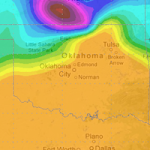
This afternoon is looking interesting, but not impressive, if you are a storm chaser. As an area of low pressure pushes into the four corners region it will help offer some lift our ahead of it. That means the chance for showers and storms in Texas, Oklahoma and Kansas.

The question will be how developed can these storms become. And how fast.

8z RAP Skew-T at 21z 5/8/13
8z RAP Skew-T for Amarillo (West of dry-line) at 21z 5/8/13

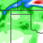
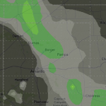
For places east of a line from Garden City, Kansas south to Turpin, Oklahoma and continuing to Paducah, Texas there is a chance for some afternoon showers and thunderstorms. Some of these storms could become severe.

The main threats for today are large hail and damaging winds. In fact hail stones in excess of two-inches (think egg-sized) could be seen across parts of western Oklahoma.

But that’s not all, we also have to worry about a tornado threat this afternoon. While the SPC has issued a 5-percent tornado risk, I feel like that might be edged back to just a 2-percent as we head toward the afternoon.

But even at 2-percent, I think a tornado will be seen somewhere today.

Status updated on Wednesday, May 8, 2013 // 3:50 am | Permalink

I’ll be out there… Who’s with me?

SPC Tornado Risk
Tornado Risk for May 8th, 2013 as of 4:00am
Image published on Wednesday, May 8, 2013 // 3:27 am | Permalink
High Plains rain chances... No, seriously!

High Plains rain chances… No, seriously!

Nick Lilja Monday, May 6, 2013 // 8:40 am

I know it feels like forever since the Texas and Oklahoma panhandles have received any rainfall. While it hasn’t been THAT long in the grand scheme of things it has been almost two full months since we received .10″ of rain or more. Seriously. Our last rainfall of .10″ or more was March, 8th. In fact, since the Blizzard of… Read more →

Posted in Archive, High Plains Weather | Tagged Amarillo weather, rain, Thunderstorms
High plains rain chances return

High plains rain chances return

Nick Lilja Thursday, April 25, 2013 // 3:04 am

Climatologically speaking late April means better chances for showers and storms across the high plains. So as a few disturbances move across the Texas panhandle, it’s important to keep an eye to the sky. Almost each of th next seven days shows the potential for a shower or storm. Quick Breakdown Today: Mostly cloudy conditions will prevail. Teh sun will… Read more →

Posted in Archive, High Plains Weather | Tagged Amarillo weather, rain, Storms
Severe weather anticipated across southern plains

Severe weather anticipated across southern plains

Nick Lilja Tuesday, April 16, 2013 // 10:56 am

Hail, high winds, tornadoes… And snow? The high plains, central plains and south plains are all bracing for another round of severe weather followed by another bout with Jack Frost. It’s like the uncle that won’t leave the Christmas party – winter is holding on, refusing to move. As an upper low pinwheels it’s way through the Great Basin and… Read more →

Posted in Archive, High Plains Weather, Midwest Weather, Storm Chasing | Tagged hail, Oklahoma Weather, Severe Thunderstorms, Tornadoes, Wind
← Previous 1 … 2,010 2,011 2,012 … 2,028 Next →

Today’s Severe Weather Threat

SVR WX THREAT

Today’s Tornado Threat

SVR WX THREAT

Search The Site

Contributing Scientists

  • Alomar Sharpe
  • Amber Kulick
  • Branden Walker
  • Chris Vagasky
  • Colt Murray
  • Emily Riter
  • Kendall Junker
  • Matt Breland
  • Nick Lilja
  • NickelBlock Staff
  • Noah Gower

Wx Topics

2019 Atlantic Hurricane Season 2020 Atlantic hurricane Season Alabama Weather Amarillo weather Atlantic Hurricane Season Coronavirus COVID-19 COVID19 Earthquakes Flooding Geology Gulf Coast Weather hail hurricanes Louisiana Weather Mississippi Weather rain Severe Weather snow Texas Weather Thunderstorms Tornadoes Tropical Depressions Tropical Storms Tropical Weather tropics USGS Watches and Warnings weather Wind

What We Cover

  • Archive (10,136)
  • Climate (64)
  • Education (230)
  • Environment (8)
  • Forecasting (467)
  • Geology (210)
  • High Plains Weather (119)
  • Midwest Weather (35)
  • Northeast Weather (13)
  • Northwest Weather (5)
  • Not Weather (93)
  • Research (31)
  • River Flooding (23)
  • Severe Weather Discussions (8,640)
  • South Plains Weather (69)
  • Southeast Weather (312)
  • Space (19)
  • Storm Chasing (86)
  • Tropics (450)
  • Weather & Sports (4)
  • Weather & TV (37)
  • Weather History (8)
  • West Coast Weather (4)

Research

  • Conclusion: How multiple variables control TX/OK panhandle Spring severe weather
  • Findings: How multiple variables control TX/OK panhandle Spring severe weather
  • Methods: How multiple variables control TX/OK panhandle Spring severe weather
  • Introduction: How multiple variables control TX/OK panhandle Spring severe weather
  • Works Cited: How multiple variables control TX/OK panhandle Spring severe weather

Popular This Month

  • Remember that “Arctic Blast” people were posting about? Buckle up (6,957)
  • Another “Arctic Blast!” headed to the southeast says social media-rologists (2,420)
  • Arctic blast plunges Mississippi into ice age-like conditions colder than one of the moons of Jupiter (2,410)
  • More cold and snow has South Mississippi feeling like South Manitoba (1,888)
  • More wintry weather possible in South Mississippi next week (1,854)
  • Enough with the “Meteorologists get paid to be wrong” (1,617)
  • Afternoon Update: Snow possible for South Mississippi (960)
  • CIPS Analogs showing thunderstorms, possible severe weather, late next week for south Mississippi (949)
  • Freezing weather won’t kill all mosquitos (664)
  • Jan 16, south Mississippi morning snowfall update (541)
  • Instantly freeze water to make stalagmites (333)
  • Will it snow? A brief look at the steps to get it (318)

Primary Menu

  • About us
    • About us
    • How We Forecast
    • Archives
  • Our Services
    • Live Stream: Severe Weather Discussions
    • Go Storm Chasing
    • Pictures
  • Contact Us!
  • Jobs
  • Weather Safety
    • Weather Safety
    • Hurricane Preparedness Tips
    • Road Conditions
    • Current Conditions
    • South Mississippi river forecasts
    • Forecasting Presentation
  • Login

Secondary Menu

  • Severe Weather Outlook
    • Severe Outlook through Day 8
    • Severe Outlook By State
    • Today’s Severe Weather Threat
    • Today’s Tornado Threat
    • Today’s Severe Wind Threat
    • Today’s Severe Hail Threat
    • Excessive Rainfall Forecasts
  • Short Term Forecast
    • Current Radar & Satellite
    • Detailed National Forecast Discussion
    • National Surface Maps
    • National Temperatures
    • National Precipitation Chances
    • National Precipitation Estimates
    • National Snowfall Estimates
    • National Ice Estimates
    • National Convective Outlook
    • Public RAPTOR Map
    • Model Data Viewer
  • Tropics
  • 10 Day Trend
  • Seasonal Discussion

Copyright © 2026 NickelBlock Forecasting.

Powered by WordPress and Path. Back to Top

Google+
  • About us
  • Our Services
  • Contact Us!
  • Jobs
  • Weather Safety
  • Login