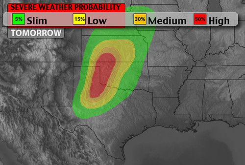
Here is a look at a severe weather discussion I posted to Facebook earlier…
Here is a look at a severe weather discussion I posted to Facebook earlier…
Here is a look at the severe weather threat for Monday. Give it a few seconds to load, it is pulled from Facebook…
Props to the Capital Weather Gang for this…
Busted! Cristobal's hurricane-hyped, 2,500 mile track error: http://t.co/cuxGjdU0Sf (ht @islivingston) pic.twitter.com/rE2uFaHrAf
— Capital Weather Gang (@capitalweather) August 29, 2014
(UPDATE 12:00 PM)
If you are here checking on today’s severe weather potential, please see our latest thoughts on today’s event here
(ORIGINAL ARTICLE: 5:00 PM)
It’s not often that the closer you get to a severe weather event the more difficult it becomes to forecast.
But, that is why weather is so fascinating.
As you start your morning in places like Amarillo, Wichita, Oklahoma city, Dallas and Lubbock – it appears right now that you won’t ahve to worry about severe weather. Well, maybe in Wichita. Mainly, though, it is between all of those cities that severe weather is a possibility. And, in all honesty, a likelihood.
But it isn’t as simple as that.
Right now, the models are having a difficult time accurately working through the data this afternoon because most of the computers are over-estimating the amount of available moisture and under-estimating the morning clouds and some light rain.
Both would throw a serious wrench in Mother Nature’s plans for severe weather.
The forecast will be monitored closely, but know if you live in places like Liberal, KS, Enid, OK, Clinton, OK, Shamrock, TX, Childress, TX or Lawton, OK your weather today is about as “wait and see” as it comes. The next few hours will tell us a lot about what to expect this afternoon.
For now, be prepared for severe weather, but also keep inmind, you might dodge a bullet this afternoon.
For a complete breakdown on today’s severe weather threat click here
The Storm Prediction Center in Norman, Oklahoma is watching parts of the Southern Plains and Great Plains for severe weather on Wednesday.

Right now, most computer weather models show modest instability, a weak cap, and adequate shear to support severe storms.
Here is a look at a breakdown of what the 12z NAM is showing for tomorrow. And a special thanks to TwisterData.com for the use of their maps.