Primary Menu Search
  • About us
    • About us
    • How We Forecast
    • Archives
  • Our Services
    • Live Stream: Severe Weather Discussions
    • Go Storm Chasing
    • Pictures
  • Contact Us!
  • Jobs
  • Weather Safety
    • Weather Safety
    • Hurricane Preparedness Tips
    • Road Conditions
    • Current Conditions
    • South Mississippi river forecasts
    • Forecasting Presentation
  • Login

NickelBlock Forecasting

Funny name. Serious data.

Secondary Menu
  • Severe Weather Outlook
    • Severe Outlook through Day 8
    • Severe Outlook By State
    • Today’s Severe Weather Threat
    • Today’s Tornado Threat
    • Today’s Severe Wind Threat
    • Today’s Severe Hail Threat
    • Excessive Rainfall Forecasts
  • Short Term Forecast
    • Current Radar & Satellite
    • Detailed National Forecast Discussion
    • National Surface Maps
    • National Temperatures
    • National Precipitation Chances
    • National Precipitation Estimates
    • National Snowfall Estimates
    • National Ice Estimates
    • National Convective Outlook
    • Public RAPTOR Map
    • Model Data Viewer
  • Tropics
  • 10 Day Trend
  • Seasonal Discussion
You are here: Home ∼ Page 1978
Latest Tornado Watch issued

Latest Tornado Watch issued

Nick Lilja Thursday, March 27, 2014 // 5:06 pm

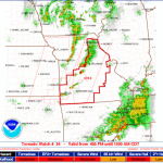
Here is the latest watch boxe from the Storm Prediction Center: “Moderate” threat for EF-2 or greater tornadoes. Be alert and weather aware.

Posted in Archive, South Plains Weather | Tagged hail, Severe Weather, Thunderstorms, Tornadoes, Wind

SPC Watch 0034 Initial Counties (WOU) Quick View

Alomar Sharpe Thursday, March 27, 2014 // 4:53 pm

WW 34 TORNADO MO 272155Z – 280500Z TORNADO WATCH OUTLINE UPDATE FOR WT 34 NWS STORM PREDICTION CENTER NORMAN OK 455 PM CDT THU MAR 27 2014 TORNADO WATCH 34 IS IN EFFECT UNTIL 1200 AM CDT FOR THE FOLLOWING LOCATIONS MOC007-009-011-015-019-027-029-039-043-051-055-057-059-065-067- 071-073-077-085-097-103-105-109-111-113-119-125-127-131-135-137- 139-141-145-151-153-161-163-167-169-173-185-205-209-213-215-219- 225-229-280500- /O.NEW.KWNS.TO.A.0034.140327T2155Z-140328T0500Z/ MO . MISSOURI COUNTIES INCLUDED ARE AUDRAIN BARRY BARTON BENTON BOONE CALLAWAY CAMDEN CEDAR… Read more →

Posted in Archive, Severe Weather Discussions | Tagged Severe Weather, Watches and Warnings, weather

SPC MD 212

Alomar Sharpe Thursday, March 27, 2014 // 3:51 pm

MD 0212 CONCERNING SEVERE POTENTIAL…WATCH LIKELY FOR ERN/S-CNTRL MO…FAR W-CNTRL IL MESOSCALE DISCUSSION 0212 NWS STORM PREDICTION CENTER NORMAN OK 0350 PM CDT THU MAR 27 2014 AREAS AFFECTED…ERN/S-CNTRL MO…FAR W-CNTRL IL CONCERNING…SEVERE POTENTIAL…WATCH LIKELY VALID 272050Z – 272145Z PROBABILITY OF WATCH ISSUANCE…80 PERCENT SUMMARY…ONGOING TSTM ACTIVITY ACROSS WRN MO /IN TORNADO WATCH 33/ IS EXPECTED TO PERSIST WITH UPSCALE… Read more →

Posted in Archive, Severe Weather Discussions | Tagged Severe Weather, Watches and Warnings, weather

SPC MD 211

Alomar Sharpe Thursday, March 27, 2014 // 2:51 pm

MD 0211 CONCERNING TORNADO WATCH 33… FOR WRN MO…FAR SERN KS…ERN OK MESOSCALE DISCUSSION 0211 NWS STORM PREDICTION CENTER NORMAN OK 0250 PM CDT THU MAR 27 2014 AREAS AFFECTED…WRN MO…FAR SERN KS…ERN OK CONCERNING…TORNADO WATCH 33… VALID 271950Z – 272115Z THE SEVERE WEATHER THREAT FOR TORNADO WATCH 33 CONTINUES. SUMMARY…ISOLATED SEVERE HAIL AND A FEW TORNADOES SHOULD REMAIN THE… Read more →

Posted in Archive, Severe Weather Discussions | Tagged Severe Weather, Watches and Warnings, weather

SPC MD 210

Alomar Sharpe Thursday, March 27, 2014 // 2:02 pm

MD 0210 CONCERNING SEVERE POTENTIAL…WATCH POSSIBLE FOR ERN TX…WRN LA MESOSCALE DISCUSSION 0210 NWS STORM PREDICTION CENTER NORMAN OK 0201 PM CDT THU MAR 27 2014 AREAS AFFECTED…ERN TX…WRN LA CONCERNING…SEVERE POTENTIAL…WATCH POSSIBLE VALID 271901Z – 272100Z PROBABILITY OF WATCH ISSUANCE…40 PERCENT SUMMARY…A CLUSTER OF STORMS ROOTED JUST ABOVE THE SURFACE SHOULD FORM BY LATE AFTERNOON WITHIN A PERSISTENT LOW-LEVEL… Read more →

Posted in Archive, Severe Weather Discussions | Tagged Severe Weather, Watches and Warnings, weather
← Previous 1 … 1,977 1,978 1,979 … 2,028 Next →

Today’s Severe Weather Threat

SVR WX THREAT

Today’s Tornado Threat

SVR WX THREAT

Search The Site

Contributing Scientists

  • Alomar Sharpe
  • Amber Kulick
  • Branden Walker
  • Chris Vagasky
  • Colt Murray
  • Emily Riter
  • Kendall Junker
  • Matt Breland
  • Nick Lilja
  • NickelBlock Staff
  • Noah Gower

Wx Topics

2019 Atlantic Hurricane Season 2020 Atlantic hurricane Season Alabama Weather Amarillo weather Atlantic Hurricane Season Coronavirus COVID-19 COVID19 Earthquakes Flooding Geology Gulf Coast Weather hail hurricanes Louisiana Weather Mississippi Weather rain Severe Weather snow Texas Weather Thunderstorms Tornadoes Tropical Depressions Tropical Storms Tropical Weather tropics USGS Watches and Warnings weather Wind

What We Cover

  • Archive (10,136)
  • Climate (64)
  • Education (230)
  • Environment (8)
  • Forecasting (467)
  • Geology (210)
  • High Plains Weather (119)
  • Midwest Weather (35)
  • Northeast Weather (13)
  • Northwest Weather (5)
  • Not Weather (93)
  • Research (31)
  • River Flooding (23)
  • Severe Weather Discussions (8,640)
  • South Plains Weather (69)
  • Southeast Weather (312)
  • Space (19)
  • Storm Chasing (86)
  • Tropics (450)
  • Weather & Sports (4)
  • Weather & TV (37)
  • Weather History (8)
  • West Coast Weather (4)

Research

  • Conclusion: How multiple variables control TX/OK panhandle Spring severe weather
  • Findings: How multiple variables control TX/OK panhandle Spring severe weather
  • Methods: How multiple variables control TX/OK panhandle Spring severe weather
  • Introduction: How multiple variables control TX/OK panhandle Spring severe weather
  • Works Cited: How multiple variables control TX/OK panhandle Spring severe weather

Popular This Month

  • Remember that “Arctic Blast” people were posting about? Buckle up (6,957)
  • Another “Arctic Blast!” headed to the southeast says social media-rologists (2,420)
  • Arctic blast plunges Mississippi into ice age-like conditions colder than one of the moons of Jupiter (2,410)
  • More cold and snow has South Mississippi feeling like South Manitoba (1,888)
  • More wintry weather possible in South Mississippi next week (1,854)
  • Enough with the “Meteorologists get paid to be wrong” (1,617)
  • Afternoon Update: Snow possible for South Mississippi (960)
  • CIPS Analogs showing thunderstorms, possible severe weather, late next week for south Mississippi (949)
  • Freezing weather won’t kill all mosquitos (664)
  • Jan 16, south Mississippi morning snowfall update (541)
  • Instantly freeze water to make stalagmites (333)
  • Will it snow? A brief look at the steps to get it (318)

Primary Menu

  • About us
    • About us
    • How We Forecast
    • Archives
  • Our Services
    • Live Stream: Severe Weather Discussions
    • Go Storm Chasing
    • Pictures
  • Contact Us!
  • Jobs
  • Weather Safety
    • Weather Safety
    • Hurricane Preparedness Tips
    • Road Conditions
    • Current Conditions
    • South Mississippi river forecasts
    • Forecasting Presentation
  • Login

Secondary Menu

  • Severe Weather Outlook
    • Severe Outlook through Day 8
    • Severe Outlook By State
    • Today’s Severe Weather Threat
    • Today’s Tornado Threat
    • Today’s Severe Wind Threat
    • Today’s Severe Hail Threat
    • Excessive Rainfall Forecasts
  • Short Term Forecast
    • Current Radar & Satellite
    • Detailed National Forecast Discussion
    • National Surface Maps
    • National Temperatures
    • National Precipitation Chances
    • National Precipitation Estimates
    • National Snowfall Estimates
    • National Ice Estimates
    • National Convective Outlook
    • Public RAPTOR Map
    • Model Data Viewer
  • Tropics
  • 10 Day Trend
  • Seasonal Discussion

Copyright © 2026 NickelBlock Forecasting.

Powered by WordPress and Path. Back to Top

Google+
  • About us
  • Our Services
  • Contact Us!
  • Jobs
  • Weather Safety
  • Login