Primary Menu Search
  • About us
    • About us
    • How We Forecast
    • Archives
  • Our Services
    • Live Stream: Severe Weather Discussions
    • Go Storm Chasing
    • Pictures
  • Contact Us!
  • Jobs
  • Weather Safety
    • Weather Safety
    • Hurricane Preparedness Tips
    • Road Conditions
    • Current Conditions
    • South Mississippi river forecasts
    • Forecasting Presentation
  • Login

NickelBlock Forecasting

Funny name. Serious data.

Secondary Menu
  • Severe Weather Outlook
    • Severe Outlook through Day 8
    • Severe Outlook By State
    • Today’s Severe Weather Threat
    • Today’s Tornado Threat
    • Today’s Severe Wind Threat
    • Today’s Severe Hail Threat
    • Excessive Rainfall Forecasts
  • Short Term Forecast
    • Current Radar & Satellite
    • Detailed National Forecast Discussion
    • National Surface Maps
    • National Temperatures
    • National Precipitation Chances
    • National Precipitation Estimates
    • National Snowfall Estimates
    • National Ice Estimates
    • National Convective Outlook
    • Public RAPTOR Map
    • Model Data Viewer
  • Tropics
  • 10 Day Trend
  • Seasonal Discussion
You are here: Home ∼ Page 1897

Pictures: Severe weather rolls through south

Colt Murray Monday, April 28, 2014 // 7:22 am

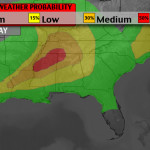
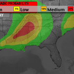
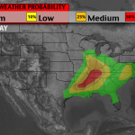
This morning, social media is inundated with pictures from the destruction caused by yesterday’s severe weather.

Campers and RVs that were for sale scattered on both sides of I-40 near Mayflower exit. #artornado #arwx pic.twitter.com/EqnhspCzKF

— Alyssa Raymond (@AlyssaRaymond) April 28, 2014

Picture: RT @mikeseidel: Three big RVs wrapped around a twisted I-40 billboard in Mayflower, #AR. pic.twitter.com/8g7yHg6Ftr #tornado

— Johnny Kelly (@stormchaser4850) April 28, 2014

RT @TWCMattSampson #Tornado damage in #Quapaw, OK visible now at first light. #OKwx #severe @weatherchannel pic.twitter.com/kMFQAnxKM8

— Jennifer Wojcicki (@yourmetjenny) April 28, 2014

A couple of RV campers balled into one here in Mayflower. #arwx #KATV pic.twitter.com/JbQm5j5MJT

— Justin Lewis (@JustinLewisLR) April 28, 2014

Jordan Hamilton and Tyler Costantini roll up on devastation in Mayflower, AR right after a tornado. http://t.co/P6DZ5jNwzR

— SevereStudios (@severestudios) April 28, 2014

Shattered lives & piles of debris in #Mayflower after a deadly #Arkansas #tornado – the latest ahead on @TodayShow pic.twitter.com/xIEMs4vW4Q

— Janet Shamlian (@JanetShamlian) April 28, 2014

∞

Aside published on Monday, April 28, 2014 // 7:22 am | Permalink

SPC MD 449

Alomar Sharpe Monday, April 28, 2014 // 7:17 am

MD 0449 CONCERNING TORNADO WATCH 107… FOR PARTS OF CNTRL AND NE LA…INTO CNTRL MS MESOSCALE DISCUSSION 0449 NWS STORM PREDICTION CENTER NORMAN OK 0716 AM CDT MON APR 28 2014 AREAS AFFECTED…PARTS OF CNTRL AND NE LA…INTO CNTRL MS CONCERNING…TORNADO WATCH 107… VALID 281216Z – 281345Z THE SEVERE WEATHER THREAT FOR TORNADO WATCH 107 CONTINUES. SUMMARY…SEVERE POTENTIAL…MAINLY WIND AND… Read more →

Posted in Archive, Severe Weather Discussions | Tagged Severe Weather, Watches and Warnings, weather

SPC MD 448

Alomar Sharpe Monday, April 28, 2014 // 6:58 am

MD 0448 CONCERNING TORNADO WATCH 106… FOR NRN MS…WRN AND MIDDLE TENNESSEE MESOSCALE DISCUSSION 0448 NWS STORM PREDICTION CENTER NORMAN OK 0657 AM CDT MON APR 28 2014 AREAS AFFECTED…NRN MS…WRN AND MIDDLE TENNESSEE CONCERNING…TORNADO WATCH 106… VALID 281157Z – 281400Z THE SEVERE WEATHER THREAT FOR TORNADO WATCH 106 CONTINUES. SUMMARY…SEVERE THREAT BEYOND WW 106…WHICH HAS BEEN EXPANDED TO INCLUDE… Read more →

Posted in Archive, Severe Weather Discussions | Tagged Severe Weather, Watches and Warnings, weather

Today’s Severe Weather Potential – 4/28/14

Issued: 4:30am
issued: 4:30am
Issued: 4:30am

Apologies for the late start everyone. We are currently working to track all of the severe weather watches and warnings tonight / this morning. Nick Lilja will have a complete severe weather breakdown and timetable posted later this morning.

Gallery published on Monday, April 28, 2014 // 4:47 am | Permalink

SPC Tornado Watch 107

Alomar Sharpe Monday, April 28, 2014 // 4:41 am

WW 107 TORNADO AR LA MS TX 280940Z – 281700Z URGENT – IMMEDIATE BROADCAST REQUESTED TORNADO WATCH NUMBER 107 NWS STORM PREDICTION CENTER NORMAN OK 440 AM CDT MON APR 28 2014 THE NWS STORM PREDICTION CENTER HAS ISSUED A * TORNADO WATCH FOR PORTIONS OF FAR SOUTHEAST ARKANSAS NORTHERN AND CENTRAL LOUISIANA WESTERN MISSISSIPPI SOUTHEAST TEXAS * EFFECTIVE THIS… Read more →

Posted in Archive, Severe Weather Discussions | Tagged Severe Weather, Watches and Warnings, weather
← Previous 1 … 1,896 1,897 1,898 … 2,028 Next →

Today’s Severe Weather Threat

SVR WX THREAT

Today’s Tornado Threat

SVR WX THREAT

Search The Site

Contributing Scientists

  • Alomar Sharpe
  • Amber Kulick
  • Branden Walker
  • Chris Vagasky
  • Colt Murray
  • Emily Riter
  • Kendall Junker
  • Matt Breland
  • Nick Lilja
  • NickelBlock Staff
  • Noah Gower

Wx Topics

2019 Atlantic Hurricane Season 2020 Atlantic hurricane Season Alabama Weather Amarillo weather Atlantic Hurricane Season Coronavirus COVID-19 COVID19 Earthquakes Flooding Geology Gulf Coast Weather hail hurricanes Louisiana Weather Mississippi Weather rain Severe Weather snow Texas Weather Thunderstorms Tornadoes Tropical Depressions Tropical Storms Tropical Weather tropics USGS Watches and Warnings weather Wind

What We Cover

  • Archive (10,136)
  • Climate (64)
  • Education (230)
  • Environment (8)
  • Forecasting (467)
  • Geology (210)
  • High Plains Weather (119)
  • Midwest Weather (35)
  • Northeast Weather (13)
  • Northwest Weather (5)
  • Not Weather (93)
  • Research (31)
  • River Flooding (23)
  • Severe Weather Discussions (8,640)
  • South Plains Weather (69)
  • Southeast Weather (312)
  • Space (19)
  • Storm Chasing (86)
  • Tropics (450)
  • Weather & Sports (4)
  • Weather & TV (37)
  • Weather History (8)
  • West Coast Weather (4)

Research

  • Conclusion: How multiple variables control TX/OK panhandle Spring severe weather
  • Findings: How multiple variables control TX/OK panhandle Spring severe weather
  • Methods: How multiple variables control TX/OK panhandle Spring severe weather
  • Introduction: How multiple variables control TX/OK panhandle Spring severe weather
  • Works Cited: How multiple variables control TX/OK panhandle Spring severe weather

Popular This Month

  • Remember that “Arctic Blast” people were posting about? Buckle up (6,957)
  • Another “Arctic Blast!” headed to the southeast says social media-rologists (2,420)
  • Arctic blast plunges Mississippi into ice age-like conditions colder than one of the moons of Jupiter (2,410)
  • More cold and snow has South Mississippi feeling like South Manitoba (1,888)
  • More wintry weather possible in South Mississippi next week (1,854)
  • Enough with the “Meteorologists get paid to be wrong” (1,617)
  • Afternoon Update: Snow possible for South Mississippi (960)
  • CIPS Analogs showing thunderstorms, possible severe weather, late next week for south Mississippi (949)
  • Freezing weather won’t kill all mosquitos (664)
  • Jan 16, south Mississippi morning snowfall update (541)
  • Instantly freeze water to make stalagmites (333)
  • Will it snow? A brief look at the steps to get it (318)

Primary Menu

  • About us
    • About us
    • How We Forecast
    • Archives
  • Our Services
    • Live Stream: Severe Weather Discussions
    • Go Storm Chasing
    • Pictures
  • Contact Us!
  • Jobs
  • Weather Safety
    • Weather Safety
    • Hurricane Preparedness Tips
    • Road Conditions
    • Current Conditions
    • South Mississippi river forecasts
    • Forecasting Presentation
  • Login

Secondary Menu

  • Severe Weather Outlook
    • Severe Outlook through Day 8
    • Severe Outlook By State
    • Today’s Severe Weather Threat
    • Today’s Tornado Threat
    • Today’s Severe Wind Threat
    • Today’s Severe Hail Threat
    • Excessive Rainfall Forecasts
  • Short Term Forecast
    • Current Radar & Satellite
    • Detailed National Forecast Discussion
    • National Surface Maps
    • National Temperatures
    • National Precipitation Chances
    • National Precipitation Estimates
    • National Snowfall Estimates
    • National Ice Estimates
    • National Convective Outlook
    • Public RAPTOR Map
    • Model Data Viewer
  • Tropics
  • 10 Day Trend
  • Seasonal Discussion

Copyright © 2026 NickelBlock Forecasting.

Powered by WordPress and Path. Back to Top

Google+
  • About us
  • Our Services
  • Contact Us!
  • Jobs
  • Weather Safety
  • Login