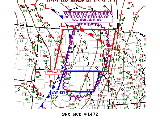
NOAA Storm Prediction Center Mesoscale Discussion 1472
MD 1472 CONCERNING TORNADO WATCH 430… FOR MOST OF ND…N-CNTRL SD…FAR NWRN MN MESOSCALE DISCUSSION 1472 NWS STORM PREDICTION CENTER NORMAN OK 0629 PM CDT WED AUG 03 2016 AREAS AFFECTED…MOST OF ND…N-CNTRL SD…FAR NWRN MN CONCERNING…TORNADO WATCH 430… VALID 032329Z – 040100Z THE SEVERE WEATHER THREAT FOR TORNADO WATCH 430 CONTINUES. SUMMARY…SUPERCELL ACROSS TOWNER COUNTY ND WILL CONTINUE TO… Read more →